Published September 20, 2013 05:56AM
Death Valley National Park: Ibex Dunes
Trek along the remote Ibex Dunes and wind through rugged washes on this 28-mile overnight near Death Valley National Park's southern border.
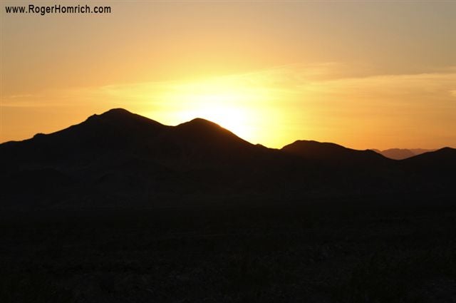
The seldom-traveled southern tip of Death Valley National Park offers an intimate desert experience amongst sand dunes, jagged hills, a 19th century talc mine, and a palm tree oasis.
Beginning at Harry Wade Road, this route rounds the base of Saddle Peak Hill and then climbs north through a narrow, secluded valley. (Views of the dunes appear as you round the hill.) As hikers near Ibex Dunes, the sand becomes softer and post-holing becomes the norm. Skirt the western perimeter of the dunes and walk through a narrow cut in the Saddle Peak Hills. The terrain gets increasingly more hard-packed as the route climbs gradually and slices between rolling ridges to the east and hills to the west.
After 5 miles, reach a real-life oasis. Ibex Spring is a tiny pocket of palm trees situated on the eastern slope of a rocky hillside. From here, follow an old mining road through a narrow gap in the hills. A broad wash sits between Black and Ibex Hills. Continue along the rutted wash toward the abandoned mine, using the hill’s white talc stains as a directional guide. No designated campsites or potable water are available. Choose an elevated site to avoid flash floods. Retrace steps back to Harry Wade Road in the morning.
-Mapped by Roger Homrich, the first person to thru-hike Death Valley Traverse.

Trail Facts
- Distance: 22.5
Waypoints
WPT001
ADVERTISEMENT
Location: 40.074348, -79.356098
Trailhead for the Indian Creek Trail. It is made of crushed limestone, and begins in the middle of a small field, which also serves as the parking area. The trailhead is between 2 creeks that are very close together. If you cross both creeks you’ve went to far. From the trailhead you can see that the trail follows Roaring Run Creek (about 20 feet wide). The trail is also straight for at least 1/4 mile.
WPT002
Location: 40.074137, -79.355787
Trail continues straight and into a wooded area canopied by trees.
WPT003
Location: 40.07331, -79.3559
Intersection with a stone road going diagonally left and back off the trail onto private property. Beyond this point is an old wood fence that zigzags between pines.
WPT004
Location: 40.071522, -79.356331
Parkbench on the left of the trail.
WPT005
Location: 40.068127, -79.356827
ADVERTISEMENT
Sandstone outcrop to the left of the trail about 5 or 6 feet above the ground with trees growing out of the rocks. About 100 feet ahead the trail makes a slight right turn
WPT006
Location: 40.065304, -79.357841
Trail is following a larger creek to the right; houses on the other side. There is also a fence to the right of the trail. To the left of the trail the land slopes up into the woods. Maple trees continue to canopy over the trail. Along the creek and in the woods are lots of rhododendron bushes.
WPT007
Location: 40.062553, -79.359856
Trail intersects with a path heading down steps to the right that leads to a bridge and a “No Trespassing” sign. There is also a lower trail running parallel to the main trail beyond the “No Trespassing” sign. Stay on the high trail. The trail makes a slight right turn.
WPT008
Location: 40.061806, -79.361114
One mile sign on the left of the trail.
WPT009
Location: 40.059505, -79.364677
ADVERTISEMENT
Road Crossing. The road runs down a hill from left to right. To the right the road crosses a small bridge. Just across the road is a faded sign that says “No Horses No Motor Vehicles Allowed” and a “1CV Trail” sign on a wooden post.
WPT010
Location: 40.057446, -79.367439
Trail hits a red fence open only large enough for pedestrians or bikes to get through. There is a faded white sign with red letters that says, “No Motor Vehicles or Horses”. To the right is a Scotty’s port-o-john. There is a small trail running just to the left and a dirt road running to the right. There are a lot of houses with wood piles along the right side of the trail and a few houses on the left. Trail remains canopied with trees on both sides. Watch for squirrels and chipmunks. The trail is not following the river at this point.
WPT011
Location: 40.055119, -79.371712
The first clearing on the trail is here where telephone wires cross the trail. Just beyond this waypoint the trail resumes following the creek to the right.
WPT012
Location: 40.053181, -79.376785
ADVERTISEMENT
There is a parkbench to the right and a blue trash can.
WPT013
Location: 40.052517, -79.378922
Trail comes to a partial clearing on the left. There is a long detention pond on the left. There are many Tulip and Willow trees to the right, which is a swampy area. On the other side of the detention pond are very large pine trees.
WPT014
Location: 40.051723, -79.382034
Trail crosses a road again, which begins as a private driveway to the left, and turns into a one lane road to the right with a bridge. Pass out of and back into a fenced area when crossing the road. There are many “Posted No Tresspassing Signs” just to the left of the trail. One can hear a lot of traffic at this point.
WPT015
Location: 40.048824, -79.39122
ADVERTISEMENT
Trail crosses the Indian Creek Valley Malcroft Trail Tressle. There is a historical rock marker to the right. Beyond is a wood fenced pedestrian bridge that leads to a road. Trail continues straight, do not cross tressle.
WPT016
Location: 40.04723, -79.394592
Trail has a sign to the left that says, “3 miles”.
WPT017
Location: 40.046711, -79.39534
To the right is a black arcuate hill that is made of either black shale or slag. The ground is covered with leaves where it is not black, and there are trees growing along the crest of the hill. There are also woods to the left and trees continue to canopy the trail.
WPT018
Location: 40.045708, -79.398987
Parkbench to the right
WPT019
Location: 40.04224, -79.401787
There is a stone wall about 20 feet off the left side of the trail. To the right of the trail is a hill dropping down 20-30′ into a flat forested area.
WPT020
Location: 40.037598, -79.399071
ADVERTISEMENT
There is a 4-mile sign to the left. There is a park bench just to the right and the trail turns slightly. Trail is still canopied by Oak, Maple and Poplar trees.
WPT021
Location: 40.034985, -79.399506
Trail appears to enter a very small town. Watch for domesticated rabbits and other farm animals on the loose. There are chickens and dogs under old trucks. There are lots of old buildings and junked and rusted vehicles (even an old school bus) all around the edge of the trail. The area is mostly a clearing with a few trees scattered around.
WPT022
Location: 40.033127, -79.39817
There is a port-o-potty to the right in a clearing. To the left is a line of trees. The trail has a 2 track appearence going off into the distance, and is still crushed limestone coated.
WPT023
Location: 40.032181, -79.396912
Cows in the woods to the left, and a sign to the right that says, “Max B. Nobel mine drainage remediation and interpretive wetlands area -Sagarmore Mountain Watershed Association”. There is a detention pond to the right.
WPT024
ADVERTISEMENT
Location: 40.030861, -79.395126
There is a sign that reads, “Mountain Watershed Association entrance point”, and it mentions that there is contaminated mine drainages entering a treatment pond.
WPT025
Location: 40.029377, -79.39399
There is a catch basin to the left. To the right is a long pond or part of a stream across which are houses. Trees line the right side of the trail/ left side of stream.
WPT026
Location: 40.02668, -79.39389
Cross two bridges within 100 feet of each other. There is also a fence just in front. To the right there is a park with lots of park tables, a pavillion, a gazebo and monkey bars.
WPT027
Location: 40.025791, -79.394615
Mile 5- To continue trail next 1 mile head down road turn right at light and across from the Indian Head bar the trail resumes
WPT028
Location: 40.024635, -79.396477
ADVERTISEMENT
Trail continues to the left of the Indian Head Bar. Head into a slightly wooded area.
WPT029
Location: 40.023125, -79.39682
Fence leading to trail. To the left is a windy road leading up a hill.
WPT030
Location: 40.023125, -79.39682
The PA state tree (Hemlock) appears to the right. The trail follows a fence beyond which is the creek. The ground cover is still crushed limestone. A large outcrop 10′- 15′ above the ground is thinnly layered shale. About 5′ above the ground is a coal seam about 1′ thick.
WPT031
Location: 40.02002, -79.403557
Telephone poles intersect the trail at a diagonal angle.
WPT032
Location: 40.019157, -79.405029
A picnic table and trash can is to the left. Just ahead is a fenced area before the trail turns gently to the left. Trail is canopied by trees and still running parallel to the stream.
WPT033
Location: 40.016472, -79.408882
ADVERTISEMENT
Pass through another fence. To the left are Ed Nicholson Lumber Company signs on the trees. There is another park bench. After passing the fence the trail is just dirt and no longer crushed limestone, and becomes much closer to the creek. The trail may end here, but I mapped it further. There is also massive crossbedded sandstone exposed to the right. Abundant ferns.
WPT034
Location: 40.016457, -79.408936
The trail crosses under 2 fallen trees.
WPT035
Location: 40.014977, -79.415487
The trail is heading away from the creek and into a thinly forested poplar and tulip tree area. A quarter to a half mile beyond this point the trail merges into a large open area that looks like it has been forested (trees cut down). There are some wood piles and signs everywhere that say no tresspassing. The trail becomes two thin tracks of dirt before this point