Published September 21, 2009 05:51PM
Plot an Off-Trail Route
Try these 10 tips for cross-country travel.
'october 09 offroad trail 200x170'
Looking to escape the crowds, scramble a trailless peak, or camp next to a secret, unnamed lake? Cross-country exploration is the ticket to all three. But cruising from trailhead to destination in a straight line is rarely the smartest option. Here’s how to use the newest tools to plot the best and safest route to your goal.
Choose a Map
For tricky off-trail navigation, you’ll want a paper 7.5-minute USGS quad for backup in the field. But digital maps are better for planning and storing route information. Mapping programs–many of them web-based and free–let you draw and save tracks, mark key points, calculate trip stats, and more. We humbly suggest Backpacker’s free Map Editor program (at backpacker.com/postatrip).
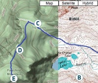
Scout the Terrain
Sketch your route with the software’s pencil tool. Use the terrain view (above, left) for big-picture scouting and the topo view (above, right) for more detailed planning. Below treeline, plan to hike on ridges, in wide valleys (A), and on slopes with little vegetation. Steer clear of creek bottoms, which can be thick with brush.
Above treeline, follow open ridges and avoid supersteep terrain (B). The best peak routes usually trace a gully to a pass (C) to a ridge (D) to the summit (E).
ADVERTISEMENT
Avoid unnecessary roller-coaster hiking by plotting your route along a contour line–a longer distance, but much easier walking.
Find a “handrail,” an easy-to-see feature parallel to your direction of travel. Cliffs, streams, or ridges help you navigate in the field; just remember, for example, that the ridge should always be on your left.
Mark any potentially sketchy areas that require on-the-ground scouting. Making a summit push? Look for and mark bailout routes in case of bad weather or emergency.
Check Your Work
Many mapping programs calculate mileage and elevation profiles. Look at both: Can you really handle 15 miles and 5,000 feet of elevation gain in one day? Bushwhacking takes significantly longer than on-trail hiking: Figure one mile per hour in rough terrain.
Explore your route in 3D with Google Earth. Zoom over the track to preview terrain and look for campsites–but remember that you can’t see current conditions (snowfields, rockslides), and won’t have enough detail to evaluate potential hazards, like cliffs.