Published October 18, 2007 12:11AM
Gear Review: Smartphone and Tablet Apps for Map Lovers
Three apps for map lovers of all tech denominations.
'MAP_MAKER_TOPO_200x170'
Tom Harrison Maps
Android
Harrison’s paper maps for California’s parks are practically de rigueur for hiking in the Golden State, and now you can track your own hikes on this app’s custom, shaded-relief topos. Although lacking features like compass or geo-tagging media, it has the basics: tracking, waypoint import/export, and saving GPX and KML formats. Free (Death Valley, Joshua Tree, Kings Canyon, Lake Tahoe, Mammoth, and San Gorgonio map packs, $6 each); tomharrisonmaps.com
Movingworld Maps 3D
iPhone
Does the two-dimensional app world leaving you wanting more? Check out this mashup of NASA topographic data and OpenStreetMap, which includes layers for terrain view, bicycle trails, and 340 ski resorts worldwide. Say you’re at Tunnel View in Yosemite. Just pinch and zoom to see the whole Valley and Half Dome in 3D glory, and then follow your hike on the interactive map using preplotted data, or track in real-time. $3; movingworld.de
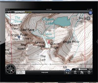
BACKPACKER Map Maker
iPad
Our updated trip-planning app includes Map Packs, which make saving topos for off-the-grid use a breeze (Pro version), plus the ability to design, size, and one-click order a custom, waterproof myTopo map (Pro and Lite). Users still rave about dual mode, which blends seven seamless basemap options (including 68,000 topos in the US and Canada). Cloud power: Sync trips and follow with GPS Trails, our app for iPhone or Android. Lite: free; Pro: $5; backpacker.com/mapmaker