Zion National Park: Zion Narrows of the Virgin River

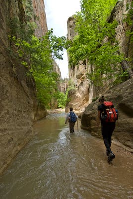
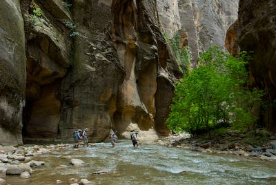
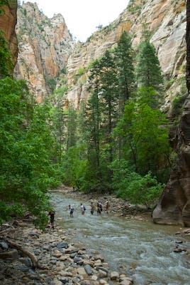
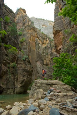
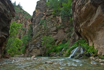
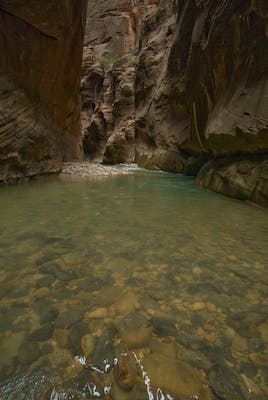
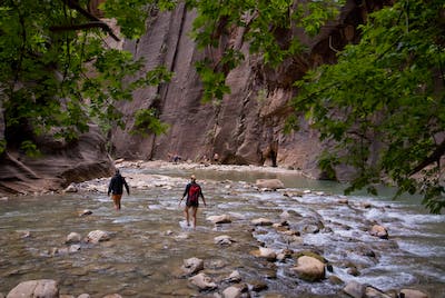
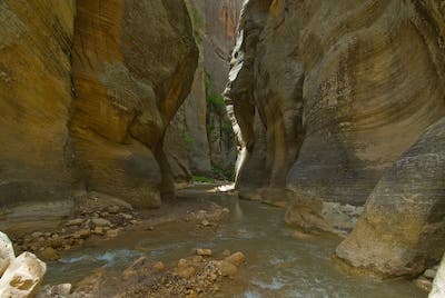
This justly renowned hike consists of a clear, swift stream running through a 2,000-foot-deep sandstone gorge. Quiet side canyons, striking glades of maple and ponderosa, and lush hanging gardens of monkeyflower make it a must-do for fit hikers with strong ankles and knees. From mile 3 to mile 15, you’ll be mostly wading through water and over slick ‘bowling ball’ rocks. This is not a trail hike, and expect to get wet up to your waist often.
The Narrows can be trekked as a long dayhike, or an overnight (recommended). If done as a dayhike, you’ll need to start early and travel fast to Mile 10. Below there, the route gets rougher, deeper, and much slower. Many overconfident hikers find themselves struggling to finish in deep water, near-darkness, and chilly evening temperatures. Note: Campfires are prohibited in the Zion Narrows.
TRIP BASICS:
• Hike quickly from the Chamberlin Ranch trailhead (ZNR001) to Mile 3 (ZNR006). Taking the graded road south of the river keeps your shoes dry to this point. Then it’s time to wade.
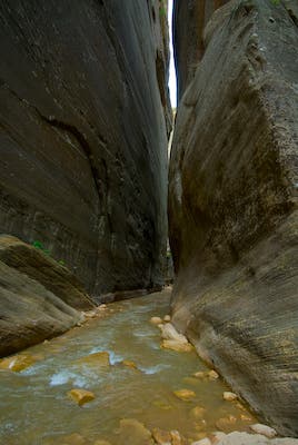
• Tight narrows begin at Mile 6.45 (ZNR008). Get your river fording skills down between here and the Deep Creek Confluence at mile 8.66 (ZNR014). Deep Creek triples the water volume, making for deeper crossings and more powerful currents.
• Below the Goose Creek confluence Mile 10.68 (ZNR021) deep pools, steep dirt detour trails, and slick downclimbs make travel very slow to Big Springs at Mile 11.31 (ZNR025).
• Below Big Springs you’ll be continually in water for the next two miles, until the Orderville Canyon confluence at Mile 13.33 (ZNR029). The long, straight hallways may require swimming.
• Below Orderville, day hikers crowd the canyon, lessening it’s appeal, but travel is much easier, and swifter.
GEAR UP: You’ll want sticky-soled shoes, preferably mid-height or taller, and a walking stick or trekking poles for stability and pool probing. A ‘farmer John’ wetsuit is advisable for shoulder season travel. Your pack should be totally waterproofed with trash bags or a solid pack liner. Double-bag your sleeping bag. Quick-dry shorts work work well for most seasons. Bring an extra dry shirt, an extra synthetic sweater, and a rain shell, even in the hottest weather. Shade, wet clothing, and canyon winds can be surprisingly cold. Thunderstorms can make the canyon frigid. You can rent specialty items in Springdale at the Zion Adventure Company.
WHEN TO GO: The best season is from May through October. Continual water makes this a fine hike even in oven-hot weather. In mid-summer the water will rarely be more than knee deep. In spring, much of it is thigh deep, and several sections may require swimming. Our author scouted this trip in early June at a flow of roughly 90 cubic feet per second. Water level details on the waypoints are described for those conditions. Check out the Virgin River Flow Gauge and play around with graph parameters.
WEATHER: Watch the current weather forecast. The Narrows migh suddenly close due to high water or flash flood danger. Permits are not issued when flows exceed 120 cfs. Under normal conditions, the Narrows is a fun, safe, athletic hike, but conditions mean everything. Whitewater kayakers occasionally paddle the Narrows in spring run-off on flows between 400 and 600 cfs. It is a very dangerous Class V river under such conditions, with raging currents, numerous logjams, boulder piles, and a blind 20-foot waterfall. In May 2009, four out of five kayak parties required helicopter rescue during flows around 500 cfs. Rains often create similar, temporary flows. If high water strands you in the Narrows during a hike, do not attempt to travel until water levels drop.
PERMIT: The park requires permits for all thru-hikes, whether day or overnight. With your permit you’ll receive a canyon map, and a pooh bag (double layer metallic ziploc) for each person. For fees and more info, go to nps.gov/zion/planyourvisit/backcountry-reservations-and-permits.htm
SHUTTLES: Zion Adventure Company (435) 772-0990; Zion Rock & Mountain Guides (435) 772-3303; Red Rock Shuttle & Tours (435) 635-9104.
-Mapped by Steve Howe
TO TRAILHEAD: Drive from Salt Lake City or Las Vegas via I-15 and UT 9 to the town of Springdale. While you can do the shuttle to Chamberlin Ranch trailhead on your own, it is long and slow. Three outfitters run commercial shuttles for $35/person, the preferred option. If dayhiking, take the early (6:30 a.m.) shuttles. From trip’s end at the Temple of Sinawava parking lot, take the free park shuttle bus to the Visitor Center, then transfer to the Springdale town
shuttle. This will return you to your car at whatever shuttle company you used.
PRO Trip Info
CONTACT
Zion National Park
(435) 772-3256
nps.gov/zion
WHERE TO STAY
Zion Lodge
Located on Zion Canyon Scenic Drive. Open year-round. Motel rooms, cabins, and suites available. Also has a gift shop and post office. Reservations recommended: 888-297-2757; zionlodge.com
Camping
South Campground: First-come, first-served. 435-772-3256
Watchman Campground: Reservations can be made six months prior to arrival date at recreation.gov; 877-444-6777
WHERE TO EAT
Red Rock Grill Dining Room at Zion Lodge
Open year round. Dinner reservations advised spring through fall: 435-772-3213.
Castle Dome Cafe at Zion Lodge
Open seasonally.
Whiptail Grill
445 Zion Park Boulevard
Springdale, UT 84737
(435) 772-0283
GROCERIES
Sol Foods
95 Zion Park Boulevard
Springdale, UT 84737
(435) 772-0277
Lin’s Marketplace
1120 W State St
Hurricane, UT
(435) 635-4477
GAS
Honey’s Fuel Center
344 South 350 East
Kanab, UT 84741-3739
(435) 644-2736
Walker’s
1180 W State St
Hurricane, UT 84737
(435) 635-7529
Trail Facts
- Distance: 25.7
Waypoints
ZNR001
Location: 37.384665, -112.838934
Chamberlain Ranch Trailhead. Private land. No camping. Follow user trail, or dirt road, your choice.
ZNR002
Location: 37.378739, -112.848987
0.89 Mi. Fence. Go thru.
ZNR003
Location: 37.376067, -112.858509
1.49 Miles. Strike road again. Follow West/downcanyon.
ZNR004
Location: 37.372791, -112.864026
2.07 Miles. Leave road, descend to river and follow old ATV track.
ZNR005
Location: 37.371231, -112.866316
Bulloch’s Cabin. Old pioneer ranch ruin in field 200 yards south of trail.
ZNR006
Location: 37.371088, -112.879084
3.0 Miles. End of vehicle tracks. Cliff-to-cliff water begins.
ZNR007
Location: 37.370152, -112.882831
3.25 Miles. Wilderness Study Area boundary sign.
ZNR008
Location: 37.37099, -112.923573
6.45 Miles. Deep, tight narrows begin. Sections only 20 feet wide.
ZNR009
Location: 37.370636, -112.926368
6.63 Miles. Second tight narrows section.
ZNR010
Location: 37.368838, -112.930093
6.92 Miles. First obvious side canyon on river right.
ZNR011
Location: 37.367744, -112.931249
7.03 Miles. NPS Campsite #1. Among pines on riverside bench. River left.
ZNR012
Location: 37.36596, -112.937446
7.47 Miles. 20-foot-high waterfall over logjam. Detour by climbing left/South through crack behind house-sized boulder.
ZNR013
Location: 37.365994, -112.938666
7.55 Miles. Rugged boulder pile requires extensive clambering.
ZNR014
Location: 37.359376, -112.951983
8.66 Miles. Deep Creek Confluence. NPS campsites #2 & #3 in immediate area. Flow from Deep Creek triples water volume. Lovely but tough travel upstream into Deep Creek.
ZNR015
Location: 37.355209, -112.951701
8.95 Miles. NPS Campsite 4. Not very nice. Trail runs right through site.
ZNR016
Location: 37.352319, -112.949713
9.23 Miles. NPS Campsite 5. Aesthetic but small. Room for 2. Can camp on large flat boulder overlooking river. Limited weather shelter from overhang at cliff.
ZNR017
Location: 37.35019, -112.949825
9.39 Miles. NPS Campsite 6.
ZNR018
Location: 37.348638, -112.951557
9.56 Miles. NPS Campsite 7
ZNR019
Location: 37.344027, -112.951911
10.0 Miles. NPS Campsite 8.
ZNR020
Location: 37.339688, -112.95541
10.45 Miles. Campsite 9
ZNR021
Location: 37.337998, -112.956016
10.68 Miles. Many deep pools with steep dirt detour trails and boulder scrambles in between. Slow travel to Big Spring.
ZNR022
Location: 37.337259, -112.955729
10.72 Miles. NPS Campsite #10. Overhanging wall provides rain shelter. Open, ‘mountain valley’ feel to canyon.
ZNR023
Location: 37.334648, -112.955559
10.94 Miles. NPS Campsite #11. Nice, open campsite with ‘timbered mtn valley’ feel. More alpine, less gloomy than narrower campsites.
ZNR024
Location: 37.332587, -112.956508
11.13 Miles. NPS campsite #12. Group campsite for 12 people max. Hidden off-trail on bench to river left.
ZNR025
Location: 37.33104, -112.956874
11.31 Miles. Big Spring. Rushing waterfall spring with hanging gardens of monkeyflower. Canyon gets narrower and water deeper from here to Orderville.
ZNR026
Location: 37.329188, -112.957357
11.49 Miles. Long straight hallway with deep water throughout. May require swimming through mid-June of average run-off year – or after significant rains.
ZNR027
Location: 37.318008, -112.951942
12.41 Miles. Second deep water section. Boulders in sandy streambed form deep pits you may have to swim around.
ZNR028
Location: 37.309662, -112.949231
13.08 Miles. Imlay Canyon confluence is invisible on heights above river. Canyoneers finish this extremely difficult narrows with a 180-foot free rappel to river.
ZNR029
Location: 37.307881, -112.946776
13.33 Miles. Mouth of Orderville Canyon. You’ll encounter many hikers from here to finish.
ZNR030
Location: 37.299973, -112.944552
14.60 Miles. Deepest water of lower canyon. Waist to chest deep along wall, river right.
ZNR031
Location: 37.299279, -112.944303
14.65 Miles. Mystery Canyon, visible as steep moss-covered slab with waterfall runnel coming down. Canyoneers may be rappelling out.
ZNR032
Location: 37.293947, -112.948327
15.17 Miles. Sandstone rock wall signals beginning of asphalt tourist trail to Temple of Sinawava.
ZNR033
Location: 37.285201, -112.947735
15.95 Miles. END. Temple of Sinawava shuttle bus stop and parking lot.
Upper Canyon
Location: 37.371233, -112.900182
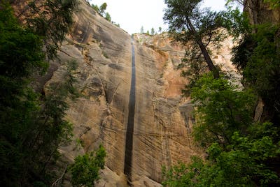
Water streak and desert varnish in upper canyon
Shallow Stream
Location: 37.370107, -112.916619
Typical shallow stream section in upper canyon
First Narrows
Location: 37.370892, -112.924472
First tight narrows.
Deep Creek
Location: 37.359295, -112.951337
Deep Creek confluence.
Below Deep Creek
Location: 37.357521, -112.951466
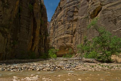
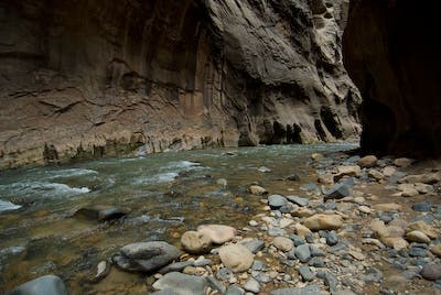
Larger stream in lower canyon below Deep Creek confluence.
Crossing
Location: 37.353189, -112.95138
Group crossing stream above Campsite 5
Campsite 5
Location: 37.352131, -112.949535
Flat Rock at Campsite 5
Big Spring
Location: 37.331387, -112.957088
Big Spring.
Slot View
Location: 37.322855, -112.955114
Orderville Junction
Location: 37.307667, -112.946745
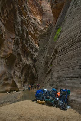
Thru-hiker backpacks stashed at Orderville Junction for side hike.
Small Rapids
Location: 37.306472, -112.947818
Flood Debris
Location: 37.302785, -112.946659
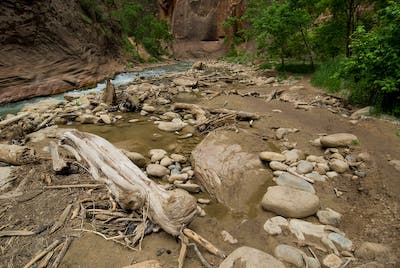
Flash flood debris in lower canyon.
Lower Canyon
Location: 37.298109, -112.946273
Hikers in broad, lower canyon. Can get extremely crowded on weekends and holidays.
Rock Pinch
Location: 37.365912, -112.934085
Below Deep Creek
Location: 37.357521, -112.951466
Larger stream in lower canyon below Deep Creek confluence.
Big Spring
Location: 37.331387, -112.957088
Big Spring.
Campsite 5
Location: 37.352131, -112.949535
Flat Rock at Campsite 5
Crossing
Location: 37.353189, -112.95138
Group crossing stream above Campsite 5
Deep Creek
Location: 37.359295, -112.951337
Deep Creek confluence.
First Narrows
Location: 37.370892, -112.924472
First tight narrows.
Flood Debris
Location: 37.302785, -112.946659
Flash flood debris in lower canyon.
Lower Canyon
Location: 37.298109, -112.946273
Hikers in broad, lower canyon. Can get extremely crowded on weekends and holidays.
Orderville Junction
Location: 37.307667, -112.946745
Thru-hiker backpacks stashed at Orderville Junction for side hike.
Rock Pinch
Location: 37.365912, -112.934085
Shallow Stream
Location: 37.370107, -112.916619
Typical shallow stream section in upper canyon
Slot View
Location: 37.322855, -112.955114
Small Rapids
Location: 37.306472, -112.947818
Upper Canyon
Location: 37.371233, -112.900182
Water streak and desert varnish in upper canyon
ZNR001
Location: 37.384665, -112.838934
Chamberlain Ranch Trailhead. Private land. No camping. Follow user trail, or dirt road, your choice.
ZNR002
Location: 37.378739, -112.848987
0.89 Mi. Fence. Go thru.
ZNR003
Location: 37.376067, -112.858509
1.49 Miles. Strike road again. Follow West/downcanyon.
ZNR004
Location: 37.372791, -112.864026
2.07 Miles. Leave road, descend to river and follow old ATV track.
ZNR005
Location: 37.371231, -112.866316
Bulloch’s Cabin. Old pioneer ranch ruin in field 200 yards south of trail.
ZNR006
Location: 37.371088, -112.879084
3.0 Miles. End of vehicle tracks. Cliff-to-cliff water begins.
ZNR007
Location: 37.370152, -112.882831
3.25 Miles. Wilderness Study Area boundary sign.
ZNR008
Location: 37.37099, -112.923573
6.45 Miles. Deep, tight narrows begin. Sections only 20 feet wide.
ZNR009
Location: 37.370636, -112.926368
6.63 Miles. Second tight narrows section.
ZNR010
Location: 37.368838, -112.930093
6.92 Miles. First obvious side canyon on river right.
ZNR011
Location: 37.367744, -112.931249
7.03 Miles. NPS Campsite #1. Among pines on riverside bench. River left.
ZNR012
Location: 37.36596, -112.937446
7.47 Miles. 20-foot-high waterfall over logjam. Detour by climbing left/South through crack behind house-sized boulder.
ZNR013
Location: 37.365994, -112.938666
7.55 Miles. Rugged boulder pile requires extensive clambering.
ZNR014
Location: 37.359376, -112.951983
8.66 Miles. Deep Creek Confluence. NPS campsites #2 & #3 in immediate area. Flow from Deep Creek triples water volume. Lovely but tough travel upstream into Deep Creek.
ZNR015
Location: 37.355209, -112.951701
8.95 Miles. NPS Campsite 4. Not very nice. Trail runs right through site.
ZNR016
Location: 37.352319, -112.949713
9.23 Miles. NPS Campsite 5. Aesthetic but small. Room for 2. Can camp on large flat boulder overlooking river. Limited weather shelter from overhang at cliff.
ZNR017
Location: 37.35019, -112.949825
9.39 Miles. NPS Campsite 6.
ZNR018
Location: 37.348638, -112.951557
9.56 Miles. NPS Campsite 7
ZNR019
Location: 37.344027, -112.951911
10.0 Miles. NPS Campsite 8.
ZNR020
Location: 37.339688, -112.95541
10.45 Miles. Campsite 9
ZNR021
Location: 37.337998, -112.956016
10.68 Miles. Many deep pools with steep dirt detour trails and boulder scrambles in between. Slow travel to Big Spring.
ZNR022
Location: 37.337259, -112.955729
10.72 Miles. NPS Campsite #10. Overhanging wall provides rain shelter. Open, ‘mountain valley’ feel to canyon.
ZNR023
Location: 37.334648, -112.955559
10.94 Miles. NPS Campsite #11. Nice, open campsite with ‘timbered mtn valley’ feel. More alpine, less gloomy than narrower campsites.
ZNR024
Location: 37.332587, -112.956508
11.13 Miles. NPS campsite #12. Group campsite for 12 people max. Hidden off-trail on bench to river left.
ZNR025
Location: 37.33104, -112.956874
11.31 Miles. Big Spring. Rushing waterfall spring with hanging gardens of monkeyflower. Canyon gets narrower and water deeper from here to Orderville.
ZNR026
Location: 37.329188, -112.957357
11.49 Miles. Long straight hallway with deep water throughout. May require swimming through mid-June of average run-off year – or after significant rains.
ZNR027
Location: 37.318008, -112.951942
12.41 Miles. Second deep water section. Boulders in sandy streambed form deep pits you may have to swim around.
ZNR028
Location: 37.309662, -112.949231
13.08 Miles. Imlay Canyon confluence is invisible on heights above river. Canyoneers finish this extremely difficult narrows with a 180-foot free rappel to river.
ZNR029
Location: 37.307881, -112.946776
13.33 Miles. Mouth of Orderville Canyon. You’ll encounter many hikers from here to finish.
ZNR030
Location: 37.299973, -112.944552
14.60 Miles. Deepest water of lower canyon. Waist to chest deep along wall, river right.
ZNR031
Location: 37.299279, -112.944303
14.65 Miles. Mystery Canyon, visible as steep moss-covered slab with waterfall runnel coming down. Canyoneers may be rappelling out.
ZNR032
Location: 37.293947, -112.948327
15.17 Miles. Sandstone rock wall signals beginning of asphalt tourist trail to Temple of Sinawava.
ZNR033
Location: 37.285201, -112.947735
15.95 Miles. END. Temple of Sinawava shuttle bus stop and parking lot.