Published September 20, 2013 02:28PM
Yosemite National Park: Half Dome
Climb 4,800 feet on this classic 15.7-mile route to the top of the park’s most-iconic peak towering above the Valley floor.
Go south from Happy Isles (4,035 ft.) along Merced River and wrap around Sierra Point; to the west, see tendrils of Illilouette Falls tumbling through a steep-walled gorge. Ahead, cross footbridge; sheets of whitewater flow over Vernal Falls. Take a right onto the John Muir Trail (JMT) and climb to Clark Point for view slight views back into Yosemite Valley and Half Dome’s south flank.
Stay with the JMT and cross a bridge over roaring Nevada Falls and look over to the bleached granite knob of Liberty Cap. Continue toward Little Yosemite Ranger Station and ahead, make a decision: either go left onto the JMT for Half Dome (4 hours) or go right to camp in Little Yosemite Valley (permit required) for an early start and a cherry-red sunrise tomorrow.
ADVERTISEMENT
If continuing, take a left onto the Half Dome Trail at the 7,020-foot mark and head up tight switchbacks to the foot of the cables. When you reach the base of the cables, grab gloves and get in line for the cable-aided final climb over airy slabs. Warning: If thunderheads loom, abort and go back. Once you’ve crested the final cables, enjoy the summit where a non-stop 360° from Half Dome (8,836 ft.) to the Sierra crest opens up.
Check out El Capitan towering to the west across the Valley. Take hero shots and rest up before then backtracking to waypoint #6 for the return on the Mist Trail past Vernal Falls and Merced River. Close the loop at waypoint #3 and retrace to Happy Isles. -Mapped by Andrew Matranga
PLAN IT
GUIDEBOOK AND MAP: The Complete Guidebook to Yosemite National Park, 6th Edition ($12.95, yosemitegifts.com).
CONDITIONS: For current conditions, go to nps.gov/yose/planyourvisit/conditions.htm.
PERMIT: A permit is required to hike the cables on Half Dome. A maximum of 400 permits will be issued each day (300 are available to dayhikers). Overnight camping also requires a backcountry permit. For details, go to nps.gov/yose/planyourvisit/hdpermits.htm.
MORE PARK INFO: Yosemite National Park, 209-372-020; nps.gov/yose
FREE TRIP PLANNERS Get news on vacation deals and lodging at myyosemitepark.com
GAS
Lee Vining: Chevron
51557 Highway 395
Lee Vining, CA 93541
760-647-6330
Groveland: Claim Jumper Outpost
17586 Highway 120
Groveland-Big Oak Flat, CA 95305
209-962-7153
GEAR
Mammoth Mountaineering Supply
3189 Main St.
Mammoth Lakes, CA 93546
888-395-3951
GROCERIES
Mammoth Lakes: Vons
481 Old Mammoth Rd.
Mammoth Lakes, CA;
760-934-4536
RESTAURANTS
Mammoth Lakes: Angel’s Restaurant
20 Sierra Blvd.
Mammoth Lakes, CA 93546
760-934-7427
Curry Village: Degnan’s Deli
9015 Village Dr.
Curry Village, CA 95389
290-372-8454
Groveland: Cafe Charlotte
18736 Main St.
Groveland, CA 95321
209-962-6455
Lee Vining: Nicely’s Restaurant
Highway 395 and 4th St.
Lee Vining, CA 93541
760-647-6477


ADVERTISEMENT
Trail Facts
- Distance: 25.3
Waypoints
HDT001
Location: 37.73385, -119.558021
ADVERTISEMENT
Go S from Happy Isles (4,035 ft.) along Merced River and wrap around Sierra Point; to W, see tendrils of Illilouette Falls
HDT002
Location: 37.726381, -119.552289
Cross footbridge; sheets of whitewater flow over Vernal Falls
HDT003
Location: 37.726203, -119.548835
R @ Y onto John Muir Trail (JMT)
HDT004
Location: 37.724998, -119.544899
Clark Point: slight views back into Yosemite Valley and S side of Half Dome. Keep R on JMT
HDT005
Location: 37.722481, -119.535004
Stay R on JMT; cross bridge over roaring Nevada Falls and look over to the bleached granite knob of Liberty Cap
HDT006
Location: 37.726143, -119.530392
Head R and cross river
HDT007
Location: 37.730691, -119.52256
R toward Little Yosemite Ranger Station
HDT008
Location: 37.732182, -119.5158
Two choices here: L @ Y on JMT for Half Dome (4 hours). Or R to camp @ Little Yosemite Valley (permit required) for an early start and a cherry-red sunrise tomorrow
HDT009
Location: 37.745365, -119.513016
L @ Y to Half Dome Trail (7,020 ft.)
HDT010
Location: 37.748301, -119.527334
Tight switchbacks
HDT011
ADVERTISEMENT
Location: 37.746566, -119.530279
Grab gloves and get in line for the cable-aided final climb over airy slabs. Warning: If thunderheads loom, abort and go back
HDT012
Location: 37.745828, -119.533364
Pan 360° for nonstop views from Half Dome (8,836 ft.), then backtrack to WPT 6 and turn R onto Mist Trail
HDT013
Location: 37.726681, -119.541603
L @ Y, staying on Mist Trail past Vernal Falls and Merced River. Rainbows likely. Close loop @ WPT 3 and retrace to Happy Isles
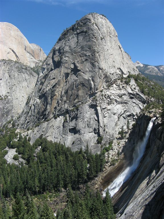
Liberty Cap and Nevada Falls
Location: 37.722528, -119.534683
The John Muir Trail provides a bird’s-eye vantage over the churning torrent of Nevada Falls. Liberty Cap and Half Dome’s south face frame the view.
Liberty Cap and Half Dome
Location: 37.724514, -119.533138
Descending on the John Muir Trail, you’ll get near-constant views over Half Dome’s bare south face and the sharp slope of Liberty Cap.
Half Dome
Location: 37.751105, -119.521229
ADVERTISEMENT
As the trees thin, even better views of Half Dome emerge.
The Icon
Location: 37.750799, -119.521669
Nearing the saddle, check a first glimpse of the hike’s goal: the rounded summit of Half Dome.
The Cables
Location: 37.745925, -119.531915
Andrew Matranga ascends the famed cables of Half Dome’s east face.
Summit Sunrise
Location: 37.745768, -119.532398
Andrew Matranga reaches the top of the cables just as the morning sun casts a peach glow over the exfoliated summit of Half Dome.
Empty Summit
Location: 37.745713, -119.53353
Wake up early, and you’ll have the entire summit to yourself, a rarity in one of America’s crown-jewel parks.
Views of the High Sierra
Location: 37.745582, -119.533637
From the summit, gaze into Little Yosemite Valley and the Sierra Crest in the background. Quarter Dome, Clouds Rest, and other features dominate the foreground.
The Summit
Location: 37.745455, -119.533702
The bare expanse of Half Dome before the crowds arrive.
Vertigo
Location: 37.745535, -119.533476
ADVERTISEMENT
A hiker stands at the lip of a many thousand-foot fall into the valley. Not for the faint of heart or scared of heights.
Valley View
Location: 37.745671, -119.53338
The first light of day casts shadows over the floor of Yosemite Valley, 4,800 feet below. The sheer wall in the center of the frame is the famed El Capitan.
Down the Cables
Location: 37.745781, -119.532613
The view down the cables. These wires and planks do sway with wind and hiker’s weight. Take caution when on this route.
Descending Half Dome
Location: 37.745836, -119.53213
Head down the cables.
Descent
Location: 37.74668, -119.530107
A hiker finishes descending the cable route.