Published September 19, 2013 11:20PM
Yosemite National Park: Elizabeth Lake
Climb through deep lodgepole forest toward the foot of the Cathedral Range on this 4-mile out-and-back to the peaceful Elizabeth Lake.
Gain front-row access to the hulking Cathedral Range from the shores of pristine Elizabeth Lake on this jaunt through the conifer-blanketed hillsides south of Tioga Road. Starting at the trailhead near Loop B of the Tuolumne Meadows Campground, duck into the woods and head south until reaching a four-way intersection. Pick up the middle fork, which will carry you all the way to the lake. The trail begins climbing uphill at a gentle grade, weaving through a deep, boulder-dotted forest of lodgepole pine and mountain hemlock. Just past mile 0.5, the grade intensifies (you’ll gain nearly 400 feet in elevation before breaking into a clearing at mile 1.3) as the trail becomes rocky and root-crossed.
As the forest thins out, the trail breaks into a lush green meadow divided by the babbling, rock-dotted Unicorn Creek, which funnels water from Elizabeth Lake into the dense lodgepole kingdom below. Just before reaching Elizabeth’s grass-tufted eastern shore, the trail crosses a junction featuring a series of social trails: the right fork offers the quickest access to the lake. Several broad granite slabs, perfect for sunbathing, are plunked into the clear, shallow water just off Elizabeth’s eastern shore.
Using a social trail following the lake’s grass-brushed northern shore, take a side-trip to a vantage point under Unicorn Peak, which rises prominently above Elizabeth’s western shore. At the base of the granite slopes below the peak, scramble upward for a sublime panorama of the lake back-dropped by the burly Johnson Peak. From a bit higher, Ragged Peak also breaks into the picture on the northern skyline. After satisfying your appetite for exploration, use the route you came in on to return to the trailhead.
PLAN IT
GUIDEBOOK AND MAP The Complete Guidebook to Yosemite National Park, 6th Edition ($12.95, yosemitegifts.com). Consult the time-tested authority on Yosemite, or plan other trips in the park using BACKPACKER’s Destination’s page (backpacker.com/destinations/category/206). Get around the park using Yosemite’s free shuttle service (nps.gov/yose/planyourvisit/upload/valleyshuttle.pdf).
FEES/PERMITS To enter park: $20 per car, $10 per pedestrian/ bicyclist. Pass is valid for seven days. Backcountry permits are required for all overnight stays from May through October. Reservations for a permit can be obtained no earlier than 24 weeks before the first night of your stay. Permits cost $5 per reservation and $5 per person in the party. Depending on availability, permits can also be obtained at the wilderness center on the day of your trip.
ADVERTISEMENT
CONTACT Call the Wilderness Permit Office at (209) 372-0740; nps.gov/yose/planyourvisit/wildpermits.htm
CONDITIONS Tioga Pass Road (Highway 120) is closed between October and May. Water is available along the trail at mile 2.8, mile 3.8, mile 5.4 (seasonal), mile 7.9, mile 11.7, mile 13, and mile 14.4.
GPS DATA Download tracks and waypoints, print or order custom topos, from the menu on the left.
LOCAL LINKS
GAS
LEE VINING: CHEVRON
51557 Highway 395
Lee Vining, CA 93541
(760) 647-6330
GROVELAND: CLAIM JUMPER OUTPOST
17586 Highway 120
Groveland-Big Oak Flat, CA 95305
(209) 962-7153
GEAR
MAMMOTH MOUNTAINEERING SUPPLY
3189 Main St.
Mammoth Lakes, CA 93546
(888) 395-3951
GROCERIES
EL PORTAL: EL PORTAL MARKET
10913 Highway 140
El Portal, CA 95318
(209) 379-2700
MAMMOTH LAKES: VONS
481 Old Mammoth Rd.
Mammoth Lakes, CA
(760) 934-4536
RESTAURANTS
MAMMOTH LAKES: ANGEL’S RESTAURANT
20 Sierra Blvd.
Mammoth Lakes, CA 93546
(760) 934-7427
CURRY VILLAGE: DEGNAN’S DELI
9015 Village Dr.
Curry Village, Yosemite National Park, CA 95389
(290) 372-8454
LEE VINING: NICELY’S RESTAURANT
Highway 395 and 4th St.
Lee Vining, CA 93541
(760) 647-6477
EL PORTAL: YOSEMITE VIEW RESTAURANT
11156 Highway 140
El Portal, CA 95318
(209) 379-2681
-Text: Brian Beer. Map and photographs: Jeff Chow


ADVERTISEMENT
Trail Facts
- Distance: 6.4
Waypoints
ELL001
Location: 37.870907, -119.356241
ADVERTISEMENT
Follow signs to the Tuolumne Meadows Campground (south of CA 120, 19 miles west of the junction with US 395). Snag a parking pass and map at the campground entrance to navigate to the well-marked trailhead (sandwiched between Loop B and the Horse Camp, next to the restrooms). Begin by entering the forest and heading south. At the four-way intersection, follow the middle fork all the way to Elizabeth Lake.
ELL002
Location: 37.857483, -119.361667
Cross Unicorn Creek while meandering uphill.
ELL003
Location: 37.854035, -119.363677
The trail levels as the forest opens up. In the fall, crimson vegetation adorns the banks of Unicorn Creek.
ELL004
Location: 37.846783, -119.365017
Just before reaching Elizabeth, you’ll reach a web of trails. Bear right to pick up the most direct route to the lake. The trail crosses over Unicorn Creek, Elizabeth’s gurgling outlet stream.
ELL005
Location: 37.846463, -119.367152
Reach Elizabeth Lake’s northeastern corner. Cockscomb is visible immediately to the southwest, while Unicorn Peak rises in front Cathedral Peak rises to the west. Cathedral Peak looms to the southeast.
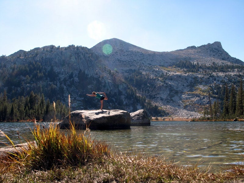
Elizabeth Lake
Location: 37.846451, -119.367317
Studded with flat granite slabs and bordered by majestic granite peaks, Elizabeth Lake inspires visitors to break into celebratory yoga poses.
Tuolumne River
Location: 37.876107, -119.355083
On your approach to the trailhead, you’ll cross the Tuolumne River on Tioga Pass Road.
ADVERTISEMENT
Reflections
Location: 37.8763, -119.354783
From Tioga Pass Road, enjoy immaculate reflections of the Cathedral Range in the Tuolumne River’s still water.
Trail Sign
Location: 37.8698, -119.355917
At a four-way junction, you’ll reach this sign. Take the middle fork all the way to Elizabeth Lake.
Heading South
Location: 37.8542, -119.3636
The well-defined trail is lined with lodgepole pine and a carpet of delicate, low-lying vegetation.
Clearing
Location: 37.855017, -119.363233
At mile 1.3, the forest opens up as the trail levels.
Fall Colors
Location: 37.8542, -119.3636
The lodgepole pines comprising much of Yosemite’s woodlands stay green through the year, but plantlife on the forest floor explodes with color during fall.
Mule Deer
Location: 37.84585, -119.367313
Mule Deer wander the shoreline of Elizabeth Lake.
Elizabeth Lake
Location: 37.846451, -119.367317
Nestled under the shadow of Unicorn Peak and the Cockscomb, Elizabeth Lake serves up front-row vistas of the Cathedral Range.