Yellowstone National Park: Terrace Mountain Loop via Glen Creek

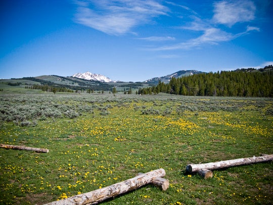
Views along this 7-mile loop are impressive right from the parking lot. Take in majestic meadows rimmed by the distant Gallatin Range before starting your hike from the Glen Creek Trailhead. The first few miles of this easy-to-follow path run along the base of Terrace Mountain, paralleling the curves of the Glen Creek. Watch for elk and bison while meandering along a wildflower-lined path en route to the northern flank of Terrace Mountain.
After 2.3 miles, the route turns east at a 3-way junction and climbs to the top of Snow Pass, a narrow saddle pinched between Terrace Mountain and Clagett Butte. After cresting the pass, the trail drops into an unnamed creek valley above Pinyon Terrace, then rounds to the south along Terrace Mountain’s eastern edge.
Finish the hike by taking in more views of the surrounding mountains and checking out the Hoodoos, a wonderland of boulders and rock pillars. After the Hoodoos, pass through a burned section of forest and close the loop at Waypoint 2. Turn left for the 0.2-mile trip back to the trailhead.
MORE PARK INFO: Yellowstone National Park, (307) 344-7381; nps.gov/yell/.
-Mapped by Jason Kauffman


Trail Facts
- Distance: 11.3
Waypoints
GLE001
Location: 44.9312849, -110.7294792
Glen Creek Trailhead: Head northwest on the trail as it follows Glen Creek.
GLE002
Location: 44.9335825, -110.7318288
Turn left at 3-way junction with Howard Eaton Trail. Snow-covered Electric Peak, the tallest mountain in the Gallatin Range, can be seen in the distance.
GLE003
Location: 44.9443205, -110.7417104
The trail climbs to a grassy bench with excellent views to the northwest of the Gallatin Range.
GLE004
Location: 44.9476243, -110.7431531
Enters a creek valley surrounded by rolling grass and forest-covered slopes. Watch for signs of elk and bison.
GLE005
Location: 44.9561738, -110.7452774
Bear left at Y-junction.
GLE006
Location: 44.9575328, -110.7464147
Continue straight @ 3-way junction toward the opposite side of the large grassy meadow.
GLE007
Location: 44.9595447, -110.748024
Turn right (east) at Y-junction, and follow the edge of the slope to Snow Pass.
GLE008
Location: 44.9594308, -110.7371128
Trail crests Snow Pass and begins to drop into an unnamed creek valley. Clagett Butte rises on the left (this butte was named for Montana Congressman William Clagett, who introduced legislation in 1871 to make Yellowstone the country’s first national park).
GLE009
Location: 44.9599981, -110.7301643
Hike through a dense forest of aspen and mixed conifers.
GLE010
Location: 44.9606986, -110.7280576
Veer right at the Y-junction.
GLE011
Location: 44.9592116, -110.7150468
Take a hard right at Y-junction. Begin a gradual climb back to the Glen Creek Trailhead.
GLE012
Location: 44.9583801, -110.71613
Cut across a small meadow ringed by lovely aspen trees; a perfect spot for lunch.
GLE013
Location: 44.9491733, -110.7192707
Admire the five-star views of Bunsen Peak’s rocky slopes and the surrounding mountains. Pace yourself along this steeper section of trail that leads southwest toward The Hoodoos.
GLE014
Location: 44.9447637, -110.7239072
Skirt the western edge of The Hoodoos, a fantastic wonderland of boulders and large rock pillars.
GLE015
Location: 44.9376534, -110.7233691
Trail passes through forest burned by wildfire. Look for the signs of how quickly the forest is regenerating.
View of Glen Creek
Location: 44.931995, -110.7286692
Near Glen Creek Trailhead
Location: 44.9332824, -110.7314372
Meadow Vallley
Location: 44.951922, -110.744977
Trail enters a lovely meadow valley hidden from the highway.
Aspen Grove
Location: 44.9591878, -110.7149041
Mount Evert and Blacktail Plateau
Location: 44.9518005, -110.7171249
Views of Bunsen Peak
Location: 44.9486418, -110.7194102