Published September 20, 2013 05:26AM
Yellowstone National Park: Phantom Fumarole
Visit a remote, backcountry thermal vent that steams up from the Pitchstone Plateau on this 9.4-mile out-and-back in Yellowstone National Park.
One of Yellowstone National Park’s lesser-traveled routes, this 9.4-mile backcountry trek travels through young lodgepole forests to Phantom Fumarole—a steaming vent on the Pitchstone Plateau. From the trailhead, hike northwest toward the base of the plateau. After a flat, 200-foot stretch, the trail’s steepest section of climbing begins: you’ll gain 500 feet in half a mile.
At the top of the climb, the trail winds west, passing lodgepole forests burned during the 1988 wildfires (many of the new trees are 8 to 10 feet tall) and the glassy, black volcanic rocks that give Pitchstone Plateau its name. After 2.3 miles, hike across the first of several conifer-ringed meadows that dot the route. From here, it’s another 2.3 miles to the steaming pools of Phantom Fumarole. Study the scorched soil for interesting patterns created by the intense subterranean heat, then turn around for the trip back to the trailhead.
ADVERTISEMENT
MORE PARK INFO Yellowstone National Park, (307) 344-7381; nps.gov/yell/
-Mapped by Jason Kauffman


Trail Facts
- Distance: 15.1
Waypoints
PHA001
Location: 44.2432314, -110.647307
Begin a short, but steep climb away from South Entrance Road through unburned lodgepole pine.
PHA002
Location: 44.2441537, -110.6482565
The climb steepens for the next 0.4 mile. (The hike gains most of its elevation here.)
PHA003
Location: 44.2485191, -110.6526661
The trail finally begins to flatten out as portions of the forest opens up. Much of this region was burned during the 1988 wildfires.
PHA004
Location: 44.2485499, -110.6662917
Continue following the faint trail up the washed-out gully.
PHA005
Location: 44.2496028, -110.6718922
Take in lengthy views that extend down-valley to a lush green meadow. To the east, the lower slopes of the Pitchstone Plateau and Mount Sheridan can be seen in the distance; watch for elk that frequent this secluded basin.
PHA006
Location: 44.246865, -110.6837023
The trail enters the first of numerous and steadily larger meadows.
PHA007
Location: 44.2440538, -110.7038641
ADVERTISEMENT
Cross what is usually a dry riverbed.
PHA008
Location: 44.2444996, -110.7100332
Look around for elk and wolves in these conifer-ringed meadows.
PHA009
Location: 44.2438689, -110.7175251
Enter the final meadow before the Phantom Fumarole. On wintry days, watch for steam rising into the cold air (you may also start to smell this thermal feature).
PHA010
Location: 44.241504, -110.7231626
Phantom Fumarole: Look for interesting patterns in the scorched soil created by the intense subterranean heat. Caution: Keep a safe distance from the fumarole’s boiling waters.
Pitchstone Plateau and Mount Sheridan
Location: 44.2495951, -110.6717956
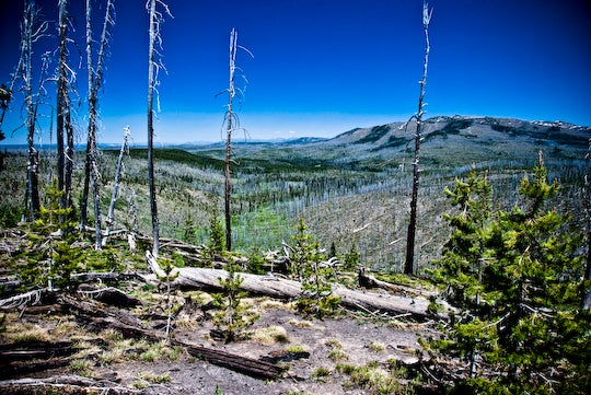
Recovering Forest
Location: 44.2491724, -110.6573761
Much of the trail to Phantom Fumarole passes through the remains of lodgepole pine forests burned during the great fires of 1988.
New Growth
Location: 44.2481695, -110.6784797
New growth on a less than 20-year-old lodgepole pine that sprung up in the wake of the 1988 fires.
Scorched Earth
Location: 44.2419632, -110.7228756
ADVERTISEMENT
The soils around the Phantom Fumarole betray the intensity of the subterranean processes that create this thermal wonder.
Steam from Phantom Fumarole
Location: 44.2415021, -110.723058