Published September 20, 2013 05:39AM
Yellowstone National Park: Osprey Falls
This 8-mile out-and-back in Yellowstone National Park descends a cliffside trail to the base of Osprey Falls, a 150-foot waterfall that pours into Sheepeater Canyon.
Dwarfed in size by only the Grand Canyon of the Yellowstone, Sheepeater Canyon—named for a band of stalwart, sheep-hunting Indians—serves up mind-blowing vistas and access to the magnificent, 150-foot Osprey Falls. The 8-mile trek starts along an abandoned gravel and dirt road, which skirts a meadow where elk often congregate.
After half a mile, the trail begins a moderate but steady climb toward the canyon ridge and the Osprey Falls Trail junction. Along the way, take in dizzying views of Sheepeater Canyon, which plunges 800-feet to the Gardner River, and sweeping panoramas of Gardiner Canyon and the Fort Yellowstone Historic District to the north.
Begin the stiff descent into the canyon at mile 3.2, traversing razor-thin switchbacks often less than one foot wide. After completing this precipitous 0.8-mile stretch of downhill, hike upstream through the canyon to the 150-foot Osprey Falls. The trail ends 30 feet from the falls, but experienced hikers can scramble closer to the base of the falls (use caution navigating the slick rocks). Before starting your return trip, grab a snack in the small cave adjacent to the falls. Follow the same route back to the trailhead.
MORE PARK INFO: Yellowstone National Park, (307) 344-7381; nps.gov/yell/.
-Mapped by Jeff Chow


Trail Facts
- Distance: 12.8
Waypoints
OSP001
ADVERTISEMENT
Location: 44.9566673, -110.7015306
From the parking area, head south on an abandoned road that traces the edge of a meadow; the trail starts to climb in 0.6 mile. The area around Sheepeater Canyon buzzes with wildlife; keep your eyes open for animal tracks (elk, coyote, birds, and rabbits).
OSP002
Location: 44.9482318, -110.6973624
Whet your appetite for Osprey Falls by taking in views of a smaller waterfall to the right of the trail. Ahead: The climb continues.
OSP003
Location: 44.9462461, -110.6915581
From this vantage point, you’ll find northeastern panoramas of the trailhead and the Fort Yellowstone Historic District.
OSP004
Location: 44.945282, -110.690682
Savor sweeping vistas of Gardner Canyon and Fort Yellowstone as the trail switchbacks left and climbs the ridge of Sheepeater Canyon. The canyon gets its name from a band of 300 Western Shoshone Indians, proficient at hunting sheep, that called the rugged canyon their home.
OSP005
Location: 44.9357774, -110.6814301
ADVERTISEMENT
As the trail swings sharply to the right, take in dizzying views of Sheepeater Canyon. Looking north, you’ll catch a glimpse of the serpentine Osprey Falls Trail and the descent ahead. You may spot elk tracks along this stretch. Next, head north on a harrowing trail that runs along a 100-foot precipice.
OSP006
Location: 44.9349648, -110.6841552
Bear left at the Y-junction onto Osprey Falls Trail. Continue tracing the canyon’s edge.
OSP007
Location: 44.929391, -110.684157
Begin your steep descent on a series of razor-thin switchbacks (often one foot wide). Watch your footing here; a fall could result in a long slide down into the canyon.
OSP008
Location: 44.9293537, -110.6804189
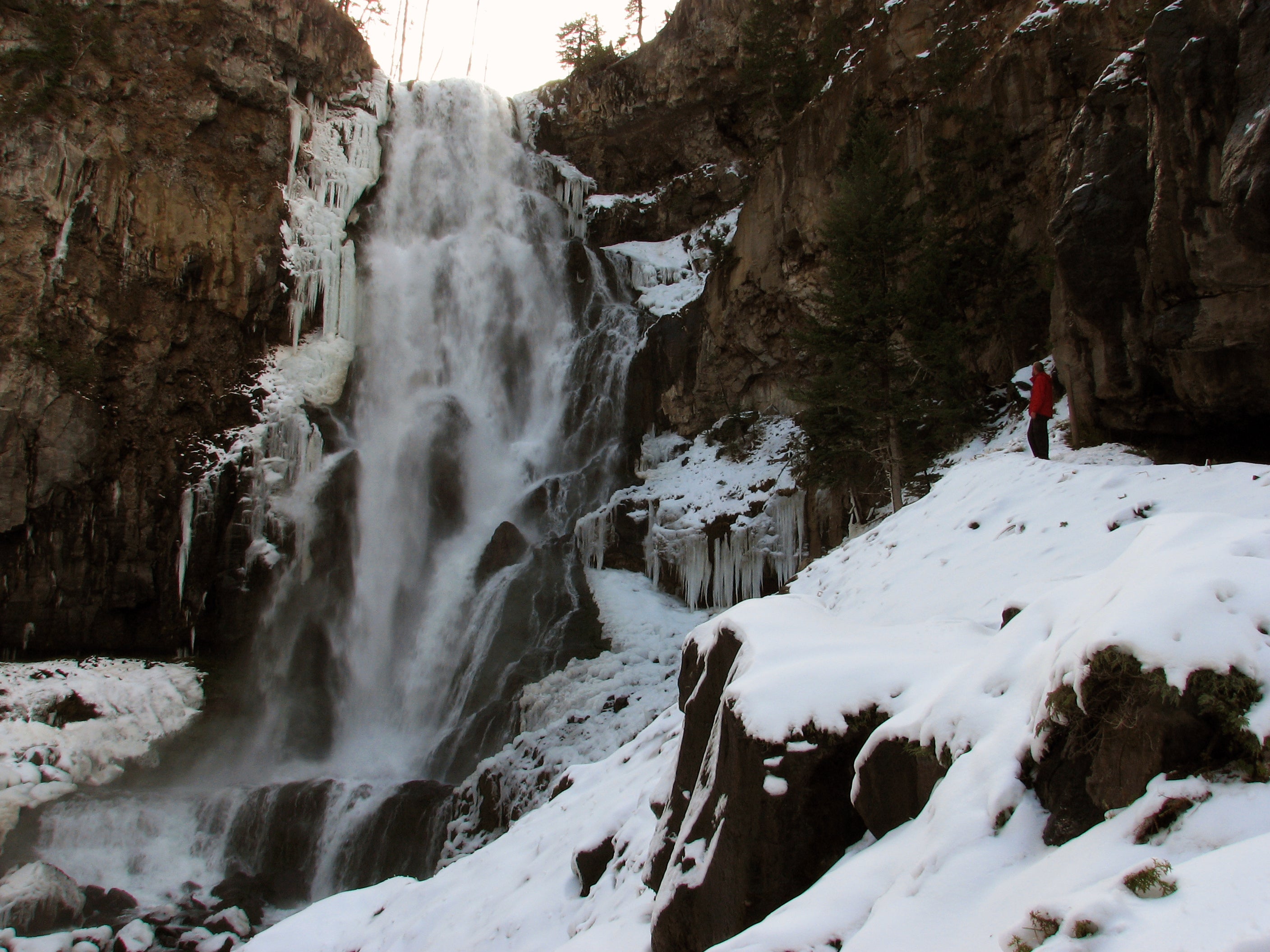
Upon hitting the canyon floor, the trail swings upstream and ends 30 feet before Osprey Falls. Framed by foreboding basalt rock walls, the 150-foot cascade transfers raging torrents of water from the Gardner River into the Sheepeater Canyon below. Adjacent to the falls is a small cave perfect for eating lunch. After getting your fill of Osprey, turn around to tackle the formidable ascent to the top of the canyon and complete the gentle downhill back to the trailhead.
Osprey Falls
Location: 44.929555, -110.680612
ADVERTISEMENT
Though the trail ends 30 feet from the falls, hikers can scramble closer on the broad rocks near the base.
Gravel Road
Location: 44.951667, -110.698343
The trail starts by following an abandoned road now open only to hikers and mountain-bikers.
Small Cascades
Location: 44.94832, -110.697387
This tiny waterfall serves as a tease for the behemoth that lies ahead.
Small Falls
Location: 44.94832, -110.697387
Elk
Location: 44.9459822, -110.6909037
Keep your eyes peeled for the abundance of wildlife the area has to offer.
Trestle
Location: 44.945833, -110.690511
Catch panoramas of a trestle running through the Gardner River Valley.
Mule Deer
Location: 44.94498, -110.689731
Not as common in the park as elk are, mule deer frequent Yellowstone’s open forests and meadows.
Overlook
Location: 44.9357622, -110.6811941
Catch stunning vistas of Sheepeater Canyon as you edge along its high ridges.
Falls
Location: 44.9357395, -110.6811297
Osprey Falls Sign
Location: 44.935377, -110.683927
Head left at the Osprey Falls Trail junction.
Precipice
Location: 44.933313, -110.684253
ADVERTISEMENT
Afraid of heights? Stay well away from the edge of the canyon’s towering ridges.
Sheepeater Canyon
Location: 44.932252, -110.684277
Flanked by majestic, towering rock walls, Sheepeater Canyon plunges more than 800-feet deep in some places.
Looking North Through Sheepeater Canyon
Location: 44.931413, -110.681364
The magnificent canyon opens up to the Gardner River Canyon to the north.
Nearing Osprey Falls
Location: 44.929962, -110.680482
Though less ideal in the winter, the roaring spray from the waterfall offers a perfect cool-down on scorching summer days.
Osprey Falls
Location: 44.9294999, -110.6806147
The falls are flanked by spectacular ice formations in the winter.