Published February 28, 2011 02:40PM
America's Best-Kept Secrets: Wind River Range, WY
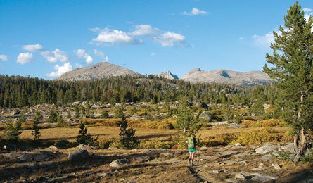
'Sprawling meadows below Timico Lake. (Jonathan Dorn)'
→ In “The Winds,” just as tall as their much-photographed neighbors, but with bigger glaciers and no camping quotas
← OutGrand Teton National Park’s rows of packed campsites in every major canyon
In a range renowned for its incredible peaks-to-people ratio, we’ve scouted the loneliest route of all, in a swath of wild country where lakes sparkle in deep, granite-walled valleys hard up against the rock and ice of the Continental Divide. Begin a loop of 50 miles from Meadow Lake trailhead, south of Pinedale on the west side of the Winds. It’s a hard 12 miles and 2,500 feet to Timico Lake, but the camping is “epic 360-blue-sky-and-toothy-peaks stuff,” says our well-traveled Editor-in-Chief. It’s also a grand introduction because “there are easily a half-dozen views that rank among my lifetime top 50.” From Timico on day two, follow an unofficial use trail two miles to the Divide at 11,280-foot Fall Creek Pass and continue four miles cross-country to Camp Lake—despite the name, don’t camp there. Continue a bit more than a mile to a more ideal site in the 11,000-foot-high, glacially carved valley of the Alpine Lakes, flanked by soaring peaks. From here, dayhike six miles to Alpine Lakes Pass overlooking the Knifepoint Glacier. Return to the trailhead via 10,960-foot Hay Pass and the CDT. Local knowledge Hike in early fall to avoid mosquitoes, but don’t dally. Elk season opens the third week of September, and hunters’ pack trains arrive as much as a week in advance to set up backcountry camps. Just prior to that, you’ll find peak autumn color and ideal weather before the trails become horse-crap-clodded.
Do it From WY 191, 10.1 miles south of Pinedale, turn left on Burnt Lake Rd. (dirt/gravel, navigable by 2WD). Follow it 7.1 miles, turn left at a fork. At 10.2 miles, turn left at a T onto Meadow Lake Rd., and left at the next fork. Continue to mile 13; look for the trailhead kiosk in a meadow at the edge of woods on the right.
Maps Wind River Range North and Wind River Range South ($10 each, omnimap.com)
Contact (307) 367-5750; fs.fed.us/r4/btnf