New Hampshire is home to the tallest peaks in New England, and at 6,288 feet, Mount Washington towers above them all. There’s no more classic way to climb to the top than on the Tuckerman Ravine Trail, which ascends more than 4,000 feet up Washington’s east slope, starting in mixed hardwood forest and following rocky scree up to the mountain’s bare summit. Tackle this challenging dayhike, and you’ll reap a top-down view of the White Mountains, from verdant river valleys to snowcapped peaks.
How long is the Tuckerman Ravine Trail?
From trailhead to the Mount Washington summit, the hike is 3.6 miles. At the summit, hikers have several options: take a shuttle back to the trailhead, backtrack for a 7.2 mile out-and-back, or use any of the surrounding trails to form a DIY loop. Some hikers choose to pass on the summit and its rocky upper slopes by turning around in the floor of Tuckerman Ravine for a 6-mile out-and-back.
What to Expect When Hiking Tuckerman Ravine
 In spring, Tucks is a sought-after ski destination.Steve Bennett
● Harsh, sometimes dangerous weather: Keep an eye on weather conditions to know what to expect.
● Frequent avalanches: Check the forecast with the Mount Washington Avalanche Center.
● Bears: Look out for bruins seeking food.
● Other hikers: The Cutler River Drainage is the most heavily used backcountry area in the White Mountain National Forest. During popular months, the ravine might get crowded.
● Occasionally confusing routefinding: Tuckerman Ravine and the slopes of Mount Washington host many spur trails and offshoots. They’re great for expanding the adventure, but easy for getting turned around if you don’t pay attention.
● Great skiing: Through the spring, Tuckerman Ravine is a popular destination for backcountry riders. Other winter recreationists may be snowboarding, mountaineering, or ice climbing.
History of Tuckerman Ravine
Tuckerman Ravine from Mount Washington
 Kilburne Brothers
c. late 1800s
Tuckerman Ravine from Little Hermit Lake
 John P. Soule
c. 1860s
Snow arch in Tuckerman Ravine
 Kilburn Brothers
c. 1860s
Tuckerman Ravine from Glen Road
 John B. Heywood
1866
Snow arch in Tuckerman Ravine
 Bierstadt Brothers
c. late 1800s
Crystal Cascades in Tuckerman Ravine
")
c. 1930s
The Abenaki people lived on the slopes and surrounding valleys of Mount Washington (which they called “Agiocochook,” or “Home of the Great Spirit”) for centuries before European contact. The ravine itself is named after Edward Tuckerman, a 19th century botanist who did most of his alpine lichen research in the White Mountains, especially on the slopes of Mount Washington. Henry David Thoreau visited around the same time, in 1858. His visit didn’t go very well: Thoreau sprained his ankle, and his guide started a forest fire on the ravine floor. The state of New Hampshire built Pinkham Notch Road (Route 16) in the 1920s, opening up easier access to the area. Since then, the ravine has been primarily known for its ski slopes. Today, visitors hike in by the thousands to experience this temperamental gorge formed by the glaciers.
When should I hike the Tuckerman Ravine Trail?
For most hikers, summer is the best time to climb the Tuckerman Ravine Trail to Mount Washington.
Late fall through spring, the trail is covered with snow and ice. Don’t hike during this time unless you really know what you’re doing, and even then proceed with caution. Hazardous conditions on the steep ascents and high cliffs (in avalanche terrain) make it more of a mountaineering ascent. Sometimes dangerous conditions extend into the early summer.
Mount Washington is notorious for “the worst weather in the world,” and the winter is no exception. High wind and low temperatures on the mountain mean Antarctic conditions, and unexpected storms are common.
Due to thawing ice hazards, the section of the trail from Lunch Rocks to the Alpine Garden Trail is closed each spring.
What should I pack for the Tuckerman Ravine Trail?
Year-round
● A map and compass. A GPS device can also be useful, but doesn’t replace these essentials.
● Hiking boots
● Two 1-liter water bottles
● High-energy snacks
● First aid kit
● Multi tool or knife
● Headlamp with extra batteries
● Lighter and matches
● Sunscreen and sunglasses
Late fall through late spring
● Insulated hiking boots
● Fleece layers and long underwear
● 2-3 pairs of gloves to layer (at least one should be waterproof)
● Heavy wool hat, and consider bringing a thin hat to layer underneath
● High gaiters
● Waterproof and windproof pants and jacket
● Face mask or balaclava
● Snow goggles
● Microspikes or snowshoes, depending on conditions
● Insulation for water bittkes
● 35-45 liter backpack with side compression straps, axe loops, webbing, or a shovel pocket for snowshoes and microspikes
● Avalanche shovel, beacon, and probe
● Consider bringing additional winter survival gear like a lightweight bivy sack, sleeping bag and sleeping bad, crampons, an ice axe and a light camping stove with fuel
International Mountain Equipment offers gear rentals in nearby North Conway, NH.
Do I need a permit to hike Tuckerman Ravine?
No permit is required to hike the Tuckerman Ravine Trail
How do I access the Tuckerman Ravine Trailhead?
The trailhead is located at the Appalachian Mountain Club’s Pinkham Notch Visitor Center in the White Mountain National Forest off NH Route 16. Free parking is available at the visitor center, where there is water, bathrooms, and a small store with gear and supplies. The trailhead is located behind the visitor center.
Section-by-Section Guide to the Tuckerman Ravine Trail
Pinkham Notch Visitor Center (44.2579, -71.2533) to Hermit Lake Shelters
This first section is a walk in the woods with 1,800 feet of elevation gain. From the trailhead, meander steadily uphill through rocky subalpine forest. Cross the white waters of the Ellis River on a wooden plank bridge and keep right at the fork. The trail loosely follows the Cutler River past waterfalls and mini-rapids before crossing it to reach Hermit Lake at mile 2.4. There are bathrooms at Hermit Lake Shelters, where a caretaker cabin and a large sun deck offer a pleasant spot to take a break, grab a snack, and meet other hikers. (Want to do Tucks as an overnight? This is the only place to camp.)
Hermit Lake Shelters to Alpine Garden Trail Junction
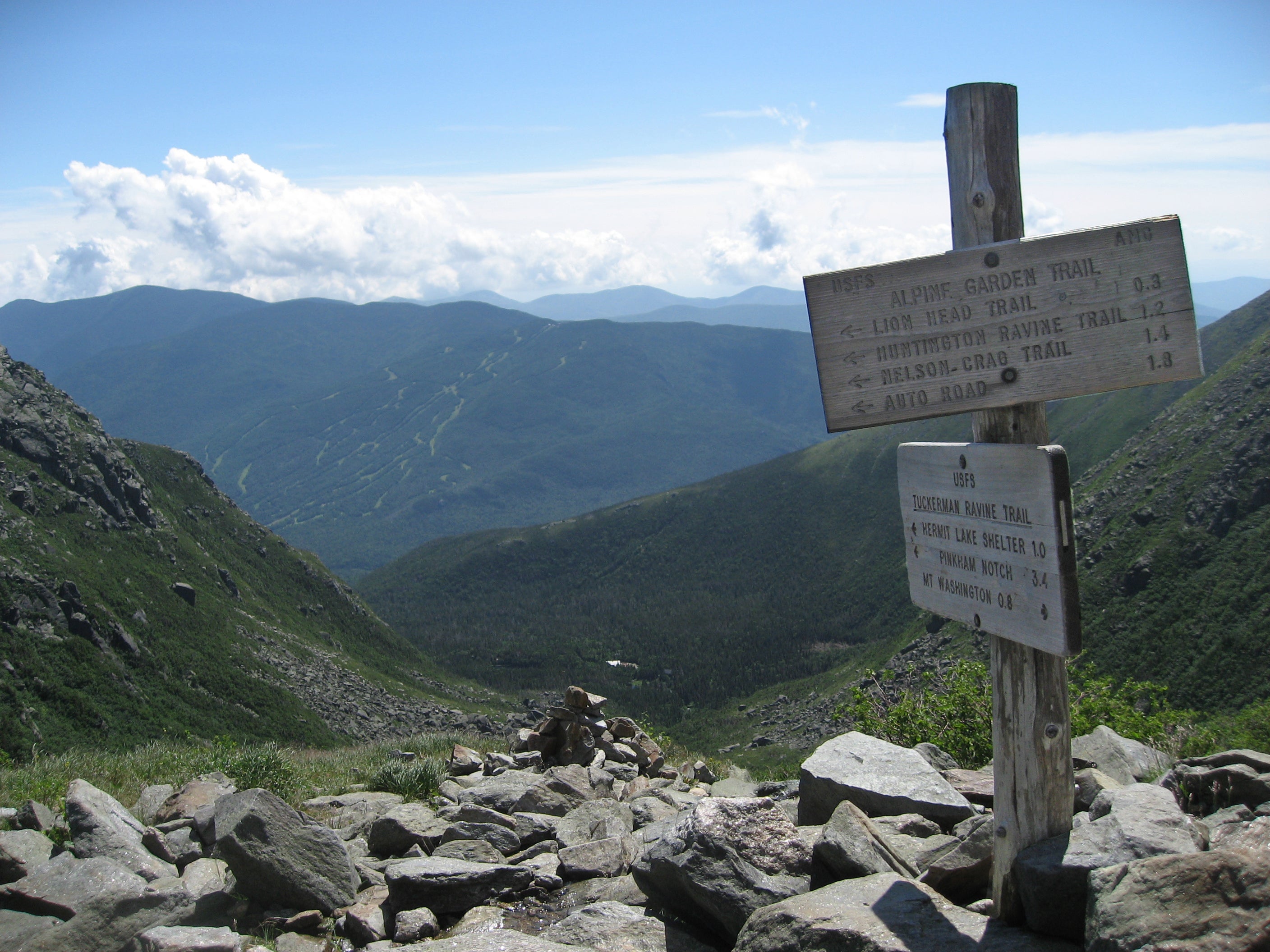
From here, the trail narrows and the climb becomes steeper. At mile 3.1, reach the floor of Tuckerman Ravine, surrounded by alpine ridges 1,500 feet above. Traverse the length of the ravine floor and arrive at the headwall, where another waterfall marks the gulch’s end. Up the headwall, the hike becomes a scramble. Keep an eye out for streams trickling down the rock wall, and take care not to send loose rocks tumbling onto hikers below. These steep slopes are covered in snow for more than half of the year, and are regularly closed during late spring, when ice thaws and the main waterfall begins to open. Summit the wall at the junction with the Alpine Garden Trail, 1,300 feet above Tuckerman Ravine
Alpine Garden Trail Junction to Summit Cone
Ignore the cairns ahead of you and turn right (north) to continue across the scree field another .6 miles and 1,000 vertical feet to the summit. Then, enjoy the view: On a clear day, you can gaze 130 miles away to New York, Quebec, and the Atlantic Ocean. Spot 4,000 and 5,000-foot White Mountains peaks: Mount Jefferson, Mount Adams, and Mount Madison to the north, Carter Dome to the east, and Mount Carrigan to southwest. The summit has restrooms, gift shops, a cafeteria, and a museum.
From here, you can retrace your steps for a 7.2-mile out-and-back, hitch a ride back to the trailhead, or get creative with a lollipop loop:
● To extend the challenge: Descend the rocky scramble down Lion Head Trail on the way back. Caution: It’s roughly the same distance, but much steeper and more difficult than the Tuckerman Ravine Trail.
● For bonus views from the ravine’s south ridge: Turn right onto the Boott Spur Link Trail at Hermit Lake, then left at the Boott Spur Trail. This detour will lengthen the trip by a quarter mile.
“The Worst Weather in America”
 Facing ominous weather on Mount Washington? Turn back.Rich Moffitt
Mount Washington is notorious for its extreme weather. In the winter, it can get frigid: In 2004, the summit weather station recorded a wind chill of -102 Fahrenheit. The winds on top are higher than anywhere else in the Western Hemisphere, with a record speed of 231 miles per hour. As the warning signs leading to the summit warn visitors: “The area ahead has the worst weather in America. Many have died there from exposure, even in the summer.” Bring a shell and insulation no matter how good the forecast is, and be prepared to turn around at the first sign of bad weather.