Where Solitude Rules - Surprise Escapes

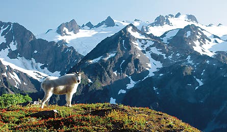
'Olympic National Park (Don Geyer)'

Olympic National Park (Don Geyer)

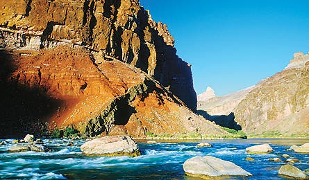
Grand Canyon (Dave Showalter)
Olympic National Park, Washington | Yosemite, California | Adirondacks, New York | Indian Peaks, Colorado | Grand Canyon, Arizona
Olympic National Park, Washington
Test your mountain skills on the Bailey Range’s haute route.
Olympic is the fourth busiest national park in America, but most visitors crowd onto beach walks and short trails. In the wild interior of the park rises the Bailey Range, a 65-mile semicircle of peaks looping around Mt. Olympus, the peninsula’s hulking, 7,980-foot summit. The challenging Bailey haute route traverses the range from north to south, beginning with a 12-mile hike along the Sol Duc River and High Divide Trails to Cat Peak, where the trail ends and an airy ridge called the Cat Walk begins.
From there, it’s about 30 miles and at least three days of ridge scrambling, snowfields, and cross-country navigation to reach the headwaters of the Elwha River and Low Divide, where you’ll rejoin maintained trails. The traverse requires rudimentary mountaineering skills–snow travel with an ice axe and crampons–plus simple rock scrambling and solid routefinding ability. (But you won’t need a rope.) Allow plenty of time for extracurricular exploration: While camping in high meaows, you can bag half a dozen summits along the way, including Mt. Carrie (6,995 feet), and you’ll want to linger over views from glaciers to the Strait of Juan de Fuca. Emerge on the Elwha River Trail or North Quinault Fork Trail to end.
Days 6-8
Map Trails Illustrated Map #216, Olympic NP ($12, natgeomaps.com)
Permits Wilderness permits ($5 per group, plus $2 per person per night) are required; early reservations are only recommended for the first night’s campsite below Cat Peak.
Infonps.gov/olym
Olympic National Park, Washington | Yosemite, California | Adirondacks, New York | Indian Peaks, Colorado | Grand Canyon, Arizona
Yosemite, California
Mt. Watkin’s trailless summit yields sweet views.
The granite walls of Mt. Watkins form one side of Tenaya Canyon, the eastward extension of Yosemite Valley. From the summit, you’ll see lines of hikers crawling like ants up Half Dome, but odds are you’ll be all alone on this trailless peak. Start at Olmstead Point, just off Tioga Road, and follow an unnamed trail west toward Snow Creek.
When the trail climbs over a ridge at 2.5 miles (UTM 11S 0278251E 4185983N, WGS 84), head cross-country and follow the ridge south and southwest to reach the peak after less than a mile. For the best views, continue down gentle slabs toward the lip of Watkin’s south face. From July to Labor Day, you can take the Tuolumne Meadows Hikers Bus (yosemitepark.com) from Yosemite Valley to Olmstead Point and climb Watkins midway through a 10.9-mile, mostly downhill hike to the valley.
Days 1
Map Trails Illustrated Map #206, Yosemite NP ($12, natgeomaps.com)
Permits None for dayhikes
Infonps.gov/yose
Olympic National Park, Washington | Yosemite, California | Adirondacks, New York | Indian Peaks, Colorado | Grand Canyon, Arizona
Adirondacks, New York
Scramble the Great Slide to the top of East Dix.
Few summits in the Dix Range have maintained trails, all but guaranteeing solitude in this quiet corner of the High Peaks. To climb 4,012-foot East Dix, you’ll follow unmarked social trails and the Great Slide, an exciting scramble on the northwest face. From NY 73, hike along two forks of the Bouquet River through a birch forest, reaching the Great Slide after 5.5 miles.
The swath of broken granite shoots up 850 feet at an average angle of almost 40 degrees. In dry conditions, it should be a cinch, but don’t let your guard down–you’ll definitely need to use your hands at the top. (Don’t like exposure? A social path weaves through the trees alongside.) From the summit, return the way you came or continue over South Dix, Hough Mountain, and Dix Mountain (stock up on water for this challenging three-mile traverse). At the summit of 4,857-foot Dix Mountain, you’ll finally reach a maintained trail, which you can follow about five miles north to the highway, ending 1.9 miles from your car.
Days 1
MapsUSGS topos Witherbee and Mt. Marcy
Permits None for dayhikes
Infoadk.org
Olympic National Park, Washington | Yosemite, California | Adirondacks, New York | Indian Peaks, Colorado | Grand Canyon, Arizona
Indian Peaks, Colorado
Bag a pair of 12,000-footers along this serene loop.
At the packed parking lots on the east side of the Indian Peaks, you’d be hard-pressed to say what’s so wild about this 76,711-acre wilderness. But the west side, one hour’s drive farther from the Denver-Boulder outdooropolis, is another story. For a weekend loop, start at Monarch Lake trailhead, east of Granby, and hike 8.2 miles to a campsite by rock-rimmed Gourd Lake.
The next day, climb to a saddle between 12,296-foot Cooper Peak and 12,041-foot Marten Peak for commanding views along the Continental Divide. Bag both summits, then continue down trailless scree to a camp near Stone Lake at the head of Hell Canyon, beneath Hiamovi Tower’s granite ramparts. In the morning, follow the Roaring Fork Trail through meadows and descend 6.6 miles to Lake Granby (1.5 miles from your car). Bonus: Spend an extra night at Stone Lake and climb 13,138-foot Ogalalla Peak.
Days 3
Maps USGS topos Isolation Peak, Monarch Lake, and Shadow Mountain
Permits Required ($5/group)
Info (970) 887-4100; fs.fed.us/r2/arnf
Olympic National Park, Washington | Yosemite, California | Adirondacks, New York | Indian Peaks, Colorado | Grand Canyon, Arizona
Grand Canyon, Arizona
Tackle a challenging 51-mile trek that reaches the remote Little Colorado River.
You’ll see more river runners than hikers on this unforgettable tour, thanks to two of the toughest rim-to-river trails in the Grand Canyon and a tricky route that connects them. Start with the nine-mile, 4,600-foot descent of the Tanner Trail, from AZ 64 near Desert View; the winding Colorado River comes into view about halfway in, pulling you downward.
At the river’s edge, continue north toward Marble Canyon along the Beamer Trail. From a beach camp by Palisade Creek, dayhike 6.6 miles to the Little Colorado River and its swim-worthy turquoise waters. Now psyche up for the two-day hike downstream along the Escalante Route, which climbs up to 1,000 feet above the Colorado, with tricky routefinding and scrambling by Seventyfive Mile and Papago Canyons. From roaring Hance Rapid, follow the New Hance Trail past the dunes of Red Canyon and up through the Redwall and Supai formations to the rim.
Days 5-6
Map Trails Illustrated Map #207, Grand Canyon NP ($12, natgeomaps.com)
Permits Overnight permits ($10, plus $5 per person per day) required
Infonps.gov/grca