Become a Member

Get access to more than 30 brands, premium video, exclusive content, events, mapping, and more.

Already have an account? Sign In

Become a Member

Get access to more than 30 brands, premium video, exclusive content, events, mapping, and more.

Already have an account? Sign In

Brands

Colorado Trails

Weminuche High Route

Try a stunning new hike in the Colorado Rockies' top spot for big backpacking adventures.

Heading out the door? Read this article on the new Outside+ app available now on iOS devices for members! Download the app.

This 50.5-mile hike runs south-to-north across Endlich Mesa, Silver Mesa, the Needle Mountains, the Grenadier Range, the Highland Mary Plateau, and Arrastra and Spencer Basins before plunging straight into downtown Silverton. Along the way, you’ll encounter spectacular plateaus of rolling tundra, ripsaw ridges, cliff-ringed lakes, and lush midsummer wildflowers, but it’s not a route for the lazy or unacclimatized. For most of its length, you’ll wander up and down through a succession of steep passes, with long stretches above 12,000 feet. Budget at least seven days; peakbagging and side hikes beg for more time. About half of the route requires off-trail routefinding. We recommend downloading the author’s track log and waypoints for map-plotting or GPS use. Despite often steep terrain, there’s no exposed scrambling that requires ropes—unless you go in spring, when an ice axe and/or crampons would also be useful for steep snow.

Maps: Trails Illustrated 140 Weminuche Wilderness, and USGS topos Columbine Pass, Storm King Peak, Howardsville, and Silverton
–Mapped by Steve Howe

None

Trail Facts

  • Distance: 81.3

Waypoints

WEM001

Location: 37.4772605895996, -107.631538391113

Endlich Mesa Trailhead Kiosk

WEM002

Location: 37.4909553527832, -107.610694885254

Weminuche Wilderness Boundary

WEM003

Location: 37.5189819335938, -107.602226257324

Pass begins descent to Lower Park

WEM004

Location: 37.5260276794434, -107.598281860352

Trail junction; stay left

WEM005

Location: 37.5348701477051, -107.608558654785

Trail junction; turn right/NE

WEM006

Location: 37.539737701416, -107.600387573242

Lake

WEM007

Location: 37.5449333190918, -107.592422485352

Trail junction; stay left

WEM008

Location: 37.5521697998047, -107.59268951416

Good watering site. Follow developing trail N. as it curves West up onto Silver Mesa

WEM009

Location: 37.5710792541504, -107.605400085449

Pittsburgh Mine. Beware of dangerous vertical shafts.

WEM010

Location: 37.5801544189453, -107.597633361816

Trimble Pass: Excellent views northward to main Needles group

WEM011

Location: 37.5971031188965, -107.59928894043

Columbine Lake

WEM012

Location: 37.6018257141113, -107.591941833496

Unnamed pass to Hazel Lake. Descent trail East is exposed; use caution.

WEM013

Location: 37.6047592163086, -107.588371276855

Hazel Lake; scenic campsite

WEM014

Location: 37.5918846130371, -107.593269348145

We rejoined Johnson Creek Trail. More efficient route is to descend directly from Columbine Lake.

WEM015

Location: 37.5889129638672, -107.534629821777

Ford Johnson Creek. Could be tough in spring.

WEM016

Location: 37.5842819213867, -107.531150817871

Pack bridge across Vallecito Creek

WEM017

Location: 37.6298332214356, -107.538513183594

Turn Left at small cairn. Follow sketchy trails NW across meadows.

WEM018

Location: 37.6311454772949, -107.53938293457

Ford Vallecito Creek. 100 feet across. Knee deep or deeper. Probably impossible in high run-off.

WEM019

Location: 37.6336059570312, -107.540245056152

Huge avalanche debris pile. Clamber over logs as needed for 1/4- to 1/2 -mile.

WEM020

Location: 37.6358451843262, -107.55249786377

Rejoin solid trail

WEM021

Location: 37.6335639953613, -107.56494140625

Jaw-dropping views enroute to Sunlight Lake

WEM022

Location: 37.6341552734375, -107.581108093262

Sunlight Lake

WEM023

Location: 37.6386947631836, -107.578788757324

Turn North off-trail. Climb steep tundra gullies to ridgeline pass.

WEM024

Location: 37.6461639404297, -107.578636169434

Unnamed pass into broad tundra basin

WEM025

Location: 37.6509170532227, -107.579551696777

Unnamed pass; may need ice axe for descent down snowfields to north

WEM026

Location: 37.6603927612305, -107.573539733887

Best route actually climbs straight north from tarn, crosses pass, and drops to basin South of Peak Seven.

WEM027

Location: 37.6624336242676, -107.567398071289

Sketchy scrambles across steep slab band. Best route is further west

WEM028

Location: 37.6655654907227, -107.568710327148

Unnamed pass

WEM029

Location: 37.6701240539551, -107.57006072998

Unnamed pass

WEM030

Location: 37.6713981628418, -107.570236206055

Critical descent gully from pass between Peaks Seven and Eight

WEM031

Location: 37.6731796264648, -107.561828613281

Unnamed Pass. Begin boulderfield descent toward, but not down to, Lake Silex.

WEM032

Location: 37.6930809020996, -107.569671630859

Pass begins descent to Elk Creek Valley

WEM033

Location: 37.7129669189453, -107.566337585449

Strike user trail. Avoid logpile tangles visible below. Persevere until striking Elk Creek.

WEM034

Location: 37.7173271179199, -107.563484191895

More user trail leads to Colorado Trail

WEM035

Location: 37.726619720459, -107.576721191406

Small bridge across side creek. Begin looking for game trails climbing north.

WEM036

Location: 37.7408180236816, -107.579498291016

Hidden hunter’s camp on small bench above and east of gully

WEM037

Location: 37.7447547912598, -107.577560424805

Strike user trail; turn ENE

WEM038

Location: 37.746166229248, -107.575538635254

Strike maintained trail; continue north

WEM039

Location: 37.7490730285644, -107.576522827148

Verde Lake: Good watering point

WEM040

Location: 37.7667541503906, -107.582481384277

Leave major track. Follow faint user trail around corner and across sidehill. Soon becomes XC travel. Follow natural “trench” traversing sidehill to NW.

WEM041

Location: 37.7702140808106, -107.593933105469

Unnamed pass reached after skittery, steep talus climb thru conglomerate cliff bands.

WEM042

Location: 37.7779083251953, -107.607849121094

Game trail

WEM043

Location: 37.7808303833008, -107.608276367188

Very high unnamed pass. Look for airy mountain goat trail traversing west across face of Point 13,409.

WEM044

Location: 37.7941856384277, -107.613861083984

Another spectacular pass

WEM045

Location: 37.7975997924805, -107.625175476074

Last pass. May involve rotten cliff scramble up and around mine tunnel entrance that blocks easy pass crossing. Watch those handholds.

WEM046

Location: 37.8053741455078, -107.627510070801

Faint trail avoids cliffband descending Blair Gulch

WEM047

Location: 37.8075370788574, -107.627876281738

Very loose, unpleasant talus descent down to valley floor

WEM048

Location: 37.8113098144531, -107.633102416992

Summer cabin under construction. Follow access roads down to road network.Turn left at first major crossroad.

WEM049

Location: 37.8077621459961, -107.642433166504

Actual road intersection. Note: Roads on this maps in this area are inaccurately shown.

WEM050

Location: 37.8115615844727, -107.663032531738

End of route

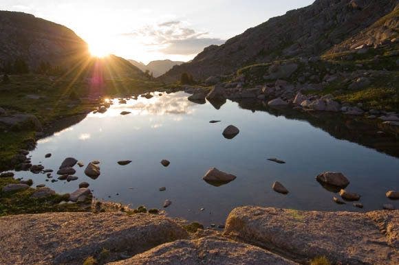
Sunlight Lake

Location: 37.6344261169434, -107.580657958984

Dawn does a doubletake on Sunlight Lake. © Steve Howe

How to Pack for Backcountry Skiing

Get to know the winter safety gear you need in your pack.

Keywords: