Hiking Vermont's Bourn Pond-Stratton Pond Loop: The Best Damn Weekend Ever

To call the 23-mile Bourn Pond-Stratton Pond loop hike through Vermont’s Lye Brook Wilderness inspirational barely gets at the truth. Sure, you can find taller peaks and less-traveled trails, but the stunning view from the loop’s high point–a fire tower atop 3,940-foot Mt. Stratton–is the spark that motivated the creation of both the Appalachian Trail and the Long Trail. The trail takes you through the heart of this 17,841-acre wilderness in Green Mountain National Forest near Manchester, Vermont. Most day hikers turn back at Prospect Rock, a popular perch you’ll pass en route to grander rewards. Plan to stay at shelters, and you can travel light, leaving your tent at home.
Trail Facts
- Distance: 23-mile loop
- Elevation: 4,200 feet
- Difficulty: Moderate
The Route: Bourn Pond-Stratton Pond Loop
The Bourn Pond-Stratton Loop hike takes you through lush hardwood forests, past multiple ponds and up majestic peaks with inspirational and stunning views along the whole trail.

Day One- Prospect Rock Trail to Douglas Shelter
Begin day one by climbing the steep and gravelly Old Rootville Road, also called Prospect Rock Trail, a mile east of Manchester. It’s an unrelenting 1,000 feet ascent in just 1.8 miles. Prospect Rock Trail ends at the spur to its namesake rock and the junction with the Appalachian Trail and Long Trail, which overlap for a 95-mile stretch. After enjoying the view of the verdant Otter Creek Valley and 3,816-foot Mt. Equinox—the tallest peak in the Taconic Range—continue south on the AT/LT.
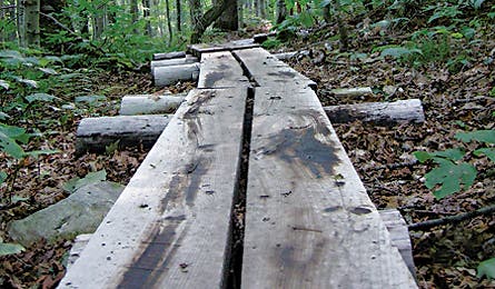
You’ll cross a tributary of sleepy Bourn Brook at 2.7 miles, then come to the junction with the Branch Pond Trail at the boundary of the Lye Brook Wilderness. This is the point where the loop begins and ends. The environmental change as you enter the designated wilderness area is immediate. First, you’ll cross several bog bridges, called “puncheons” by Long Trailers, as you pass through a lush hardwood cathedral. Colorful jewelweed blooms crowd against the foot-worn boards.
At 3.2 miles, you’ll reach Douglas Shelter, a classic eight-person lean-to nestled in a small clearing. Plan to spend your first night here.
Day Two: Douglas Shelter to Stratton Pond Shelter
From Douglas Shelter to Bourn Pond, it’s a rolling three miles through head-high goldenrod and prime moose habitat. With 5,000 of these large ungulates now roaming through Vermont’s woodlands, it’s hard to miss their scat and hand-size hoof prints. After a half-dozen stream crossings, you’ll come alongside Bourn Pond. Drop your pack and go for a swim in the cool water, and then let the resident loons provide lunchtime background music.
Air dry from your swim and continue east for 1.8 miles on Lye Brook Trail. Look for wild raspberries among the jumble of tree trunks as you pass through the remnants of a 2003 microburst. Stratton Pond lies over the next rise, just outside of the wilderness boundary. It’s the largest body of water on the Long Trail, more like a small lake than a pond. The hulk of 3,936-foot Stratton Mountain looms large across the water. Head to the south side of the pond and drop your pack at the three-bunk-high Stratton Pond Shelter.
From the pond, it’s a mellow 3.1-mile ascent on smooth trail through dense sugar maples to the top of Stratton Mountain. The fire tower on its summit is a national historic landmark, and is credited with inspiring two of the country’s landmark paths. Vermont’s Long Trail was conceived here in 1910 by James P. Taylor. Benton MacKaye’s AT vision followed in 1921. From 55 feet above the ground, the tower-top vista extends well into Massachusetts, Vermont, New Hampshire, and New York. Return to Stratton Pond for another swim or to cast a fly. State officials stock Stratton Pond with brook trout, which get little pressure due to the trek to get there.
Day Three: Stratton Pond Shelter to Prospect Rock Trail
On day three, take the AT/LT south, back into the Lye Brook Wilderness. From here, it’s a leisurely eight-mile finish as you meander through hardwoods and cross a footbridge over the Winhall River. Then close the loop near Prospect Rock and head downhill to the trailhead.
Parking & Logisitics
Directions and Parking
From Manchester Depot, go 0.6 miles toward Manchester on VT 11/30. Turn south on East Manchester Road, then bear left on Old Rootville Road (dirt). Drive 0.5 miles and park by the gate.
Permits and Camping
There are no permits needed for this hike and dispersed camping is allowed. If you stay at the Stratton Pond tent site there is a cost of $5.
Best Season for Hiking
The shelters are quiet in June and post-Labor Day. The Green Mountain Club discourages hiking here during mud season from snowmelt through Memorial Day.