Vancouver, WA: Klickitat Trail (Warwick to Swale Canyon)

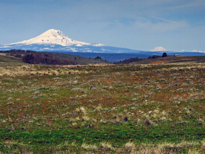
Connecting the small towns of Lyle and Warwick, the 31-mile Klickitat Trail traces an abandoned railroad corridor through scenic river canyons just north of the Columbia River Gorge. Sample a section of the picturesque trail on this 10.2-mile out-and-back that starts just west of Warwick and leads to a creekside lunch spot overlooking slickrock chutes and pools. From the trailhead on Centerville Road, hike west past the rolling hills and rangeland of Klickitat Valley; the glacier-covered slopes of Mount Adams rise in the distant northwest.
Near mile 2, the route starts its descent into Swale Canyon, a remote gorge punctuated with volcanic rock outcroppings and vibrant Columbia desert parsley. Cross three railroad trestles in the next one and a half miles and continue heading west. After 4.5 miles, the route swings to the north for the final 0.6 mile to a waterfront lunch spot along Swale Creek. Savor views of the creek’s chutes, waterfalls, and small pools before turning around and heading back to the trailhead.
Note: The Swale Canyon portion of the trail is closed when the Department of Natural Resource rates the fire danger in Klickitat County as “High”.
Info: Klickitat Trail Conservancy
-Mapped by Eli Boschetto, Bosco Mountain Photo


Trail Facts
- Distance: 16.4
Waypoints
KLK001
Location: 45.7206545, -121.0009262
From the trailhead on Centerville Road, hike west through Klickitat Valley. Rolling hillsides and rangeland extend into the distance; look to the northwest for views of Mount Adams’ glacier-covered slopes.
KLK002
Location: 45.7235682, -121.0308679
Cross Harms Road and continue hiking west. Note: Harms Road can be used as an alternate starting point for this hike.
KLK003
Location: 45.7232293, -121.0322249
Cross the first of three Spokane, Portland & Seattle railroad trestles.
KLK004
Location: 45.723682, -121.0412478
Pass through a cattle control gate; make sure to re-latch the gate. Ahead, the trail begins its descent into Swale Canyon. Note: There is no cell phone reception in the canyon.
KLK005
Location: 45.7214664, -121.0478043
Pass through another cattle control gate.
KLK006
Location: 45.7226169, -121.0547789
Cross a small trestle above a small inlet stream. The trail continues to meander through the canyon; look for volcanic outcrops and picturesque views of Swale Creek.
KLK007
Location: 45.7242129, -121.0634612
Walk across the longest of the three railroad trestles; the bridge curves to the northwest as it travels through a narrow section of Swale Canyon. After the bridge, keep an eye out for the brilliant pinks of Columbia desert parsley that grow along Swale Creek.
KLK008
Location: 45.7266297, -121.080966
Volcanic rock outcroppings border the trail on the right. In 0.3 mile, the trail rounds to the north and passes Stacker Canyon on the left.
KLK009
Location: 45.7291012, -121.0882187
Hike past a small, cascading waterfall that empties into Swale Creek.
KLK010
Location: 45.7328607, -121.0879076
Swale Creek flows over exposed bedrock, creating a series of chutes, sheet falls, and small pools. Drop your pack and grab a snack at this picture-perfect spot before turning around and heading back to the trailhead. Optional: For an all-day trip, continue hiking another 8.5 miles to the town of Wahkiacus.
Mountain Views
Location: 45.72272, -120.9967232
View of Mount Adams, Mount Rainier, and the Goat Rocks from Centerville Road near the trailhead. © Eli Boschetto
Starting Line
Location: 45.7206564, -121.000894
Trailhead entry gate on Centerville Road. © Eli Boschetto
RR Crossing
Location: 45.7232293, -121.0321176
Crossing the first of three trestles. © Eli Boschetto
Swale Creek
Location: 45.7224878, -121.0609567
A nice, shady rest stop along Swale Creek. © Eli Boschetto
Swale Canyon
Location: 45.7237985, -121.0618687
Spring color and exposed volcanic outcrops. © Eli Boschetto
RR Crossing
Location: 45.724218, -121.0631561
Third railroad trestle in Swale Creek Canyon. © Eli Boschetto
Canyon Color
Location: 45.7253864, -121.0704517
Columbia desert parsley along Swale Creek. © Eli Boschetto
Rainbow Rock
Location: 45.7266147, -121.08073
Large outcrop of colorful volcanic rock. © Eli Boschetto
Swale Creek
Location: 45.7318497, -121.0878432
Above the “bedrock pools” area. © Eli Boschetto
Bedrock Pools
Location: 45.7324338, -121.0877788
Pools along Swale Creek. © Eli Boschetto