Published June 24, 2010 07:37PM
Secret Hikes: Zion National Park
Pack an extra memory card for what is, mile-for-mile, the most photogenic hike in the Southwest.
'Zion (Joe Braun)'
| Secret Hikes: National Parks Home |
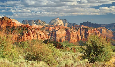
One of our most veteran trail scouts, who has hiked in 24 national parks and is notoriously grudging with superlatives, calls this 47-mile traverse of Zion “one of the most spectacular multiday treks in the entire park system.” The only debate: why so few people know about it.
The route, traversing the park north to south from Lee Pass to East Rim trailheads, includes a few popular dayhiker sections, but mostly it’s simply lonely, remote, and photo-every-step gorgeous. Start by crossing the orange and red Kolob Canyons and Hop Valley on the La Verkin Creek and Hop Valley Trails; camp beside burbling La Verkin Creek in Kolob (sites 12 or 13, at mile 6.7, have abundant flat spots above the creek). Then use the Connector and Wildcat Canyon Trails to link to the West Rim Trail. You’ll pass through the park’s highest elevations (above 7,000 feet) and an area called Little Siberia that’s snow-covered from November to May. Plan to linger at overlooks of labyrinthine side canyons of white and red sandstone. Overnight at campsites eight (mile five, near water) or four (mile 6.5, good views). From here, descend giant waves of sandstone along sidewalk-wide precipices with hundred-foot drops into Zion Canyon. Detour .8 mile round-trip to Angel’s Landing—get there before 9 a.m. to beat the hundreds of dayhikers who crowd the knife-edge footpath from mid-morning to late afternoon. Even if you’re late, it’s worth jostling elbows for the view of the entire Zion Canyon dropping 1,500 feet below the 5,790-foot summit.
ADVERTISEMENT
Continue to Echo Canyon and finish the traverse with a climb through bizarrely sculpted redrock—at the brink of a waterfall plunging into a slot canyon at Jolly Gulch—on the East Rim Trail. Drop your pack for the popular but worthwhile one-mile side trip along crazy-exposed paths to Hidden Canyon, with sweeping panoramas from atop the vertical walls. Water beta: La Verkin Creek runs year-round, and Beatty, Sawmill, and Cabin springs are usually reliable, but Stave Spring, near the East Rim’s campsites, typically dries up by August.
›› Magic Moment You wake early to watch pink and gold dawn light creep up a maze of side canyons and mesas, just five minutes’ walk north of the West Rim Trail’s campsite four.
›› Local Knowledge The slickrock between Angel’s Landing and the West Rim is a favorite spot for local guides to scramble off trail on formations that look like beehives.
›› Do it Begin at Lee Pass trailhead, about eight miles up Kolob Canyon Road from exit 40 on I-15. Finish at the East Rim trailhead on UT 9. Shuttle services: zionadventures.com; zionrockguides.com. Note: The park’s free buses don’t connect this route’s trailheads. Map Trails Illustrated Zion #214 ($12; natgeomaps.com) Contact (435) 772-0170; nps.gov/zion