Heading out the door? Read this article on the new Outside+ app available now on iOS devices for members! Download the app.
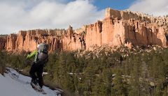
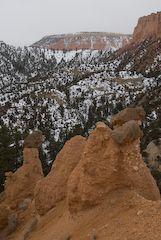
This three-day, 22.1-mile trek drops 1,000 feet from Bryce’s overlooks into spire-filled basins, then arrows south away from the crowded dayhike loops to 9,115-foot Rainbow Point, the park’s highest spot. From Bryce Point trailhead, keep right, following signs for the Under-the-Rim Trail. You’ll hike southeast across a timbered bench, then drop steeply to the Hat Shop, a series of improbable brown boulders perched atop dirt pedestals at mile 1.9.
Pass through the first campsite at Yellow Creek’s right fork and curve north along Yellow Creek, one of two reliable water sources on the trek. You’ll reach Yellow Creek Campsite at mile four, a great camp for night one. It’s creekside; top up water here before taking off because the trail is bone dry for the next 12 miles. From camp, the path climbs south, then veers west on a traverse to Pasture Wash, then up and over a series of steep passes to the Sheep Creek Campsite and the Right Fork of Swamp Canyon Campsite.
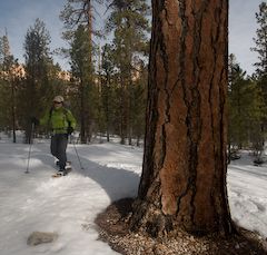
Keep trekking 1.7 miles up Swamp Canyon, wrapping around Swamp Canyon Butte onto a tilted plateau where you’ll pass a junction with .9-mile Whiteman Connecting Trail. At mile 14, you’ll come to a sandy ridgeline that’s an excellent lunch spot with reliable breezes and long views. Pass ponderosa stands and the Natural Bridge Campsite (sidehike west to see the bridge) before taking another twisty climb to a junction with Agua Canyon Connecting Trail.
Ahead, spot the intricate traverses you’ll follow around the headwaters of Willis and Black Birch Creeks over the next 2.4 miles to Iron Spring Campsite. Iron Spring is the last reliable water source. The next morning, drop down to Black Birch Creek—before a 1,200-foot, 2.9-mile climb to the end at Rainbow Point.
Permit: Park entry is $20/vehicle. Backcountry overnight permits are $5/one- to two-person party.
Gear up: Ruby’s Inn General Store has fuel, food, first-aid supplies, and basic hiking gear. 1000 South UT 63, Bryce Canyon City; (866) 866-6616
-Mapped by Steve Howe
Trail Facts
- Distance: 35.7
Waypoints
UTR001
Location: 37.603362, -112.156041
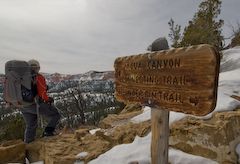
Trailhead sign
UTR002
Location: 37.592314, -112.144874
Trail rough from rim to here
UTR003
Location: 37.590868, -112.143738
Great views of Hat Shop, a series of improbable brown boulders
UTR004
Location: 37.587706, -112.147662
Nice campsite on the Right Fork of Yellow Creek; reliable water
UTR005
Location: 37.575554, -112.147134
Yellow Creek Group Campsite
UTR006
Location: 37.584744, -112.1623
Another campsite on Yellow Creek
UTR007
Location: 37.585583, -112.163455
Nice side strolls north and northwest to Yellow Spring and dramatic cliffs beneath Paria View.
UTR008
Location: 37.577856, -112.186634
Needle-floored Ponderosa Glades in Pasture Wash
UTR009
Location: 37.580333, -112.1961
Great break spot at ridgetop, with good views and breezes
UTR010
Location: 37.578828, -112.201777
Sheep Creek Campsite
UTR011
Location: 37.579418, -112.202422
Junction with Sheep Creek Connecting Trail Junction, heads north to park road, south to Tropic
UTR012
Location: 37.576811, -112.212761
Right Fork Swamp Canyon Campsite
UTR013
Location: 37.577577, -112.213172
Swamp Canyon Connecting Trail, runs north to rim and park road
UTR014
Location: 37.561144, -112.230067
Whiteman Connecting Trail. It’s 0.9 mile to rim and road
UTR015
Location: 37.526676, -112.24117
Natural Bridge Campsite. Good walking through ponderosa groves in the area.
UTR016
Location: 37.51443, -112.248256
Agua Canyon Connecting Trail. 1.6 miles to rim and road. Not recommended in winter, when switchbacks are filled in, and terrain is avalanche-steep.
UTR017
Location: 37.4917878, -112.2441374
Iron Spring: Water is often algae-filled. Try pre-filtering it through a standard conical coffee drip.
UTR018
Location: 37.4873091, -112.226827
Nice lunch spot on saddle
UTR019
Location: 37.4752808, -112.2402237
Rainbow Point: Trip’s endpoint
POI001
Location: 37.595578, -112.208541
Sheep Creek Trailhead
POI002
Location: 37.587672, -112.213131
Swamp Canyon
POI003
Location: 37.564186, -112.238922
Whiteman Trailhead
POI004
Location: 37.503805, -112.262739
Agua Canyon Trailhead
Sidehill traverse
Location: 37.5798206, -112.194314
The Hat Shop
Location: 37.5910093, -112.143631
Ponderosa forests in Yellow Creek
Location: 37.5834597, -112.1606255
Agua Canyon Trail
Location: 37.5144236, -112.2481728
Steep climb near trip’s end
Location: 37.4885483, -112.2259426