Published September 24, 2025 06:14PM
Washington's Goat Lake Trail Is a Gorgeous Hike With a Forgotten History
Nestled in the heart of the North Cascades, the Goat Lake Trail is a perfect dayhike to see waterfalls, dense old-growth trees, and some snippets of an old mining settlement.
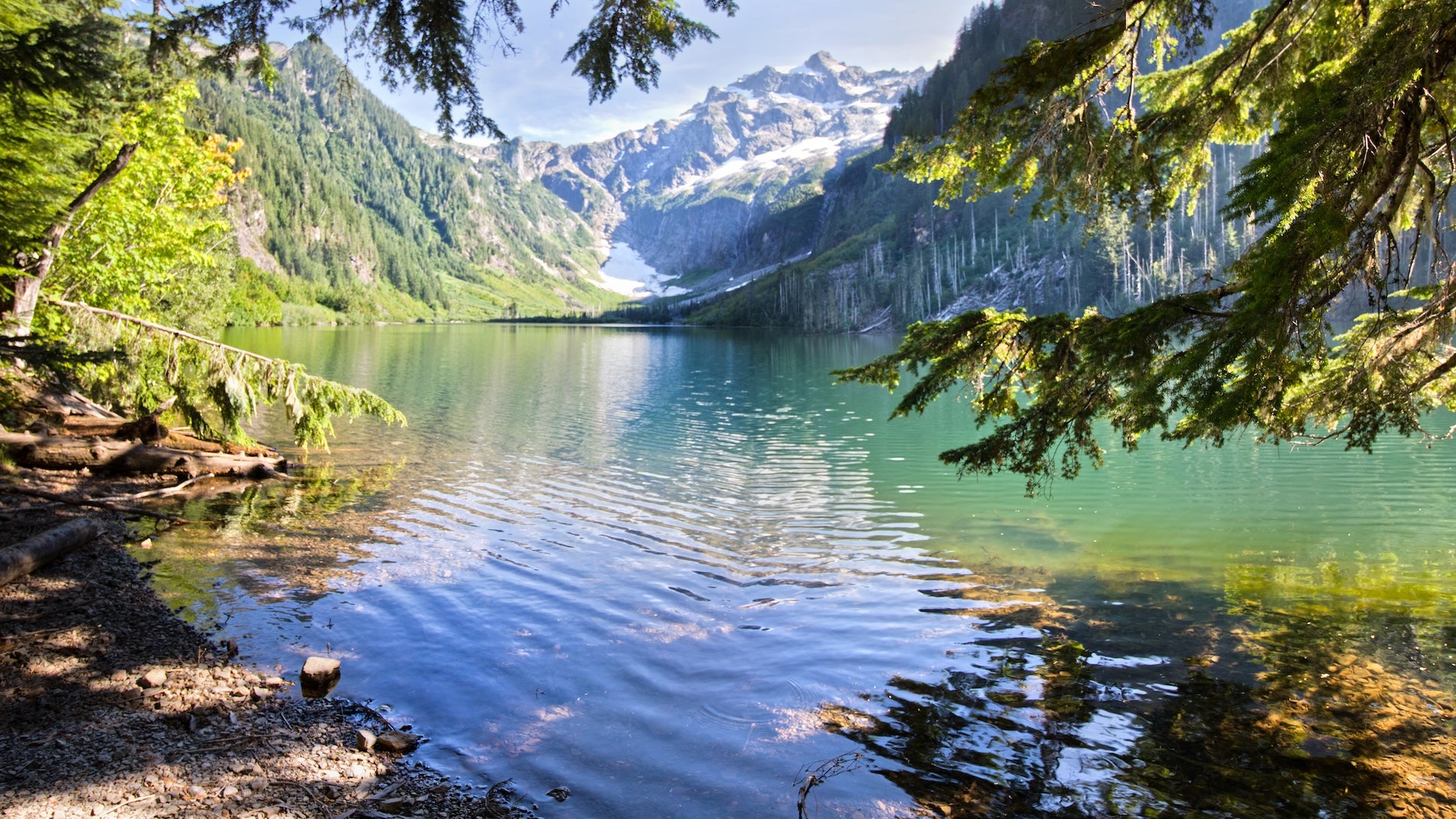
(Photo: Valentina Gatewood via Getty Images)
Goat Lake Trail, northwest of Seattle, seemingly has everything. One highlight is Mackintosh Falls, a fast-paced, downward hopscotch, one whitewater cascade after another, falling 200 vertical feet. Also, this hike is a two-fer: Shortly after the trailhead, the path forks and turns into the Upper Elliott Trail and the Lower Elliott Trail, both of which beckon to Goat Lake. Take one up and the other down, transforming a lollipop loop into a trail with different terrain almost the whole way. Both routes rejoin before Mackintosh Falls, a prelude to the cirque-walled, glacier-fed waters of Goat Lake.
Basic Facts:
Length: 10.2 miles
Elevation Gain: 1,910 feet
Similar Reads


Access: Less than a two-hour drive northeast of Seattle; family- and dog-friendly, but dogs should be leashed. Trailhead parking on summer weekends is at a premium. Arrive early. On one July Saturday this year, all the spaces were taken both in the parking lot and on the road, cars lined up, idling and waiting.
Permits: Agency pass required to park (See Northwest Forest Pass link for options). There is no internet at trailhead, arrange the parking pass beforehand.
Camping: Fifteen sites at Goat Lake. No permit required. Self-register at trailhead. Camp at least 200 feet from lake. No campfires allowed.
Toilets: The trailhead has a vault toilet outhouse. Opinions vary from “GREAT” to “stinky.” Bring your own TP. The campsites have two box-style, open-air toilets. Heavily used; so it’s doubly important to carry out your TP.
Goat Lake Trail
Goat Lake sits cupped in an amphitheater of snow-necklace peaks. Cadet Peak (7,186 feet) dominates the view to the south, towering four thousand feet above Goat Lake. Just before that first breathtaking view, 15 campsites lie to the left of the trail on a terraced hillside above a signed junction. Two box-style privies are further uphill. The signed day-use area farther on overlooks the water, making a great spot for lunch, frigid swimming, or shooting magazine-cover-worthy pics. Even on crowded weekends, there’s room to spread out.
Two Routes:
As previously mentioned, soon after the trailhead, a well-signed junction presents a choice. You can choose to do both as a loop, or pick one as an out-and-back. Here are the highlights of both.
Lower Elliott: At the fork, turn right to take Lower Elliott Trail. This route twists through the dense underbrush near Elliott Creek, often blanketed by a thick canopy of old growth. The creek teases, gurgling loudly as it pops in and out of view. One wouldn’t be surprised to spy Tolkien’s Rivendell around the next bend. Hikers are so enamored with Lower Elliott that many take it both up and back.
Upper Elliott: At the fork, turn left and north to take the mile-longer Upper Elliott. This route follows an old mining road, wider and less brushy than its streamside counterpart. The route is exposed to the sun, but the tradeoffs are views of the Elliott Creek valley and the surrounding Monte Cristo Peaks. Hiker opinions vary from “both upper and lower trails are beautiful” to dishing on Upper Elliott as “desolate and less scenic,” or even “boring.”
Chocwich Side Trail: Upper Elliott has one leg up on the lower trail. Within a mile, it leads to a side trail to Chocwich Falls. Just before Upper Elliott makes a hard U-turn, there’s a junction with the Chocwich Falls trail continuing north, while Upper Elliott veers right. Stay alert and don’t take Chocwich by accident. From the junction, the falls are a mile and a 400-foot gain ahead. For a shorter hike, one with solitude, consider a Chocwich Falls out-and-back.
What Kind Of Wildlife Is Along The Goat Lake Trail?
What about the goats, the lake’s eponymous namesakes? Sorry to say, don’t expect any. Dozens of trail reports were posted by this year’s hikers, but not one mentions a single sighting. Do expect snakes, marmots, bull frogs, perhaps a wayward bear cub, and expect oft spoken, but never sighted, rumors of cougars.
That rat-a-tat-tat from a nearby conifer might be North America’s largest woodpecker. Up to a foot-and-a-half long from head to tail, the Pileated Woodpecker was the inspiration for Woody Woodpecker. In the lake itself, fish with a baited hook, cast a fly or spinner, and land planted rainbow trout or one of a self-sustaining population of brook trout.
What’s The History Of The Goat Lake Trail?
The scenery, lake and wildlife justify Goat Lake’s popularity, but half the story is missing. Would Spain’s Camino de Santiago be famous if no one knew its religious origin? Alaska’s Chilkoot Trail might be a map footnote except that it’s path of the Klondike Goldrush. Goats are not the only thing missing at Goat Lake. Most every report on the lake ignores its history.
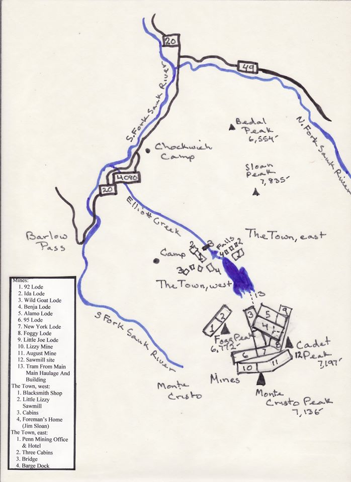
Today, Goat Lake is a ghost town. Around the turn of the 20th century, the Penn Mining Company built a thriving mine settlement here, a three-story office and hotel, a sawmill, blacksmith shop, homes, and cabins. A dozen named mines penetrated the slopes high above. Mining camps were strung halfway up the side of Cadet Peak. The largest buildings survived into the 1960s, when the Forest Service razed them.
Look at the map below and imagine. Mackintosh Falls is named for Willam and Charles Mackintosh who ran the Penn Mining Company operation. Elliott Creek is named for early prospector Thomas R. Elliott. The campsites mark the spot of the Penn Mining Co. Hotel and Office. For years, hikers spotted the occasional milled timber. With binoculars, it’s still possible to find Mine No. 3 Wild Toad Lode.
How Do You Get To The Goat Lake Trail?
First make sure you have the right Goat Lake. There are two others in Washington State. Here’s the right one. From Granite Falls, Washington, follow the Mountain Loop Highway east for 31 miles to Barlow Pass, where the pavement ends. Continue for 3.5 miles on the unpaved route to Forest Road 4080 (sign for Goat Lake Trail). Take Forest Road 4080 ¾ mile to its end at the trailhead. Granite Falls is about an hour from both from Seattle and Bellingham.