Heading out the door? Read this article on the new Outside+ app available now on iOS devices for members! Download the app.
Whether or not you believe in energy vortices, you’ll feel something special the minute you step foot on the Devil’s Bridge Trail hike. From multi-day trips to easy-access dayhikes, the trails around Sedona run the gamut from beginner to difficult. Devil’s Bridge is one of the most popular for a reason. At 4.2 miles, the hike to Devil’s Bridge is short enough for new hikers and families, but the views, the desert, and the arch itself will even have experienced hikers marveling at it all. Here’s everything you need to know before you head out on the trail.
Trail Facts
- Distance: 4 miles out and back
- Elevation Gain: 520 feet
- Difficulty: Easy to Moderate
The Route

Where to Start
There are two trailheads for Devil’s Bridge. Your start point will be dependent on what vehicle you’re taking there. For hikers who have a 4×4 with good clearance, starting at the Devil’s Bridge Trailhead cuts two miles off of the total distance. Head up Dry Creek Road to the trailhead, then start up the path.
If you don’t have 4×4 capability, you can park at the end of the short paved section of Dry Creek Road and continue up the 4×4 track. Walking up Dry Creek Road tends to be dusty, very exposed to the sun, and has little in the way of views. For a much better experience, head to Mescal Trailhead, off Long Canyon Road. From here, take the more scenic Mescal/Chuckwagon Trail to the Devil’s Bridge Trailhead.
Mescal Trailhead to Devil’s Bridge
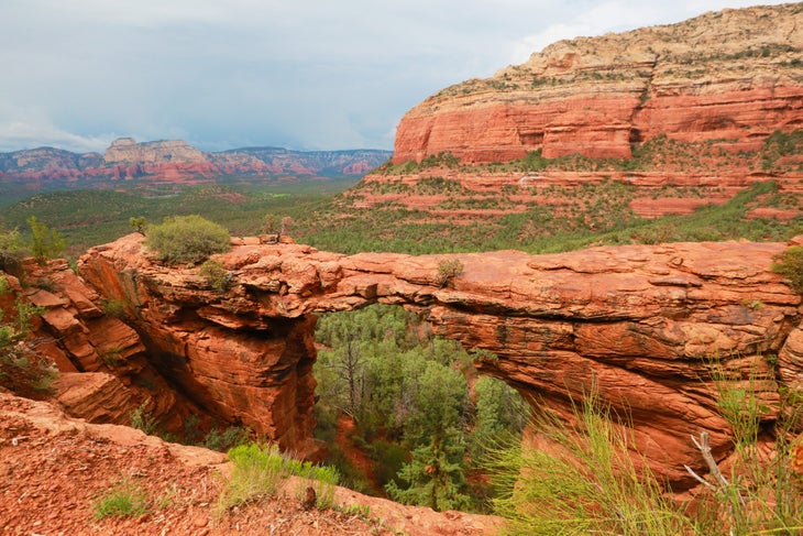
From the Mescal Trailhead, head onto scenic singletrack through the desert. Red sand, juniper, and pine spread out to all sides. A mile in, cross Dry Creek Road to the Devils Bridge Trailhead. Weaving through patches of juniper and pine forest, the Devil’s Bridge Trail spends a lot of time in the open, where the red rock mountains that characterize the Sedona area are visible in the distance. The darker red-orange stripes at the bottom and paler upper sections represent different geologic periods, when different kinds of sediment were formed by the advance and retreat of a shallow sea. These mountains are actually eroded pieces of the Mogollon Rim, which splits the Colorado Plateau and Basin and Range.
After starting as a wide former access road, the trail narrows. Look closely at the mountain rising in front of you and you’ll spot an enormous boulder balanced precariously over the cliffs. Just before reaching the bridge, a series of rock steps and occasional scrambles make up the hike’s remaining elevation gain.
A flat area beside the arch is the perfect place to take in the bridge itself and the mountains beyond. Adventurous hikers can walk out onto the bridge itself for a unique photo op. The arch is about 5 feet wide where you can walk along the top, 54 feet tall, and 45 feet long.
Best Time to Hike Devil’s Bridge Trail
This route is one of the most popular hikes in Sedona (for good reason). Start early or late to avoid the crowds and heat, and to ensure you get parking. The Dry Creek parking lot can fill up very quickly, especially on weekends, and the Mescal Trail trailhead doesn’t have many spots available.
In the popular spring and fall hiking seasons, there are so many hikers you might have to wait an hour just to walk on Devil’s Bridge. Early-morning starts let you leave before the crowds arrive. Alternately, start later, when most hikers have already headed back to town for dinner. You can catch the sunset before hiking out by headlamp.
Though the steeper sections of trail can be icy in the winter (as can the bridge itself), the desert dusted in snow is an impressive site. With the right gear, a winter hike here can be excellent. Summer is often too hot for most hikers, and afternoon thunderstorms are more likely. If you keep an eye on the forecast, summer can offer good hiking opportunities, too.
Gear for Hiking Devil’s Bridge Trail
Make sure to bring plenty of water and sunscreen on this desert trail, especially on hot days. Sturdy, breathable hiking boots will keep pebbles and sand out of your shoes while preventing sweat from building up. They’ll tackle the scrambly sections of trail without a problem. Throw in a rain shell in case of inclement weather, and as always, make sure you have the 10 essentials.
Permits for Hiking Devil’s Bridge Trail
A Red Rock Pass is required for this trail ($5 a day or $15 per week). They can be purchased online at recreation.gov or in-person at the Red Rock Ranger District Visitor Center or several of the supermarkets and hotels in Sedona. If you have an America the Beautiful pass, you can use that instead.
The Map: Devil’s Bridge Trail Hike
Other Nearby Trails to Check Out
- Brins Mesa Trail: 6.4 miles, panoramic desert views the whole way
- Soldier Pass Trail: 4.8 miles, straight from town to the mesa top
- Oak Creek: 6.6 miles, iconic sandstone cliffs beside a bubbling creek
- Courthouse Butte: 1.4 miles, epic views of sandstone towers
