Updated March 11, 2025 08:13PM
Have the Best Night of Your Life at These 10 National Park Campsites
The national parks are our national treasure, and these 10 campsites are the best they have to offer. Hike in, pick up your jaw, and post up in paradise.
(Photo: Michael Matti)
Far from being just a place to lay your head once you’ve done your mileage for the day, these 10 national park campsites promise epic views, solitude, and an immersive outdoor experience that will leave you feeling like you’ve truly gotten away from it all. Tip: Click on the coordinates at the end of each entry to find the trailhead on Gaia GPS. —The Editors
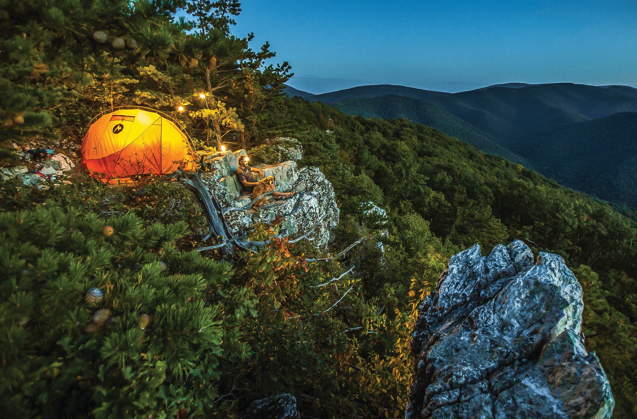
Off the Beaten Path: Rocky Mount, Shenandoah National Park, Virginia
Welcome to the insider’s club. As soon as you leave behind Skyline Drive and the Appalachian Trail, you’ll enter a corner of Shenandoah all your own. The handful of hikers who venture up 2,741-foot Rocky Mount tend to do the 10-miler as a dayhike, but not you. Tucked atop a granitoid outcropping you’ll find a solitary, secret campsite and views over Rocky Mount and the Southern Shenandoah Wilderness. Pitch your tent as close to the edge as you dare (there’s only one obvious spot, but don’t worry—it’s seldom occupied. When in doubt, there are more sites past the summit about a mile down the Gap Run Trail). Find the perfect backrest on a lichen-covered ledge and settle in to watch sunset over the Blue Ridge. Get here from the trailhead just north of the Two Mile Run overlook on Skyline Drive. Follow a ridge through oak-hickory forest for 2 miles with intermittent views before dipping down to a junction. A left turn will lead you 800 feet to the summit. Previously, downed trees and overgrowth encouraged hikers to catch these views from the road. But the trail has since been cleared, affording you smooth sailing and solitude worth staying the night.
Trailhead 38.2992, -78.6466 Get Here Park overnight at the Two Mile Run overlook at mile 76.2 on Skyline Drive. Permit Required; purchase on Recreation.gov
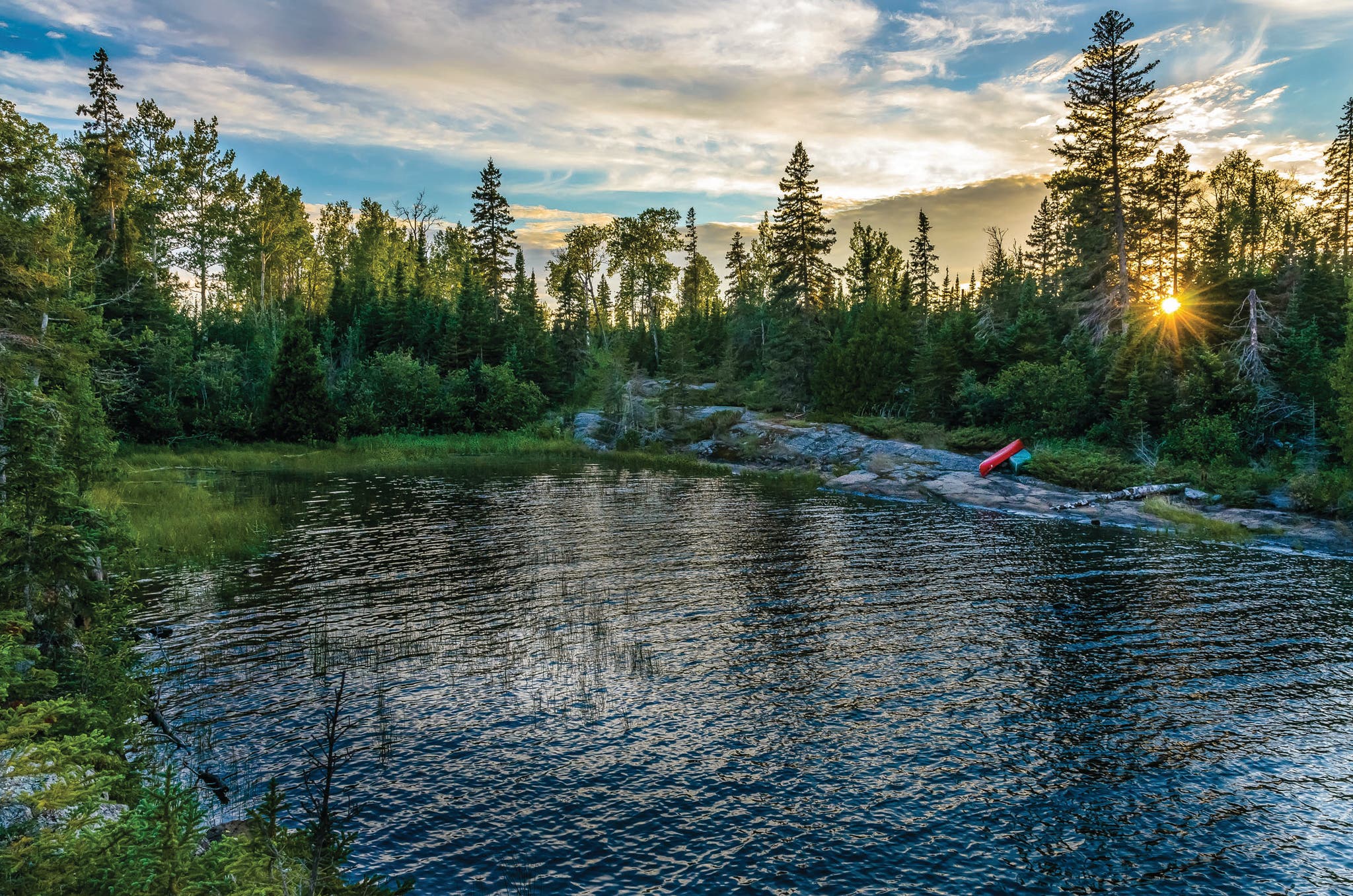
Private Island: Moskey Basin, Isle Royale National Park, Michigan
It starts with a halo of dawn light reflecting off the water. A loon’s resonant lilt breaks the silence. Beneath the awning of a wooden lean-to, watch the rising sun color the aspens, paper birch, and mountain ash surrounding the long inlet. Before long, the 3-mile stretch of water between Moskey Basin and the Rock Harbor Lighthouse will be bathed in soft pink. Swans drift by and river otters dive for trout and whitefish near the end of the natural rock ramp extending down from your campsite as the wilds wake up. Keep your ears open and your eyes up as you pack in the morning and you may be rewarded with the distant howling of wolves or a final flicker of green from last night’s aurora borealis. Reach this piece of paradise from the dock at Rock Harbor by hiking southwest on the Tobin Trail for 3 miles, then taking a left on the Mt. Franklin Trail. After a half mile, turn right onto the Rock Harbor Trail and continue on for 4.2 miles. At the next two intersections, take a right, and then a left, reaching Moskey Basin in another 3.9 miles. Alternately, experienced boaters who can read currents and manage wind-built swell (calmest early in the morning) can paddle the 3 miles from Rock Harbor. However you land, plan to turn in as the evening settles—you’ll want to be well-rested for one of the best wake-up calls in the entire national park system.
Trailhead 48.1444, -88.4855; Get Here $160, take the ferry from Cooper Harbor to the dock at Rock Harbor Permit Required, purchase on Pay.gov; six shelter sites are first-come, first-serve
ADVERTISEMENT
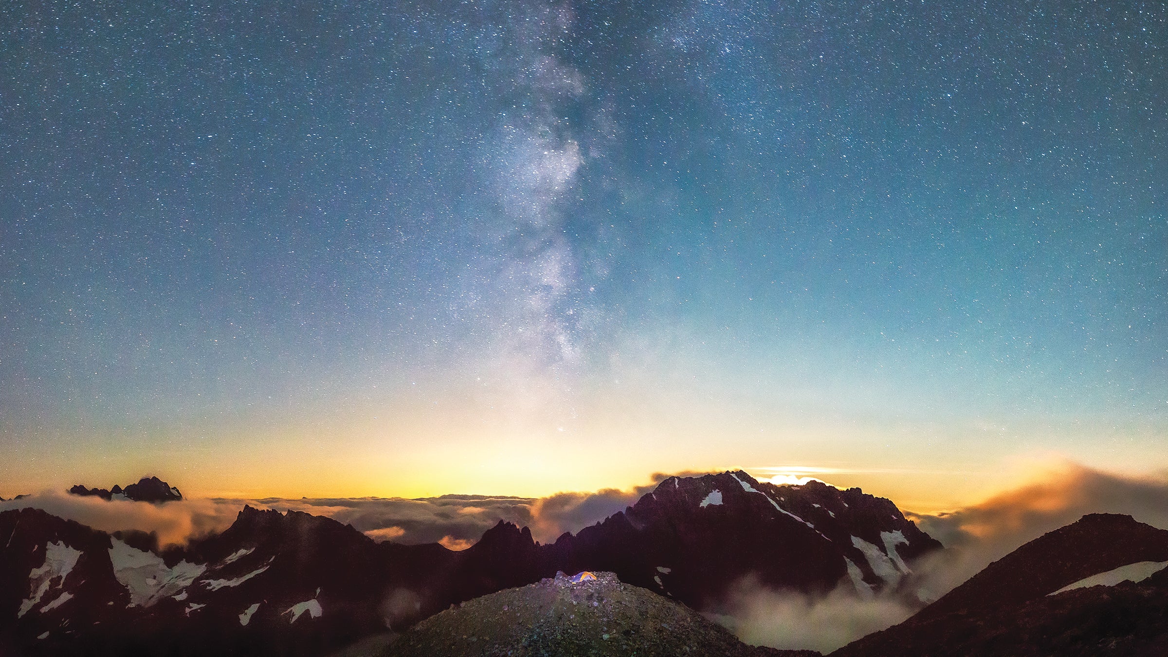
Stairway to Heaven: Sahale Glacier Camp, North Cascades National Park, Washington
It’s hard to say which sight is more awe-inducing: the North Cascades’ night skies or its peaks. Experience unobstructed views of both from the foot of the Sahale Glacier—at 7,400 feet, this is the highest campsite on our list. With a near 360-degree panorama of jagged mountains and hanging glaciers, you’ll have up-close encounters with Magic Mountain, The Triplets, and Mix-up Peak as 10,781-foot Baker and 9,131-foot Shuksan beckon in the distance. Of course, views like these come at the price of total exposure to the wind as it whips over rock and ice. That’s where the circular rock wall at your campsite comes in, providing just enough protection to keep you on terra firma. Start your climb from the Cascade Pass trailhead by hiking up 35 switchbacks over 1,700 feet until you break through the treeline. Traverse across a meadow brimming with wildflowers (and marmots) until you hit the intersection with the Sahale Arm Trail at mile 3.7. Swing a left and circle a thousand feet above the jagged shoreline of Doubtful Lake for another 2 miles. Listen for the telltale squeak of pikas as you scramble up the final 500 vertical feet to camp, and keep an eye out for the resident mountain goats while setting up your tent. Then, as the sun sets behind Forbidden Peak, lean back in your chair to watch the stars overhead emerge from the darkness. Enjoy the show.
Trailhead 48.4755, -121.0751 Get Here From Highway 20, drive south on the Cascade River Road for 23 miles to the trailhead Permit By lottery; enter on Recreation.gov or search for available dates for last-minute permits
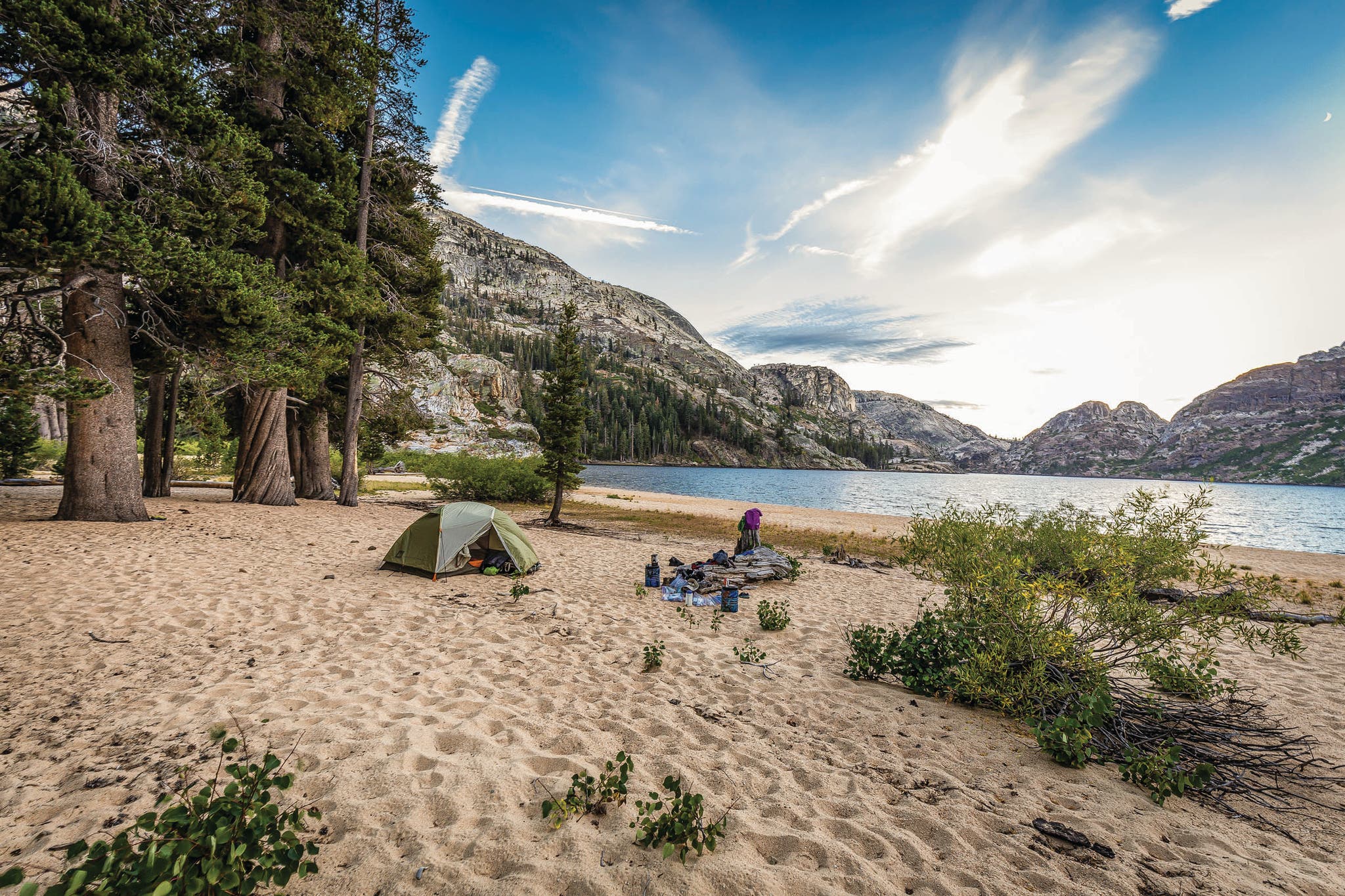
Beach Party: Benson Lake, Yosemite National Park, California
Trade the crowds squeezed between the Valley’s 3,000-foot granite walls for over 1,500 feet of white sand set against mile-long Benson Lake in the park’s remote northern backcountry. Make camp beneath a lodgepole pine—a prime source of shade—before wading out into the turquoise-blue water: Unlike other lakes in the area, this one, lower than most at 7,600 feet, is more than warm enough for a midday swim. When you’re finished, stretch out and catch some afternoon rays on the Riviera of the Sierra. Feel the gentle breeze roll across the lake as it rustles through the aspens and keeps the heat of the day (and the mosquitoes) at bay. Later in the afternoon, join the pelicans fishing for brook and rainbow trout at the lake’s outlet along Piute Creek—watch for river otters playing beneath the willow trees. Cap it off with a campfire (restrictions permitting) as the sun disappears behind the granite domes surrounding the lake, including 10,541-foot Piute Mountain to the northwest. To get here, follow the Robinson Creek Trail for 5.9 miles to connect with the Peeler Lake Trail. In another 1.9 miles swing left on the Kerrick Creek Trail and continue until you hit the PCT at mile 14.6. Follow that south for 3.6 miles, then take the Benson Lake turnoff. Reach the lake in another .3 mile. Camp here or walk as far along the beach as you like—finally, a place in Yosemite where there’s no competition for that perfect spot.
Trailhead 38.1464, -119.3800 Get Here Robinson Creek Trailhead is at the end of Twin Lakes Road; $5 overnight fee Permit By lottery on Recreation.gov, or snap up unused permits
ADVERTISEMENT
Before Sunrise: Campsite 5, Zion National Park, Utah
Never before have you faced such a dilemma as the one posed by Campsite 5 on the West Rim Trail. Do you set up your tent facing west, looking out across Phantom Valley to see evening light hit the white sandstone of piñon-topped Incline Temple and Church Mesa? Or do you orient yourself to the east for a show that begins at sunrise, as oranges and pinks reflect off the rock in Zion Canyon? The indecisive never had it so good. Whichever direction you choose, leave the fly off your tent (summer and fall are your best bets for clear skies) to watch as the Milky Way and stars wreath you on all sides. Your trek starts from the trailhead near Lava Point Lookout. Begin with a gentle downward descent from 7,800 feet along a shady plateau. Hit Potato Hollow Spring at mile 5.2 (check with rangers in the backcountry office to see if it’s running; pack in water if it isn’t). Veer right in 1.6 miles at the intersection with Telephone Canyon Junction. Hike another mile to reach the site—then drop your pack and check out the view from all angles before setting up camp. No wrong choices here.
Trailhead 37.3815, -113.0230; Get Here $40 shuttle Camp $5, limit of four/day; reserve online
No Land Required: Johnson Key Chickee, Everglades National Park, Florida
Normally we’d advise against pitching your tent over open water. But at Johnson Key Chickee, a wood and steel structure set 6 miles out from land in the middle of Florida Bay, there’s no way to avoid it. And why would you want to? With water on all sides, you’re more likely to share your site with a manatee than another human. Make the most of this unparalleled solitude by setting a line for schools of mangrove snapper or snook swimming through the seagrass (competition with the local bull sharks can be fierce). Then, after the tide rolls out, grab your binoculars for a better view of pelicans and egrets hunting for crabs across the flats. End your day by watching the reflection of the sunset over Florida Bay. Snag this spot for yourself by kayaking south from the Flamingo Visitor Center. Paddle through the Frank Key Channel for 2.5 miles—make sure to look up from your boat to observe schools of fish and bright pink spoonbills wading in the shallow water. Try to hit open water at high tide so you can take a straight shot over the Dildo Key Flats (yes, that’s its real name) for another 3.5 miles—watch for dolphins playing in the waves—to reach the platform, which has a portable toilet. Secure your boat before turning to the usual camp chores, but you won’t have to bother with a bear hang.
Trailhead 25.1396, -80.9257 Get Here Follow FL 9336 to the end Camp Free Permit Required; purchase on Recreation.gov
ADVERTISEMENT
On the Wall: Yuma Point, Grand Canyon National Park, Arizona
Trust us: You’ll want to look down. Normally the thrill of sleeping inches from a steep drop-off is reserved for climbers on El Cap, but here at Yuma Point, campsites are tucked into dark red sandstone 3,000 feet up from the canyon floor. Enjoy 180-degree, east-facing views from a rock ledge called The Alligator beneath Mohave Point, out to the fortress-like formation at Cape Royal—more than 15 miles away. Look up to scan for the 10-foot wingspan of a rare California condor, and then back down at the Colorado River winding through multicolored cliffs far below. When vertigo begins to set in, retreat a few feet into the shade provided by piñon pines, junipers, and sagebrush. Watch for locals—canyon wrens, ringtail cats, bighorn sheep, and more— at the intermittent pools that pockmark the depressions in the plateau. (You’ll need to pack in your own water, though—summertime temps have been known to push as high as 120°F.) The barrier to entry? This is a difficult hike. Start it by following the Hermit Trail down a stomach-dropping 1.6 miles. Stay right at the first fork, cross a drainage, then take a left and a right over the next 1.4 miles (exposure here). The boulder-hopping begins when you hit the Boucher Trail, and continues over the next 3 miles. Find your spot on the rounds below Yuma Point at mile 6—how close you pitch your tent to the edge is up to you.
Trailhead 36.0606, -112.2123 Get Here Drive 8 miles west on Hermit Road until the road turns to dirt at Hermit’s Rest. Reach the trailhead in another quarter mile. Permit Required, purchase on Recreation.gov; limit two small groups, one large group
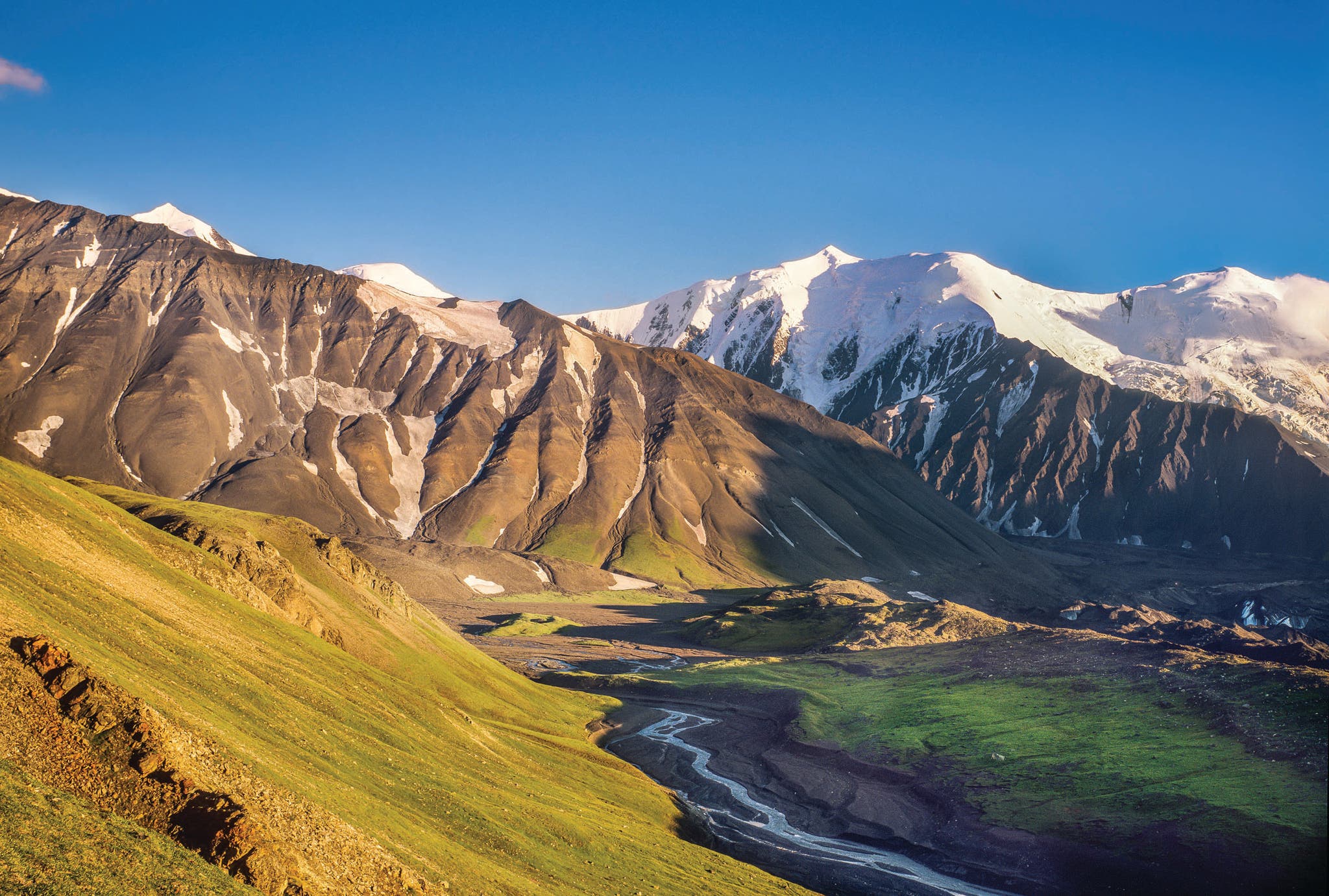
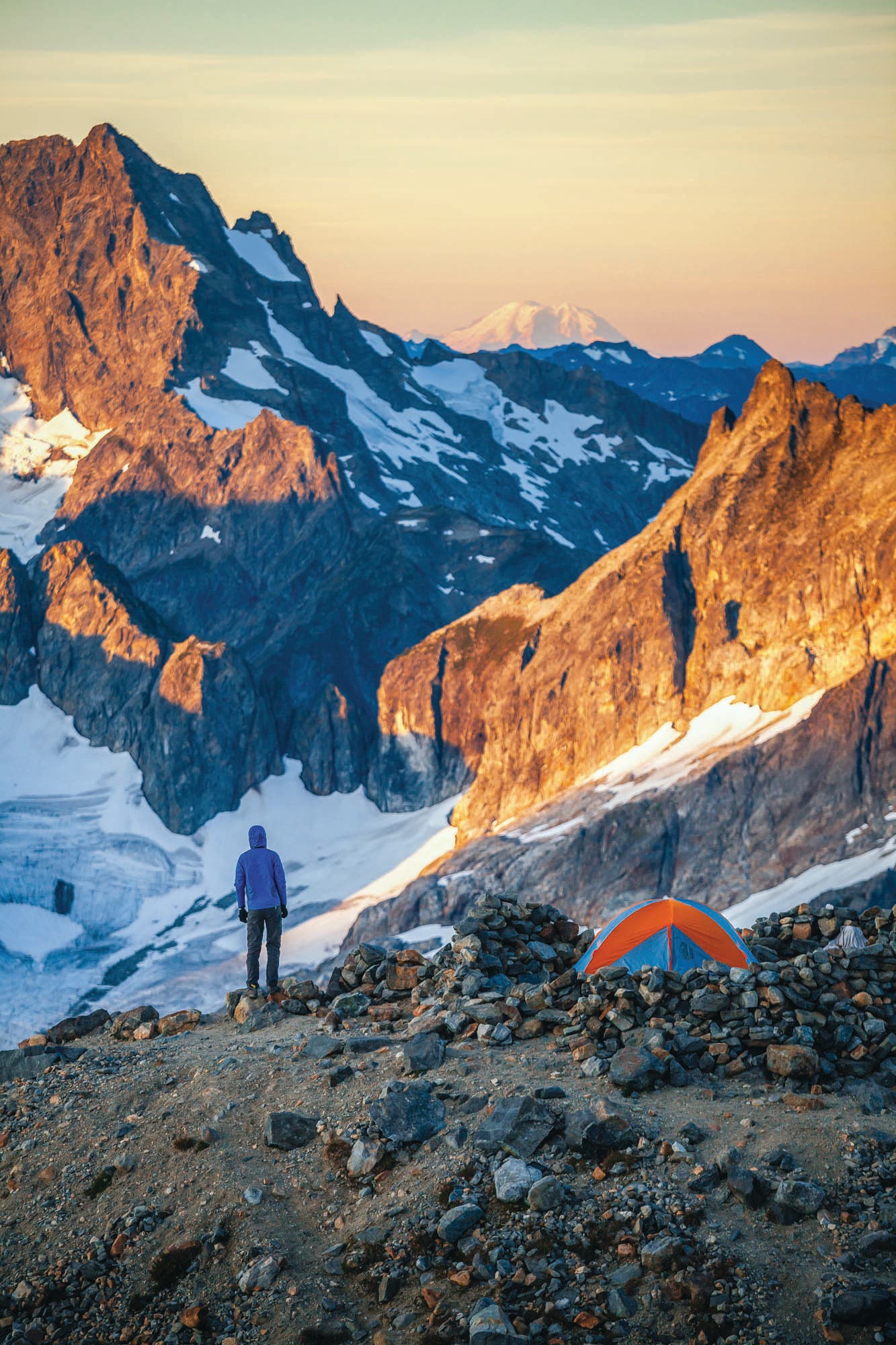
Mountain Perch: Anderson Pass, Denali National Park, Alaska
Don’t sweat it if you don’t see oft-shrouded Denali right away. Yes, the view of 20,000 vertical feet of rock and ice from 5,400-foot Anderson Pass is spectacular on bluebird days, but kicking back to see the Alaska Range create its own weather system is a once-in-a-lifetime experience all its own. As the mist peels off in waves from the snow-draped granite, keep an eye out for caribou and dall sheep passing by your tent as they cross one of the few non-technical passes in these mountains. When the clouds finally part, peer down: Cascading below either side of the pass are twin glaciers, the Muldrow and the West Fork. Wait up for dusk if you can (it can be a bit late in the land of the midnight sun) to watch the chiseled ridges hoard the dimming light. Get here from the Eielson Visitor Center by following the Gorge Creek Trail for 1 mile. Head cross-country along the Thorofare gravel bar for 2.7 miles to the mouth of Glacier Creek. Follow the creek upstream to where it’s swallowed up by the Muldrow Glacier. After crossing the second glacial tongue, turn east and climb 1,500 feet over 1.2 miles up to the pass. Set up your tent facing southwest—with a little luck, you just might get a glimpse of The Mountain come morning.
ADVERTISEMENT
Trailhead 63.4281, -150.3949 Get Here $33.25, check schedule Permit Free, walk in; limit of four per day
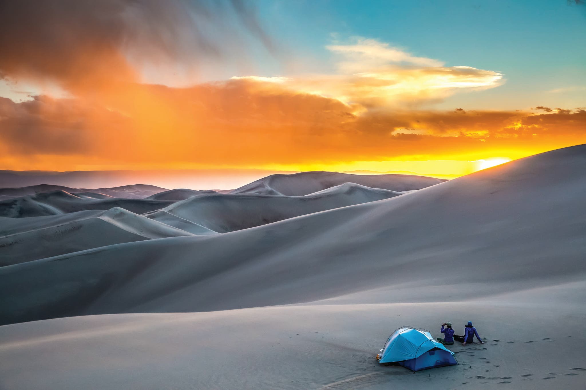
Choose Your Own Adventure: The Dunefield, Great Sand Dunes National Park and Preserve, Colorado
We promise it’s not a mirage. Sure, a few hundred feet of sand might not be quite as impressive on paper as one of the snow-capped 13ers to the north and east, but from your basecamp you’ll swear you’ve never seen anything quite like it. While your first glimpse of Great Sand Dunes is the Instabrag-worthy shot of 750-foot Star Dune (the tallest in North America) on the drive in, it isn’t until you find your own way through the dunefield that you really understand how formidable all that sand can be. Your quest starts from the horse lot by the Piñon Flats Campground. Hike upstream along the edges of the Medano creekbed for 5 miles until it meets Little Medano Creek, the last natural water source on your journey (though it may be dry in late summer; call ahead). From there, follow the creek north before turning west and selecting a dune in the distance to the south as your focal point. Use the good sight distance to pick your first few route choices, but be advised that your routefinding skills are about to be tested. Soon you’ll learn that carrying over a gallon of water through loose sand is no joke, but your sufferfest will be forgotten when you top out at the high ridge—and its view over a seemingly unending ocean of dunes with no trails and no people. Feel the glee of sprinting hundreds of feet down the other side of the ridge into the park’s backcountry before looking for a perfect campsite nestled among scattered Indian ricegrass and prairie sunflowers. (Orient your tent for east-facing views, the better to watch the Sangre de Cristo Range turn red at dawn). How far you hiked to get here, we won’t say—that’s your secret.
Trailhead 37.7444, -105.5036 Get Here Drive north on Highway 150 until you reach the visitor center Permit Purchase on Recreation.gov
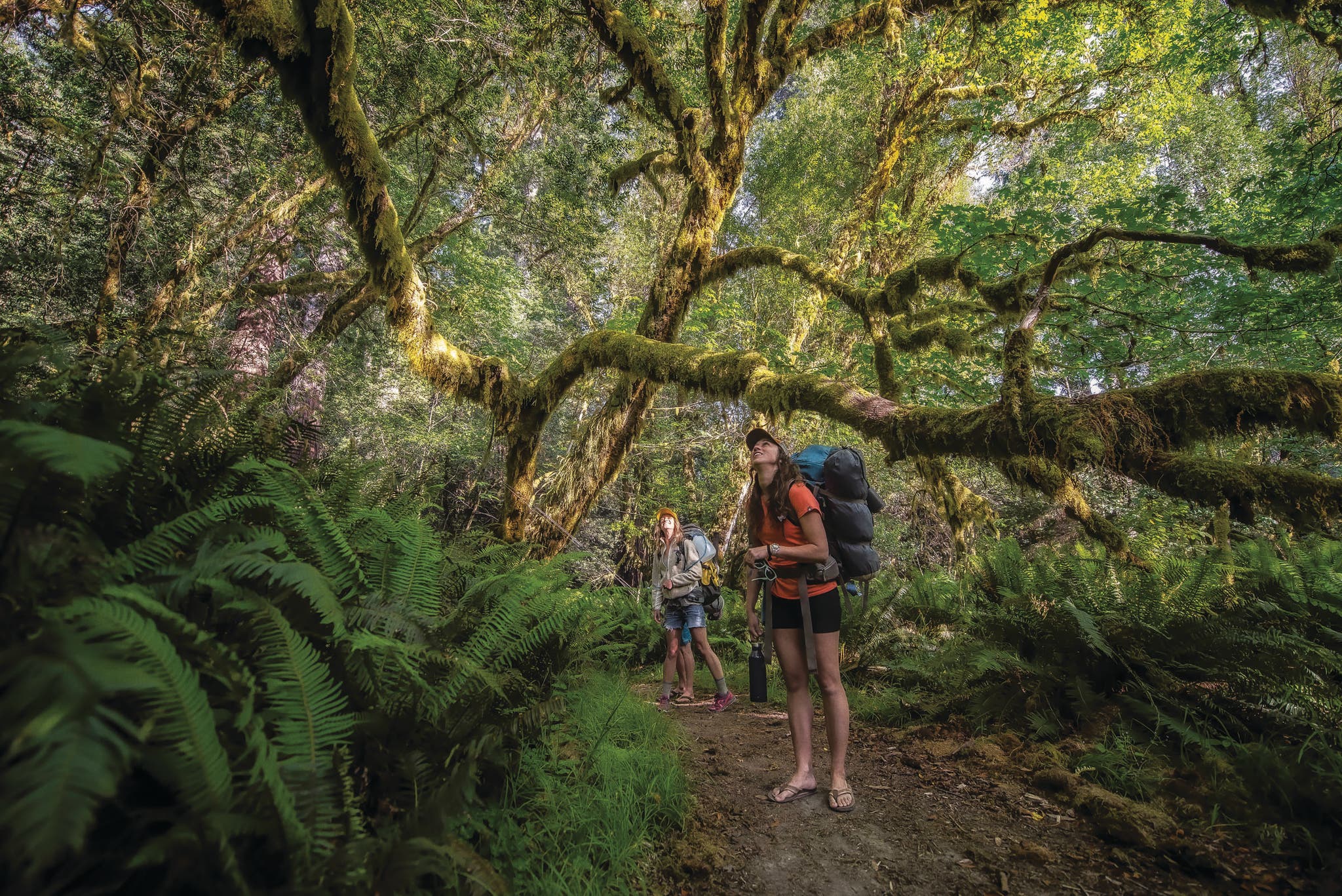
Climate Changers: Redwood Creek, Redwood National Park, California
Take a deep breath. What you’re smelling—earth, pine, and spice—is a byproduct of terpenes, a chemical released by redwoods to create the clouds they draw moisture from. Even on the sunniest days, the forest along the banks of Redwood Creek—home to the world’s tallest trees—can be shrouded in fog. Make this your sanctuary for a night by hiking the Emerald Ridge Trail. Hit Redwood Creek at mile 1.7 and leave the trail, following the creek downstream for .7 mile along the gravel bar. Set up camp beneath redwoods towering 300 feet high on a sandy bank just south of the Fog Creek outlet (be sure to stay a quarter-mile back from the Tall Tree Grove). Explore a forest of 5-foot-tall ferns and moss-covered maples interspersed with redwoods before cooling off in one of the swimming holes tucked into the bends of the creek. As the sun dips behind the canyon walls, listen to the red-legged frogs singing of summer. Linger at camp the next morning to spy resident elk stopping by Fog Creek for a long drink in paradise.
Trailhead 41.2082, -123.9931, Get Here Reserve a free permit to drive on the Tall Tree Access Road Permit Free, reserve online; max 50 people per day along Redwood Creek