Published October 23, 2008 05:35PM
Thru-Hike The Roadless Sierra
Check off the most remote miles in California's Range of Light.
'Beware whitewater crossings more than knee deep (Garrett Cotham).'
The Hike
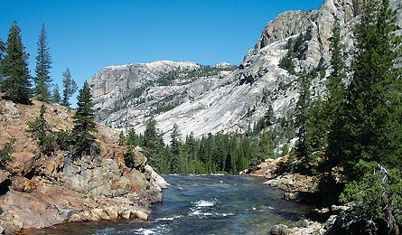
The best section of the most scenic long trail in the country is the 203.7-mile
stretch in the central Sierra from Kennedy Meadows Campground to Red’s Meadow
Campground. In that span, the PCT crosses Sequoia and Kings Canyon National
Parks and the John Muir Wilderness–and never meets a single road. It’s
the longest roadless span on any National Scenic Trail in the country. On the
way, you’ll have a chance to summit Mt. Whitney (the Lower 48’s highest point
at 14,497 feet) and experience the legendarily gentle weather of California’s
central Sierra. Plan for 10 to 15 days to cross this roller coaster of subalpine
and glaciated terrain.
The Crux
River crossings in high, fast, freezing water. After a heavy snow year, creeks
swell to 50 feet wide well into July.
The Key
Astute river scouting, patience, and a “got dunked” plan. The most challenging
streams are Evolution Creek, Bear Creek, and the North Fork of Mono Creek between
Muir Pass and Shelden Pass (miles 145, 162, and 175 respectively). The trail
doesn’t always intersect them at the best place to ford, so scout upstream for
shallower crossings. Evolution Creek, for example, is slower and braided into
smaller segments just a third of a mile upstream. But strength in numbers is
the real key, even if it means waiting for more hikers to show up. The most
stable river-crossing method is the tripod: Three hikers unclip their hipbelts,
place their arms on each other’s shoulders in a triangle formation, and cross
slowly with the strongest hiker forming the upstream “point” of the triangle.
Before you cross, be sure to look for downstream obstacles to avoid (like rocks,
waterfalls, downed logs) if you lose your footing. And if you do go for a swim,
immediately stop and warm up once you reach dry land: Build a small fire, make
a hot drink, and eat a calorie-dense snack, like peanut butter. Still chilled?
Do push-ups.
The Way
From Piersonville, take US 395 three miles north to J41, a dirt road leading
22 miles to Kennedy Meadows Campground. From Mammoth Lakes, take CA 203 (Minaret
Rd.) 13.1 miles to Red’s Meadow Campground.
Plan It
Check the Pacific Crest Trail Association (pcta.org)
for maps and Yogi’s PCT Handbook ($25, pcthandbook.com)
for on-trail beta.