The Other Way In

'Hermit Trail (photo by Laurence Parent)'
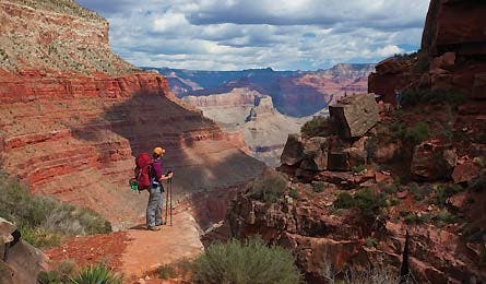
Hermit Trail (photo by Laurence Parent)
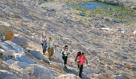
Cottonwood Lakes Trail (Chris Werner)
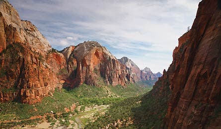
Angels Landing Trail (Scott Mansfield)
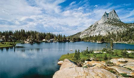
John Muir Trail (Londie G. Padelsky)
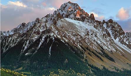
Mt. Sneffels (Glenn Randall)
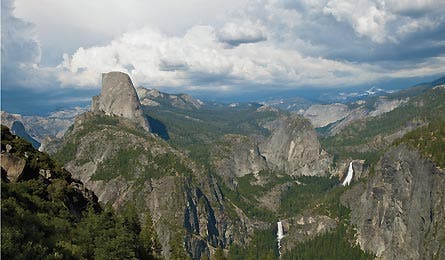
Half Dome (Dmitri Alexander)
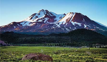
West Face Gully (Timothy Piya Trepetch)
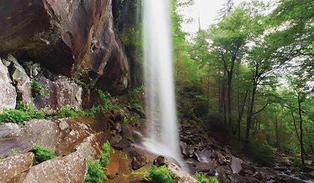
Rainbow Falls Trail (Kurdistan/Shutterstock)
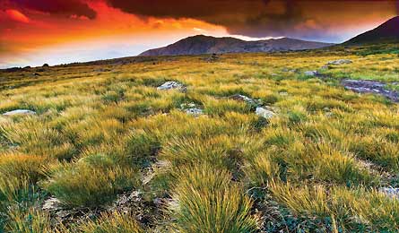
Huntington Ravine (Paul Rezendes)
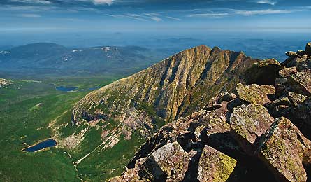
Mt. Katahdin (Michael Kormos)
Grand Canyon Rim to River
Grand Canyon National Park, AZ
X Trade route Bright Angel and South Kaibab Trails
→ Sneak route Hermit Trail
Key stats 19.4 miles, 8,620 feet elevation change, 1 campsite
Off-radar cred Your Hermit Trail hiking permit comes with a backpackers-only code to open the locked gate at the Hermits Rest Transfer, a quarter-mile from the trailhead.
The bad news: Every year, more than 88,000 people—roughly the seating capacity of the Rose Bowl—reserve a backcountry campsite below the Grand Canyon’s South Rim. The good news: Nearly half of them squeeze into just two sites along the South Kaibab and Bright Angel Trails corridors—the Bright Angel and Indian Gardens Campgrounds. Your avoidance plan? Hike this rough-around-the-edges trail to a single campsite on the Colorado River next to Hermit Rapids. The track is narrow, not regularly maintained, and sees frequent rockslides.
Do it From the Hermit trailhead, drop a steep 2,000 feet in the first 2.5 miles—don’t let the stunning cross-canyon views cause a stumble. The route continues with a few more big dips to the Cathedral Stairs at mile 3.5, then eases off on the vertical drop on the traverse to Hermit Creek campsite after 8.2 miles. The loose, rocky route looks nothing like it did in its pre-1930 glory days, when it served the luxury camp at Hermit Creek. While several inlaid stone sections remain as historic reminders, much of the trail has disintegrated over time. Indeed, in at least three places you’ll scramble across old rockslides that have obliterated the path (though the route is well-marked with cairns). Thanks to this lack of maintenance, you’ll get the same sweeping views of the canyon’s desert-palette walls and soaring buttes as in the crowded corridor, but without the human and mule traffic. Tank up on clear water at Hermit Creek, to avoid clogging your filter with the silty Colorado, then hike the last two miles down to the river and the beach campsite at Hermit Rapids. Your only company? Occasional boaters who pull off to scout the rapids before dropping in. From camp, retrace your steps. Best strategy for the return: Hike back up to the Hermit Creek campsite and spend a night before tackling the ascent, or get up early and punch out the 9.7 miles all the way back to the trailhead (warning: the exposed route is dangerously hot in summer).
Get there Hermits Rest trailhead is eight miles west of Grand Canyon Village on Hermit Rd.
MapBuy the BACKPACKER PRO MAP
Permit Required for all overnight stays below the rim. Apply early, starting the first of the month, four months prior to the proposed start month of your trip.
Contact (928) 638-7888; nps.gov/grca
Mt. Whitney
Inyo National Forest/Kings Canyon National Park, CA
X Trade route Mt. Whitney Trail
→ Sneak route Cottonwood Lakes Trail
Key stats 36 miles, 8,900 feet elevation gain
Off-radar cred A cross-country route to the standard summit trail
Highpoints are always hiker magnets, and the highest piece of rock in the Lower 48 is no exception. Add Whitney’s proximity to the Los Angeles metro area—plus a summit view taking in miles of Sierra granite—and no wonder demand is staggering for the grueling 22-mile round-trip to the top. The online lottery system for permits on the standard approach, the Mt. Whitney Trail, limits use to 60 overnight campers and 100 dayhikers per day in the summer (this year, the lottery opened February 1 and closed six weeks later). Avoid the crowds and permit hassle with this rugged, cross-country, four-day route, which tours the dramatic granite landscape and alpine lakes of the southern Sierra.
Do it Day one is big, so get an early start at the Cottonwood Lakes trailhead. First, cruise about a mile to follow pristine Cottonwood Creek, through pines and past the 400-foot-tall cliffs guarding High Lake (mile 6.5). Then head up and over 12,300-foot New Army Pass to dreamy campsites at picture-window-clear Lower Soldier Lake (mile 10.5), unnamed on maps but sitting at the base of The Major General, the southwest-facing granite buttress a mile north of New Army Pass. On day two, allow extra time to navigate cross-country above treeline (you’re off-trail from now until you join the Whitney Trail on summit day). Go 1.5 miles north up the Rock Creek drainage to Sky-Blue Lake. From here, angle to Crabtree Pass, then drop down to campsites at Crabtree Lakes and head to bed early. Get a headlamp start at 3 or 4 a.m. on summit day (depending on your speed). Leave camp with a daypack (layers, food, and jacket) to finish the last 2,500 vertical feet to Whitney’s top, climbing off-trail scree up the drainage south of Discovery Pinnacle (class 2). Then join the Whitney Trail for its final 2.5 miles to stand above the entire Sierra, and command views all the way to the desert floor nearly 11,000 feet below. Return to camp at Crabtree, or if you’ve still got legs, pack and descend to Lower Soldier Lake (with a smaller, solitude-guaranteed campsite on a tiny peninsula). Next day, retrace your path to the trailhead.
Get there From Lone Pine, take Whitney Portal Rd. three miles, to Horseshoe Meadow Rd. Turn south and go 20 miles to the trailhead.
MapBuy the BACKPACKER PRO MAP
Permit Required ($15); reserve up to 6 months in advance at recreation.gov. Click on “with Whitney visit” to secure access to the summit. Food storage Bear canisters required.
Contact (760) 873-2400; fs.usda.gov/inyo
Angels Landing
Zion National Park, UT
X Trade route Angels Landing Trail from Grotto trailhead
→ Sneak route West Rim Trail
Key stats 19.4 miles point-to-point, 3,100 feet of downhill
Off-radar cred Single-occupancy campsite 2.9 miles from the summit trail
When you reach the pinnacle of this 1,200-foot-high sandstone fin jutting out into the middle of the sheer red walls of Zion Canyon, it’s like standing on a pulpit in a cathedral of redrock. No surprise, then, that hordes of pilgrims line up to climb the Angels Landing Trail. The 2.5-mile path—which ascends quad-busting switchbacks and via ferrata chains—starts at the Grotto shuttle bus stop. See the iconic view without the crowded approach by coming in from the top, via the West Rim Trail, on a quiet overnight that connects with the Angels Landing Trail just .5 mile from the summit.
Do it Catch the Zion Shuttle at 6:50 a.m. at the Zion Adventure Company, .7 mile west of the main park entrance in Springdale, and get off at Lava Point. Detour out to Lava Point overlook to check out the teaser view of your route into the top of Zion Canyon before you head down the trail, then connect with the West Rim Trial via a .2-mile shortcut (look for Barney’s Trail on the left side of the Lava Point lookout). From here, the West Rim stays on top of Horse Pasture Plateau, then climbs up and out of a depression called Potato Hollow at mile five to views of the white sandstone fins and peaks of Great West Canyon. Fork right at mile six to stay on the West Rim. Reach camp at mile 11.1, and choose site #1 or #2 (room for one tent) for the best views of the canyon and to get closest to Angels Landing. The next day, get hiking at dawn for the lowest traffic on the final push. Stash your pack at the West Rim/Angels Landing junction, 2.9 miles from camp, where you’ll meet the Angels Landing Trail (the dayhiking rush begins around 9 a.m., especially on weekends). Brace for dizzying exposure along the last .5 mile as you grab several segments of chains for support. Traverse the top of a sandstone fin to reach the 360-degree viewpoint, and keep an eye peeled for the Grand Canyon condors that have migrated here. Last spring, a BACKPACKER editor watched one clean itself for an hour in a tree just below the top. On the way down, grab your pack and follow the mostly paved path 2.5 miles back to the Grotto trailhead. Take the Zion Canyon shuttle to the visitor center, then the Springdale shuttle (both free) back to your car.
Get there Take the Zion Shuttle ($39, zionadventures.com) to the West Rim trailhead.
MapBuy the BACKPACKER PRO MAP
Permit Required; get at the Backcountry Desk one day before, or reserve the 5th day of the month, two months prior ($10; zionpermits.nps.gov).
Contact (435) 772-3256; nps.gov/zion
Half Dome
Yosemite National Park, CA
X Trade route Half Dome Trail from Happy Isles
→ Sneak route John Muir Trail from Cathedral Lakes trailhead
Key stats 23 miles, 3,200 feet of gain
Off-radar cred A backpackers-only permit system for Half Dome’s Cable Route
Here’s all you need to know about the popularity of the standard route up Half Dome: In 2011, the park sold all of the permits for May and June weekends in just five minutes. Think weekdays offer a respite? Those went in 23 minutes. Do Bieber tickets even sell as fast? But happily, there’s a bureaucratic loophole just for backpackers: If you plan to make Half Dome part of an overnight hike, you can score a permit for the Cables Route when you get your wilderness permit. Take the “back way” from Tuolumne Meadows via the John Muir Trail on this 23-mile overnight shuttle hike (bonus: plenty of downhill), and end your long summit day in Yosemite Valley. You’ll have company on the two-mile spur to Half Dome itself, but you can avoid the masses by using your backcountry launching pad to get a head start (you’ll be six miles closer than dayhikers starting at Happy Isles).
Do it From the Cathedral Lakes trailhead, hike the rocky JMT through pine forest past the jagged granite sentinel Cathedral Peak. Go over 9,680-foot Cathedral Pass at mile 3.8, then descend through tree-ringed Long Meadow and past the cabins of the Sunrise High Sierra Camp. At about nine miles, you’ll begin a series of switchbacks that drop 500 feet. After the descent, look for good camping in established sites along Sunrise Creek. Next morning, get up early for your bid on Half Dome. Cache packs at the JMT/Half Dome Trail junction and finish the two-mile, 1,800-vertical-foot climb up the Half Dome Trail to the summit. (Pack durable gloves for the cables, and don’t attempt the ascent if the rock is wet.) Photo op: Head over to the Visor, the overhanging granite perch above Half Dome’s northwest face, with the granite buttresses and waterfalls of Yosemite Valley below. From the summit, you’ll drop 4,800 feet over eight miles to the Happy Isles trailhead.
Get there Park at the overnight parking lot behind Curry Village, then catch the Tuolumne Meadows Hikers Bus at Curry Village at 8 a.m. to reach the Cathedral Lakes/JMT trailhead by 10:20 a.m.
($15/person; reservations: 209-372-4386).
MapBuy the BACKPACKER PRO MAP
Permit Required. Wilderness permits: $5 + $5/person. Reserve starting 24 weeks in advance (ask for dispersed camping along the JMT from Cathedral Lakes trailhead). Half Dome permits: $5/person, given upon request to those whose wilderness permits “reasonably include Half Dome as part of their itinerary.” Contact (209) 372-0200; nps.gov/yose
Colorado Fourteener
X Trade peak Longs Peak
→ Sneak peak Mt. Sneffels
Key stats 4.8 miles, 3,000 feet of elevation gain, trailhead bivy
Off-radar cred A day’s drive keeps Denver’s summit-hungry population away.
There’s no other state in the country with as dense a concentration of peaks that rise to 14,000 feet or higher. Problem is, almost every hiker chooses the same one: Longs Peak, the tallest in Rocky Mountain National Park. And if not Longs, it’s another easy-access peak like Bierstadt, Grays, Torreys, or Quandary. Thousands of Denver peakbaggers swarm these five summits on summer weekends. But you can have your Fourteener and solitude, too. Just head to the jagged San Juan Mountains (six hours southwest of Denver), where this postcard peak lies way outside the crowd zone.
Do it Get an alpine start (sleep at a parking area bivy—at 11,350 feet—to help with altitude acclimatization), and hike .8 mile up a 4WD road to the trail. Here, you’ll climb above treeline and enter alpine tundra shortly thereafter. At the junction of the Blue Lakes Pass and Mt. Sneffels Trails, stay on Mt. Sneffels and head up and right toward the southwest-facing gully on the mountain’s east side. Work your way up talus toward Lavender Col (13,520 feet) and pop onto the saddle to a view of the craggy peaks of the San Juans—Teakettle Mountain, Coffeepot, and Potosi Peak. From the col, it’s 700 feet of boulder-hopping up the final gully. There is no defined path and conditions vary, so keep eyes peeled to find the safest route to the top, and wear a helmet to protect from rockfall. Don’t forget to look back down; the view south rivals any on a Longs Peak ascent. Top out at 14,150 feet—high above the sawtooth ridgelines and shimmering alpine lakes of one of the most rugged regions in the state. Late summer and early fall have minimal snow and ice; in spring and early summer, you’ll need crampons and an ice axe for the final snow-choked couloir.
Get there The hike begins 7.4 miles from Ouray. Head south on US 550, turning right onto Camp Bird Rd. and staying right as it turns to CR 26 and then Yankee Boy Basin Rd. Park after the junction of FR 853 1C and 853 1B. Walk the road .8 mile to the trailhead.
MapBuy the BACKPACKER PRO MAP
Permit None
Contact (970) 874-6600; fs.usda.gov/gmug
Mt. Washburn
Yellowstone National Park, WY
X Trade route Dunraven Pass and Chittenden Road Trails
→ Sneak route Washburn Spur Trail to Dunraven Pass trailhead Key stats 12 miles point-to-point, 2,450 feet of elevation gain
Off-radar cred “When they built this trail, they forgot the switchbacks,” says a staffer in the park’s backcountry office.
The hike to Mt. Washburn’s 10,223-foot summit, overlooking the Yellowstone Plateau, is the most popular full-day hike in the nation’s fourth-most-visited national park. But almost everyone takes the six-mile Chittenden Road Trail to the summit and back. Leave a car at the Dunraven Pass trailhead, drive down to the Glacial Boulder trailhead, and take the scenic route—you’ll have almost the entire nine-mile climb all to yourself, and enjoy wildflowers on the descent through the meadow on the other side.
Do it Follow the Glacial Boulder Trail as it parallels the Yellowstone River 1,000 feet below. After just a mile, look for the Silver Cord Cascade, dropping 900 feet on the other side of the canyon. Just before starting your climb up Washburn’s east ridge, you’ll pass the rarely visited Washburn Hot Springs, including the dark, rumbling waters of Inkpot Spring (soaking is illegal, and water can top 200°F). The majority of the trail’s 2,450 feet of climbing comes in the last 2.3 miles. Rest often and enjoy the private view of the Grand Canyon of the Yellowstone, far below. Join the Chittenden Road hikers for the last quarter-mile to the summit, which marks the northern end of the Yellowstone Caldera. Take the Dunraven Pass Trail down for the best wildflowers (late July and August) and catch purple monkeyflower and lupine, and yellow balsamroots, among several dozen other varieties.
Get there The Glacial Boulder trailhead is on the left side of the road to Inspiration Point, 1.4 miles east on North Rim Dr. from the intersection of Canyon Junction. Leave a shuttle car at the Dunraven Pass trailhead, 4.5 miles north of Canyon Junction on Grand Loop Road. No shuttle? Leave by sunrise, and do it as a 20.6-mile out-and-back.
MapBuy the BACKPACKER PRO MAP
Permit None required for day use
Contact (307) 344-7381; nps.gov/yell
Mt. Shasta
Shasta National Forest, CA
X Trade route Avalanche Gulch
→ Sneak route West Face Gully
Key stats 12 miles, 7,229 feet of
elevation gain
Off-radar cred Fewer than 10 percent of climbers use this route.
John Muir wrote that the first time he saw Mt. Shasta, “all my blood turned to wine.” We think that means, “I was drunk with desire to climb it.” Northern California’s crown jewel—at 14,162 feet, just a hair shorter than Rainier—has a similar affect on hikers today. The Forest Service estimates 8,000 people attempt to scale it annually, and 90 percent do it via the Avalanche Gulch route. Take the slightly steeper route up the West Face Gully (one drainage west), and you’ll feel like you have the volcano all to yourself—just like Muir.
Do it Hike from the Bunny Flat trailhead to Horse Camp at 7,900 feet, fill your water bottles with pure Shasta water at the spring there, and take the left fork behind Horse Camp Cabin. After about 1.5 miles of contouring north and up over several snowfields, set up camp on snow in the middle of Hidden Valley at 9,200 feet. Get an alpine start the next morning to crampon up hard snow in the West Face Gully (Cascade Gulch on some maps), the central gully above Hidden Valley. The crux of the ascent is 300 feet of 40- to 45-degree snow, which you’ll hit at about 9,500 feet. After that the angle eases, but the climbing is never “easy”: the slope stays between 35 and 40 degrees to the ridge at 13,200 feet. Traverse to the south of the Whitney Glacier to Misery Hill, where you’ll likely join climbers who chose the Avalanche Gulch route. Punch up Misery Hill to the fumaroles (steam vents) 100 feet below the rim, then top out on the small, rocky summit. On the return, plunge-step down the same snow slopes, and remove your crampons to glissade when comfortable. Gut check: ice axe, spikes, and self-arrest skills are a must on this route.
Get there From Mt. Shasta City, take Lake St. (stay left as it turns into Washington Dr. then Everitt Memorial Hwy.) 11.5 miles to the trailhead.
MapBuy the BACKPACKER PRO MAP
Permit Required for travel above 10,000 feet. Get self-issue, 3-day summit passes at the trailhead, $20. Contact (530) 226-2500; fs.usda.gov/stnf
Mt. Le Conte
Great Smoky Mountains National Park, TN
X Trade route Alum Cave Bluffs Trail
→ Sneak route Rainbow Falls Trail
Key stats 13.8 miles (one-way), 3,993 feet of elevation gain
Off-radar cred “Rocky tread and a remote trailhead drastically cut traffic,” says one backcountry office volunteer.
Ten thousand hikers head for the 6,593-foot summit of Mt. Le Conte annually. That’s the same as the number that attempt Mt. Rainier each year. The Le Conte crowd comes to soak in the iconic view of tree-studded ridges, which recede in waves for miles—and famously turn smoky blue under a gold-red horizon at sunset. That view is one of the main reasons reservations at the mountaintop LeConte Lodge fill by mid-February each year (the other is the included homestyle meals). Fortunately for solitude seekers, most trekkers take the Alum Cave Bluffs and Boulevard Trails. Your route: The Rainbow Falls Trail, which offers a sweet bonus, an afternoon rainbow produced by the 80-foot eponymous waterfall.
Do it From the Rainbow Falls trailhead, climb the rocky trail through 100-foot-tall hemlock trees along mossy, boulder-strewn Le Conte Creek. You’ll cross the creek three times before arriving at 80-foot-high Rainbow Falls, the park’s highest, at mile 2.8. Traffic drops off at Rainbow Falls, so enjoy the solitude on the switchbacks that climb to 5,700-foot Rocky Spur, on Le Conte’s northwest ridge. Cross over into the dense old-growth forest on the ridge’s north side and, just before the intersection with the Bull Head Trail (at mile six), look west over your shoulder to see valley towns almost 5,000 feet below. Join the Bull Head Trail for the last (easy) half-mile to the summit—and the LeConte Lodge, if you’ve made reservations for the night (leconte-lodge.com). Staying? Watch the sunset from Cliff Top, a .2-mile hike west from the lodge. Camping is also available at the Appalachian Trail shelter nearby; reserve up to a month in advance (865-436-1231). Returning? Catch the show at Rainbow Falls on your way down.
Get there From Gatlinburg, take Cherokee Orchard Rd. 2.9 miles south to Loop Rd. Reach the trailhead in .5 mile.
MapBuy the BACKPACKER PRO MAP
Permit Required for overnights
Contact (865) 436-1200; nps.gov/grsm
Mt. Washington
White Mountain National Forest, NH
X Trade route Tuckerman Ravine Trail
→ Sneak route Huntington Ravine
Key stats 8.5 miles (one-way), 4,280 feet of elevation gain
Off-radar cred The AMC’s White Mountain Guide discourages “novices” and those who “tend to feel queasy” with exposure.
With six trails, a paved road, and a cog railway leading to its summit, “popular” is a bit of an understatement. You can’t land a plane on top of Mt. Washington, but just about any other way to the top of the New England landmark is fair game. Get on the Tuckerman Ravine Trail in the summer or early fall and you’ll never be alone. But thankfully, the mountain is as big as its reputation—and amid all the trade routes lies a scrambley route reserved for fit hikers who’d rather climb up steep rock than plod along with the crowd, nose to tail. It has plenty of exposure to go with the class 3 scrambling, and Northwest editor Michael Lanza (born and raised 100 miles from here) calls it “the East’s toughest trail.”
Do it From the Pinkham Notch Visitor Center, hike 1.3 miles on the Tuckerman Ravine Trail to the junction with the Huntington Ravine Trail. Follow it through the gradually thinning spruce and fir forest to the level area at the bottom of the ravine, where you’ll find a jumble of large boulders. The real climbing starts here at mile 2.7. Pick your way up the chute to The Fan, a talus slope leading up to the right-slanting Central Gully (an ice-climb in winter). Follow yellow blazes up the slabby chute, finding cracks for hand- and footholds. As you exit the main gully at about 5,300 feet, take a left onto the Alpine Garden Trail, named for the alpine goldenrod, bluet, and other wildflowers that bloom in late July and August (they’re delicate; stay on the trail). Continue west on the Lion Head Trail (mile 3.6), and then pick up the Tuckerman Ravine Trail at mile four to gain the summit in .8 mile. (Aim to reach the top by 10 a.m. if you want to avoid the brunt of the car and railway traffic.) Rather than downclimbing your route (steep, and dangerous if wet), descend the more benign (hence well-trafficked) Tuckerman Ravine Trail. Best bet: mid- to late summer, in dry weather.
Get there From Gorham, take NH 16 10.5 miles north to Pinkham Notch Visitor Center.
MapBuy the BACKPACKER PRO MAP
Permit None required for day trips.
Contact (603) 536-6100; fs.usda.gov/whitemountain
Mt. Katahdin
Baxter State Park, ME
X Trade route Hunt Trail, Saddle Trail
→ Sneak route Abol Trail
Key stats Nine miles (one-way), 4,000 feet of elevation gain
Off-radar cred “This bouldery gash isn’t a trail by traditional standards,” says park naturalist Jean Hoekwater.
Climbing to Katahdin’s 5,270-foot summit is a rite of passage for Appalachian Trail thru-hikers, New England peakbaggers, Thoreau fans (he climbed it in 1846), and anyone who wants to test himself on the granite monolith. As AT pioneer Earl Shaffer said after he reached the top, “Already I knew that many times I would want to be back again—on the cloud-high hills where the whole world lies below and far away.” None of the routes winding up and between the four glacial cirques on the mountain’s flanks is secret, but you’ll find the fewest people on the Abol Trail. It’s the most challenging, naturally, so bring your scrambling skills for the Abol Slide (slabs and talus exposed after a 19th-century avalanche), and strong quads for the 4,000 feet of elevation gain.
Do it From the Abol trailhead 5.8 miles from the Togue Gate at Baxter State Park, follow the blue-blazed trail through the spruce forest for 1.5 miles, and enter the bottom of the Abol Slide. The steep jumble of boulders and scree continues for more than a mile up Katahdin’s daunting south face, having poured down the mountain in a great avalanche in 1816. Move carefully up the stairstep-like rockslide, mindful to not dislodge loose rock onto hikers beneath you. As you gain elevation and escape the trees, watch as the view of the forest floor opens behind you—and as the boulders of the steep Abol Slide disappear over the edge into the trees below. At the intersection with the AT, exit the Slide onto the football-field-size Tableland and scope the rest of the route one mile along the ridge to the summit. There, you’ll get 360-degree views of the green carpet of trees pocketed with lakes far below, including Chimney Pond, nearly a vertical-half-mile down to the northeast. Descend the gentler, knee-friendly Appalachian Trail/Hunt Trail and walk the road 1.5 miles back to the Abol trailhead. Skip the Abol Slide if showers are in the forecast.
Get there From Millnocket, drive 17 miles northeast on Baxter State Park Rd. to the Togue Gate. Take the left fork and drive 5.8 miles to the Abol trailhead.
MapBuy the BACKPACKER PRO MAP
Permit None; trailhead parking is limited. Reserve one of the 16 parking spaces ($5, two weeks or less prior to date for non-Maine residents; starting April 1 for Mainers) at baxterstateparkauthority.com. Unreserved spaces will be filled first-come, first-serve as soon as the Togue Gate opens at 5 a.m. Alternately, camp at the Abol Campground (reservations fill up three months in advance).
Contact (207) 723-5140; baxterstateparkauthority.com