Updated December 3, 2024 11:54PM
The CDT Project
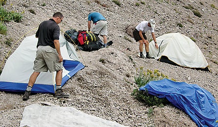
We sent 209 readers out to GPS the Continental Divide Trail, the biggest, baddest long-distance path of them all. They brought back the makings of the first authoritative map of this American classic. These are their stories–and their favorite sections.
'cdt15_445x260.jpg'
What’s the first thing you do when planning a backcountry trip? Consult a map. You check distances, scan for campsites, mark the best water sources, calculate elevation gain.
Not so with the Continental Divide Trail. Until now, you would have searched in vain for a land manager-approved guide to this transcontinental gem. Why? For one thing, mapping 3,000-plus rugged miles is a mammoth project. For another, the CDT, unlike the Appalachian and Pacific Crest Trails, is only 67 percent complete. That’s left huge segments where hikers have had to design their own course. And even the “finished” parts have been ambiguous: Many sections are poorly marked, and three different locations along the Mexico border vie for the title of southern terminus.
To rectify the situation, we asked BACKPACKER readers to help us collect GPS tracks, photos, and notes for sections of the route. Nearly 3,000 responded, every one of them eager to explore little-trod territory and create something of lasting value. Entries came from geologists, 30-year trail veterans, wilderness guides–an incredible pool from which we handpicked the folks on the following pages. The first team hit New Mexico last April; all told, we provided 50 teams with GPS units, training, and up to 65 miles of trail to map.
ADVERTISEMENT
Their adventures produced the most accurate data to date on the CDT. But it didn’t come easily: Some teams got lost, others suffered dehydration, and a few cursed us as they navigated tough terrain and bandaged blisters. But most created lifelong friendships, a few found salvation, and almost all came back with incredible tales.
Team 1
New Mexico, 52 miles, NM 35 to Caledonia Trailhead
Ken Haag knew his CDT assignment would kick his butt. The five-day section through New Mexico’s Gila National Forest and Aldo Leopold Wilderness is known for its poor signage, downed trees, and scarce water. And with Truth or Consequences (the nearest town) a four-hour drive from the trailhead, he realized he couldn’t count on help should anything go awry. By the time Haag, a pharmaceutical sales rep and former Army captain, joined team members Matt Feeney, Steve Taranowski, and Jason Childre at a remote ranger station, he’d steeled himself for the worst.
ADVERTISEMENT
The first few miles were gravy. The late May weather was mild, the mountain forest thick and fragrant, and the trail faint but discernible. But beyond 10,015-foot Reed’s Peak, the CDT’s high point in New Mexico, the hike turned hellish. Haag’s team entered a vast burn where jackstrawed piles of downed trees littered the landscape. Scrambling over, under, and around them was “like tackling a military obstacle course,” Haag says. Carrying nine liters of water apiece, they staggered under 60-pound loads. At first, they counted each downed tree out loud to pass the time. At 300, Haag kept track in his head. Two days, 25 miles, and 600 uprooted stumps later, they arrived at their vehicle, exhausted and amazed at how trail-less the CDT can be. “These mountains are positively beautiful,” says Haag, “but this section is in terrible shape.” The few markers they spotted were broken or fallen, and the deadfall in the Aldo Leopold Wilderness was almost impassable. “If they’re going to call it a trail,” says Haag, “then it needs to be a trail.”
Through the ordeal, Haag gained three new friends; the team is planning annual backpacking reunions. Even better, he reports, “I can tell my grandkids I helped map the CDT.”
Team 40
Idaho/Montana, 65 miles, Bannack Pass to Bannock Pass
Downed trees weren’t a problem for Dwight Worthington, but he gave up trying to count the wildlife he spotted along his team’s five-day segment from Idaho’s Bannack Pass to Montana’s Bannock Pass. “Plus, we had good views, nice campsites, and no one on the trail,” says Worthington. His wife, Marita, and friend Darrel Wharton joined the team, along with three llamas, two horses, and two dogs.
ADVERTISEMENT
Thanks to the pack animals, which each hauled about 60 pounds of food and gear, “we ate pretty good,” admits Worthington. They also helped alert the team to the presence of wildlife: Camped near Deadman Lake (at 8,000 feet on day one), they followed the llamas’ gaze to a big bull moose. Later, they watched 300 elk grazing along the Montana border, and spied a lone bull frolicking in the snow. Worthington even glimpsed a wolf above Tex Creek.
Dwight and Marita have llama-packed Idaho’s backcountry for 23 years, but mapping their favorite wilderness presented fresh challenges. “It was fun not knowing exactly where the trail went and having to search for it,” Worthington says. In the end, the rewards far exceeded the effort. The team enjoyed clear skies and big mountain vistas. They skimmed grassy ridgelines and sat atop the Divide. They gazed over a sea of snowcapped peaks and basked in complete solitude. And they paused longer than usual to appreciate a stirring view when the morning sun lit up the granite faces above their third camp. “A long mountain hike is like drinking a good aged wine,” says Worthington. “You don’t hurry it.”
Team 17
Colorado, 37 miles, Stony Pass to Spring Creek Pass
Karst Hogeboom doesn’t have to scrounge for hiking partners. The Rhode Islander hangs with guys who frequently hit the trail with their kids. Case in point: John Parsons, who just completed the AT with Hogeboom’s 20-year-old son Maarten. When the posse heard BACKPACKER’s call, they offered to pit their Appalachian moxie against the San Juans’ much higher, much more jagged peaks. Fellow Rhode Islander Dick Gregory and Colorado’s Mark Gingrich joined Parsons and the Hogebooms. They expected thin air–their route stayed between 10,800 and 13,400 feet–but they were unprepared for the millions of wildflowers. “Everyone said we should’ve been there two weeks earlier,” Karst says, “but what we saw was pretty amazing.”
ADVERTISEMENT
Each hiker assumed a different role on the expedition. Gingrich: videographer. Karst: team leader and photographer. Maarten: GPS guy. Parsons and Gregory: note takers. “It was a real team effort,” Karst recalls. “We had a blast thinking our efforts were going to help other people.”
Team 36
Montana/Wyoming, 64 miles, Targhee Pass to Old Faithful
Some trips test your mettle and flood you with the glow of mild victory. Others call on every survival instinct and scare the crap out of you. Catherine Cox got the latter when her team endured a 42-mile-long waterless death march. Kurt Elvert, Erik Hansen, JC Harlan, Steffan Fay, and Cox had heard that water might be scarce here last July, but they figured the longest stretch between refills would be 11 miles. Unbeknownst to them, severe drought had changed all that.
ADVERTISEMENT
On the first day, Cox’s team hiked 15 miles before finding water at the South Fork of the Madison River. Each person filled three liters, hoping it would last them to Summit Lake, two days’ walk and 40 miles away. It did–but barely. Rocky, obsidian-colored terrain amplified the 90°F temps. They breathed through their noses to reduce moisture loss. By noon on the third day, the hikers had only 1.5 liters between them. Summit Lake was still eight miles away.
As her thirst intensified, Cox obsessed about finding water–not the CDT. Several times, the team branched off the trail hoping to locate a stream, but their detours only added more mileage. When they finally reached Summit Lake, they were nearly stumbling in a dehydrated stupor.
Cox hiked the last 10 miles in an elated fog. The team had sufffered, but it had mapped a key segment and gained some toughness to call on in future epics. And what started out rough ended with a bang: Just as the team reached Old Faithful, a great geyser of steaming water shot into the air.
Team 35b
Yellowstone, 24 miles, Old Faithful to Lewis Lake
When Kevin Anderson introduced himself to his team, a silence fell over the group. He’d been a backpacker his whole life, and had thru-hiked the John Muir Trail as a teen. But starting this three-day journey, he was a broken man. His son, Ivan, had died recently playing basketball. Anderson wanted to map the CDT, but he also needed a release from the grief that had gripped him for months.
ADVERTISEMENT
It was a bittersweet assignment: Anderson and his son had often talked about hiking to Shoshone Lake, a highlight of this section. And Yellowstone didn’t disappoint. The team, which included Bev Wert, Mary McKinney, and Jason Wozniak, glimpsed wolf and bear tracks. They peered into thermal pools of pearlescent water that appeared bottomless. And they saw more than 100 geysers and fumaroles.
One night, Anderson wandered away from the team’s camp near the Lewis River outlet. It had been a long, hot day, so he waded into the water. Impulsively, he plunged in. “I emerged feeling emotionally baptized, clean and pure,” recalls Anderson. “The sadness and grief were washed away with the sweat and dirt, and for the first time since Ivan’s death, I experienced an unqualified joy. I realized that he would always be my son, I would always be his father, and in this way, love is and always will be stronger and more powerful than death.”
Best of the Best
4 solitude-blessed sections for your CDT life list
Touch the Sky
Copper Mountain to Bakerville, Colorado
6 days, 68 miles, mapped by Team 23
Tread the Rockies’ rooftop on this spectacular trek through the Front Range. It’s six days of alpine splendor: Mountain goats skip through wildflower fields, mining ruins abound, and steely summits rise in all directions. Charge your camera battery, pack a windshell, and soar up a route that rambles mostly between 10,000 and 13,000 feet.
ADVERTISEMENT
Day one starts with a three-mile climb through conifers, then crosses the exposed talus fields of the Tenmile Range. Camp below treeline near Miners Creek. On day two, you’ll wind across wooded slopes overlooking the Swan River and hunker down for the night among the pines above Horseshoe Gulch. Day three’s route stays just below treeline but peeks through openings back across the Tenmile Range. On day four, you enter the alpine zone where 13,370-foot Mt. Guyot looms above flower-filled tundra and marmots whistle at you. “We saw herds of mountain goats,” says team leader Katie Richards, “and one even came within seven feet of us.” After crossing the Continental Divide, scale 14,270-foot Grays Peak for views over two watersheds. Follow Stevens Gulch down to Bakerville to finish.
Beta
For more trail details, plus photos, an interactive (and printable) map, and driving directions, go to backpacker.com/cdt/copper.
Cruise the Desert
Mexico border to Hachita, New Mexico
4 days, 51 miles, mapped by Team 9
“This section is one of the last remaining outposts where you can still glimpse the Old West,” reports mapper Andrew Matranga, who charted this rugged tour de force through the creosote flats and cholla jungles of New Mexico’s boot heel. Here, the desert reveals its Jekyll-and-Hyde dualism. Some moments, it envelops you in a tranquil, gold-streaked sunrise; other times, it lashes you with skin-scouring winds. If you go, cache water, buy a wide-brimmed hat, and wear low gaiters to guard against sand and cactus needles.
ADVERTISEMENT
The flat terrain means you can log big miles, but scant water means you’ll carry hefty loads. From the Crazy Cook Monument, which marks the CDT’s official southern terminus, the path crawls northwest across sagebrush flats to the Big Hatchet Mountains. Camp at the mouth of Sheridan Canyon, 17 miles from the border, where a shade tree blocks the sun. On day two, trek across a windblown landscape and paved NM 81 to camp at Granite Pass, overlooking the Little Hatchets. The next day runs through rock gardens with foot-long lizards, then past Broken Jug Pass, Hachita Peak, and an 1880s mining encampment. Cross the Continental Divide–here, it’s an indistinct point on the plain–then press on to NM 9 and your hike’s end.
Beta
backpacker.com/cdt/mexico
Soar Above the Cirque
Big Sandy to Green River Lakes, Wyoming
5 days, 65 miles, mapped by Team 32
Hovering above treeline at elevations from 9,100 to 11,118 feet, this well-marked segment through the Wind Rivers doesn’t just deliver awesome panoramas. It also makes you a weather forecaster. “You could see thunderstorms coming from miles away,” says co-leader Leon Nelson. And from your high point at Hat Knob, you get a unique, eagle’s-eye view over the Cirque of the Towers, a line of jagged granite monoliths that most hikers admire from below.
ADVERTISEMENT
From Big Sandy trailhead, follow the CDT northwest for 11 miles as it gradually gains elevation. Camp on a grassy bluff overlooking the meandering East Fork River; come morning, the rising sun burns off the mountains’ chill at this open, east-facing site. Day two starts with a stiff climb to 10,500 feet and undulates across mountain-rimmed tundra where sheep graze. After eight miles, pitch your tent among the evergreens at Raid Lake. On day three, hike 11 miles to August Lake, then cross Hat Pass to peer down over the Cirque’s spires before ending your trip at Boulder Lake Campground.
Beta
backpacker.com/cdt/bigsandy
Mosey Through Montana
Trailhead 17 to Trailhead 10, Montana
5 days, 65 miles, mapped by Team 47
This little-hiked segment delivers a depth of solitude that belies its 30-minute proximity to Butte. That’s because thru-hikers typically eschew these east-west miles through the Anaconda-Pintler Wilderness in favor of a north-south detour that gets them to Canada faster. That’s good news for anyone not border-bound. For you, there are lakeside campsites, evergreen and larch forests, and a reviving burn area–all uninterrupted by other campers.
ADVERTISEMENT
Rounded, tree-topped mountains that rise to 10,000 feet define this landscape, giving it a truly remote feel. Yet the forgiving elevation profile and well-maintained trail allowed the team to average 13 miles a day. The trek starts at Trailhead 17 and occasionally escapes the trees to skirt alpine plateaus and rocky knobs offering wide views over the valley below. “Some of those rocks were as big as houses,” reports team leader Kevin Kondrat, who also spied elk and mountain lion tracks. By day four, after hiking 40 miles, you traverse swampy lowlands and stands of fluttering aspen. The final 10 miles (on day five) cross a broad meadow that drops gently to Trailhead 10.
Beta backpacker.com/cdt/butte
Join the Cause
The Continental Divide Trail Alliance says $45 million is needed to survey and build the remaining 1,043 miles of trail. With aggressive fundraising and some federal aid, the CDTA hopes to complete it in five years. Here are three ways you can help make this path more accessible to other hikers:
1.Sign up for a weekend or weeklong CDT trail-building vacation at cdtrail.org.
2.Volunteer to help us map more sections at backpacker.com/cdt.
3.Become a CDTA member or send a check.