Heading out the door? Read this article on the new Outside+ app available now on iOS devices for members! Download the app.
Not everyone has the time to hike a long trail. But if you have a day or two, you can easily sample some of their best parts. There are dozens of lists online breaking down the best segments of some of the United States’ marquee hikes (see our breakdown of the best 100 miles of the Appalachian Trail for an example). For this story, we got a little more personal, asking our editors to pick the single best long trail segment they’d ever hiked. This is what they said.
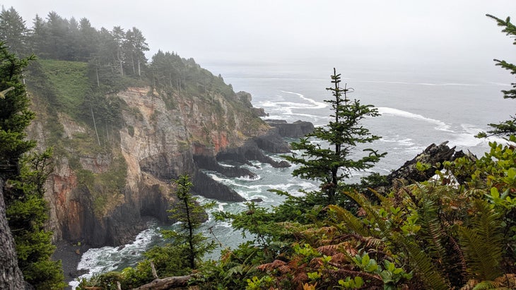
Oswald West State Park, Oregon Coast Trail
There’s a point about a third of the way through the section of the Oregon Coast Trail that crosses Oswald West State Park where hikers get their first glimpse of the sea. After a couple of hours walking through a dense rainforest carpeted with ferns and moss and dripping with lichen, the scenery opens up to reveal Cape Falcon plunging 200 feet into the Pacific below. When I hiked it in 2022 with my son, Rhys, it was the first of many views that stopped me in my tracks.
The Oregon Coast Trail is never remote, rarely venturing more than a mile or two from US-101 as the crow flies, and thru-hikers who do the whole thing still have to contend with some hair-raising road walks along that highway’s shoulder. But it’s also never unlovely: This is a buffet of some of the most beautiful coastlines in America, all jutting sea stacks and misty beaches. The 12-mile segment through Oswald West is a concise argument for why the OCT rocks. After passing Cape Falcon, the trail continues to trace the edge of the sea cliffs until it reaches Short Sand Beach, a stretch of shoreline that, at just about a third of a mile from the nearest parking, was much emptier when we visited than it had any right to be. From there, the path climbs back up to the clifftops before veering inland and switchbacking its way up the flanks of 1,600-foot Neahkahnie Mountain, the highest point along the trail. Up there, the forest thins into wide-open pine; that was the spot where we finally broke through the coastal fog and got our first unimpeded view to the horizon. By the time we reached the trailhead on the park’s southern edge, we had spent just a half-day on the trail, but it felt like we had made a month’s worth of memories. –Adam Roy, Editor-in-Chief
Eagle Rock, Pacific Crest Trail
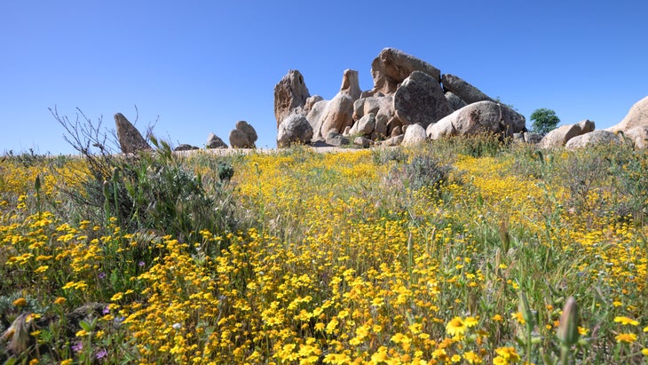
By the time you get a few miles past the southern terminus, you might be thinking there’s not much going on in Section A of the Pacific Crest Trail. You’re hundreds of miles from the Sierra, you’re not at the first mountain pass quite yet, and there are long, dry stretches where you need to be proactive about your water supply. However, take it from a local: One of the coolest natural rock formations in the country is in the final few miles of Section A.
You’ll never be bored on this hike: Section A’s northernmost 10 miles alone take you through a sampler platter of different ecosystems with varying steeps. (San Diego is the most biodiverse county in the Lower 48, after all.) After descending the scrub-covered San Felipe Hills and crossing Montezuma Valley Road, the trail follows a skinny singletrack between rolling green—depending on the time of year you hike—hills reminiscent of Ireland. There are even grazing cows in the distance. Then, corridors of riparian oak surround the trail as it grazes San Ysidro Creek. Then, the trail opens up once again to prairie-like flatlands just as you encounter Eagle Rock. It’s hard to imagine that the 20-foot-tall rock, which looks like the bird of prey with its wings fully outstretched, is natural. Each time I return to this section of the trail, I take a long lunch break facing it. To me, it’s more impressive than the famous rock formations in Utah. Note: Lots of hikers scale the back of the bird to get a picture while standing on its shoulders, but you shouldn’t. In 2022, members of the Kuupangaxwichem tribe wrote to the Pacific Crest Trail Association asking hikers to treat the sacred area with respect by no longer climbing it or leaving trash. —Emma Veidt, Associate Editor
Park Butte, Pacific Northwest Trail
I first discovered the joys of hiking on sections of the Appalachian Trail in New England, but I recently found that a different long trail runs right through my new backyard in Washington. Less than 10 miles from my house, the Pacific Northwest Trail crosses just south of Lake Whatcom, where I spend summer afternoons swimming and paddling. Without realizing it, I’ve been exploring sections of the PNT for the past three years. It crosses right through the Mt. Baker Ski Area, where I frequent all winter. It crosses Oyster Dome, my favorite local hike to show visitors the wonders of the Chuckanut Mountains and Bellingham Bay. And many of my bucket-list hikes for the upcoming backpacking season cross the PNT.
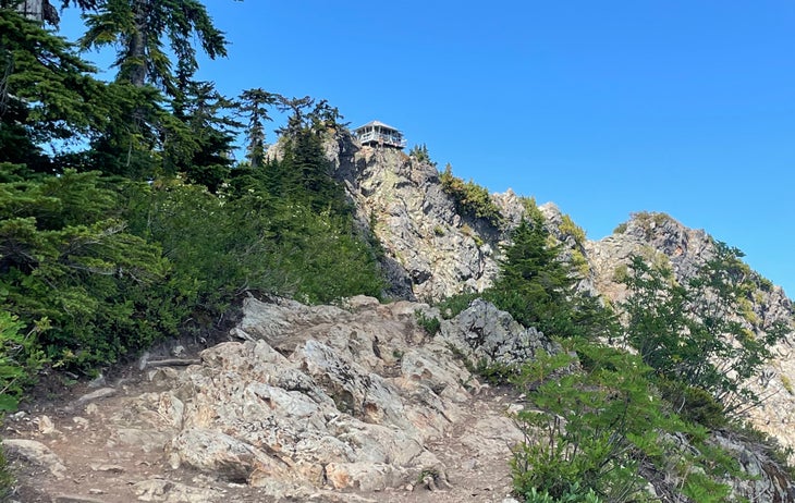
While it’s hard to choose a favorite of the sections I’ve experienced, I’d recommend the section to the Park Butte fire lookout on the south side of Mt. Baker. It’s a perfect sampling of all the North Cascades have to offer. From the parking area at the end of Forest Road 13 (which the PNT overlaps), first hike through meadows packed with wildflowers in summer and blueberries and huckleberries in fall. (Bring a bucket during berry season, or snack as you go.) During climbing season, you’ll see parties of mountaineers making the approach to Mt. Baker’s Easton Glacier. The snow-covered volcano towers over you as you climb toward the lookout, passing a series of tarns along the way. At the ridgetop lookout cabin, you’ll be treated to unmatched views of the North Cascades from the deck. Campers who arrive early can stay the night at the lookout on a first-come first-served basis. At 7.5 miles roundtrip, Park Butte makes a great dayhike, too. —Zoe Gates, Senior Editor
From 2025