Published September 14, 2021 04:34PM
Step Aside Presi Traverse, This Hike is the East's Toughest Challenge
With more than 17,000 feet of elevation change in 25 miles, this hike will push you to your limit.

View from Cascade Mountain in the Adirondack High Peaks. (Photo: Nick Pedersen/Stone)
In Superlative Hikes, we search out the biggest, wettest, and beariest trails in America.
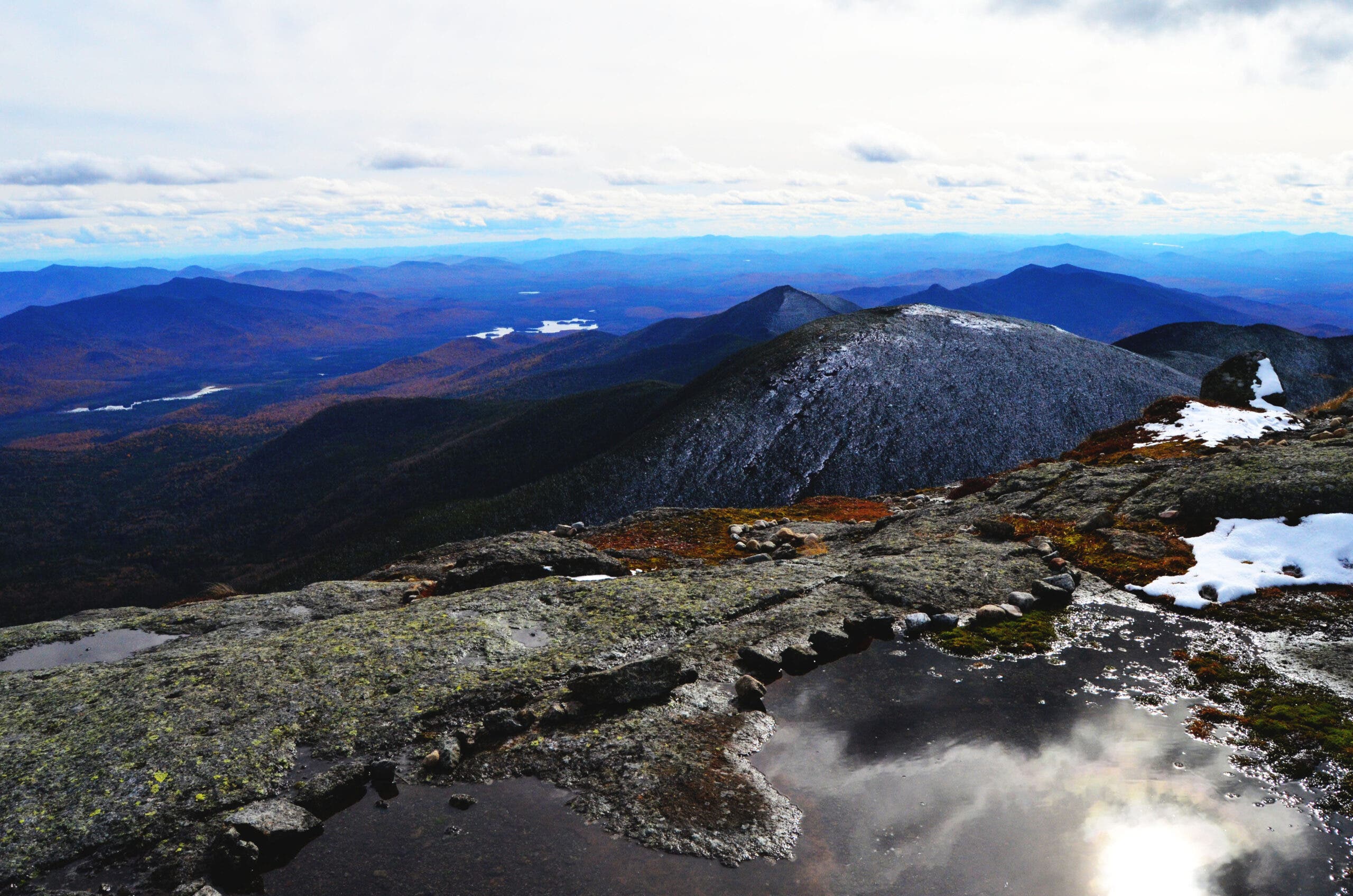
Seventeen thousand feet of elevation change in 25 miles. Yes, you read that right: The Adirondacks’ Great Range Traverse heads up and over nine peaks, six of which are over 4,000 feet, and that’s not counting all the false summits and cols in between, before finishing with an ascent of New York’s highest mountain. Even split over a weekend it’s a tough route, though the particularly ambitious can do it in a day.
The Great Range Traverse isn’t all suffering, though. With that many high peaks all in a row, you’re guaranteed views, and they are well worth the climb. The Adirondacks spread all around you from every peak and connecting ridgeline, sprawling hills blue-green with forest and crystalline lakes. Several stretches of the trail follow rocky, open ridgelines, where you can enjoy the panorama without having to pause at a viewpoint. The route itself has some fun bits, too, with several slabby scrambles, a few ladders, and one long granite section with a cable to aid climbers. The price in exertion (and sore muscles) might be high, but the Great Range Traverse is well worth it.
A Presidential Summit
At 5,344 feet, Mt. Marcy is the highest peak in New York. It’s known as Tewawe’éstha, meaning “it pierces,” in Mohawk, and Tahawus, meaning “cloud-splitter,” in Algonquin. The name Marcy comes from a 19th-century New York governor named William Marcy who authorized the environmental survey of the area. President Theodore Roosevelt went to his hunting camp in the nearby now-ghost town of Tahawus after summiting Mt. Marcy in 1901, only to be informed that President McKinley had taken a turn for the worse. After hiking 10 miles down the mountain with the rest of his party, he was told that McKinley had passed and hopped on the train to Buffalo to be sworn in as the 26th President of the United States.
ADVERTISEMENT
The Trail
Start from the Roostercomb trailhead in Keene Valley, off route 73 (parking permits required during the summer months). Pass a small pond after leaving the trailhead, then start the first climb of the day to the summit of Roostercomb. At mile 1.9, take a right at a junction. Continue to the summit at mile 2.2, then drop down into the woods again. Return to the last trail junction, this time turning onto the Hedgehog trail. Start climbing again to the top of Hedgehog Peak, then head into the high mountains.
Mile 5.2 marks the top of the first 4,000-foot peak on the route, Lower Wolfjaw. The next summit is Upper Wolfjaw at mile 6.3, where views of the next two peaks on your route await. Head up a few scrambles and ladders to Armstrong, the next mountain on the route, then head above treeline on the top of Gothics Mountain. The descent from Gothics is rocky and exposed; this is the section with a cable in place to aid hikers. Once you’re off the cables, head straight at a junction with the Orebed Brook Trail. Climb again to Saddleback Peak, then carefully descend the Saddleback Cliffs, testing each hand and foothold before continuing. Head upwards again to Basin Peak, where you can see the last two peaks of the day from the summit. At mile 9.5, Haystack Brook provides a consistent water source (there’s a campsite here too, for those splitting the route into more than one day). Climb to the top of Little Haystack and then Haystack, the third-highest peak in the state. Finish up with an ascent of Mt. Marcy, then head 8.3 miles out to Garden Trailhead. A 2-mile road walk brings you back to Roostercomb trailhead and your car.