Published September 20, 2013 05:34AM
St. Louis, MO: Pere Marquette
An exposed fault above the Illinois River and 30-mile views of St. Louis make this 3.5-mile loop in Illinois' largest state park a worthwhile escape from the Gateway City.
This clockwise loop combines three trails in Pere Marquette’s 12-mile system. From the visitors center, begin on the Goat Cliff Trail (and look for bluebells and red trillium in its lower portion during the spring). Here, you’ll climb beneath the remnants of the 60-mile Cap-au-Gres fault toward a lookout platform at mile 0.8 and the top of 828-foot McAdams Peak at mile 1.2. Views of the Illinois River valley from this ancient Indian burial ground explain its long-held sacred appeal and make for an excellent picnic backdrop.
Just below the peak, the route turns east on the wide, easy Hickory Trail toward Twin Mounds. This spot offers another dramatic view of restored prairie lands, fall colors and, on a clear day, St. Louis’ Gateway Arch 30 miles to the southeast. Winding along a series of steep bluffs, this route continues east along the Hickory North trail before crossing the park road near mile 2.5 and turning west then south, dropping into a shaded ravine near trail’s end. For a post-hike treat, hit the Great Room at the park lodge for a peek at the 50-foot fireplace or a game of chess on a life-sized board.
All trails in Pere Marquette are well-marked and color coded, but many are also lined with poison ivy. Be sure to sharpen your leaves-of-three identification skills before heading out.
-Mapped by Ted Villaire


Trail Facts
- Distance: 5.5
Waypoints
PMT001
ADVERTISEMENT
Location: 38.973217, -90.5430832
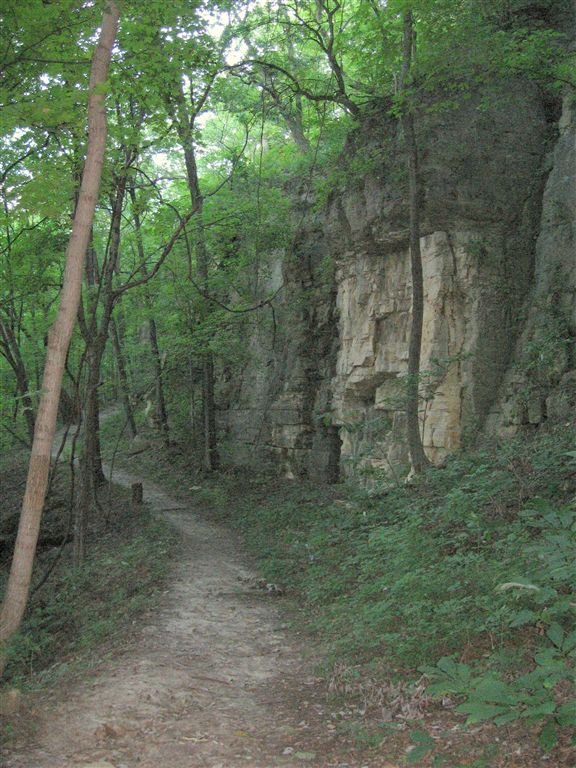
Pick up the Goat Cliff Trail in the southwestern corner of the Visitors Center parking lot. Right away, the trail climbs alongside exposed, rock walls, rising to 50 feet in places. The bluff is peppered with boulders and hunks of rock that have fallen from the cliffs above.
PMT002
Location: 38.9838867, -90.5430069
The observation platform (one of nine on the 12-mile trail system) looks west for a fantastic view of the Illinois River Valley and its surrounding backwater lakes. The trail takes a hairpin turn around the bluff ahead.
PMT003
Location: 38.9805679, -90.5431976
Bear right at this 3-way junction and take the short side trail to McAdams Peak. An shelter erected by the Civilian Conservation Corps provides a panoramic view of woodland, farmland, and the Illinois River bounded by nearby Eagle Lake and Swan Lake farther to the west. Stay right at 3-way junction just past the overlook.
PMT004
ADVERTISEMENT
Location: 38.9796562, -90.5429306
Turn left at this well-marked 4-way junction to follow the Hickory Trail, an old service road, eastward.
PMT005
Location: 38.9791183, -90.5427399
The view at Twin Mounds overlook is of a vast, heavily wooded floodplain created by the confluence of the Illinois, Mississippi, and Missouri rivers. If it’s a clear day, look for the Gateway Arch in St. Louis, 30 miles to the southeast.
PMT006
Location: 38.9789162, -90.5424042
Bear left at this 3-way junction. The trail runs underneath a dense canopy of oak and maple, and traces a ridge eastward. The thickly wooded terrain drops steeply on both sides of the trail.
PMT007
Location: 38.9804268, -90.5310898
Turn right at this 3-way junction, bypassing the Fern Hollow trail and turning south, back toward the Visitors Center.
PMT008
Location: 38.9790726, -90.5304642
The trail crosses the park road at mile 2.5 and turns from Hickory North to Hickory South.
PMT009
Location: 38.9782066, -90.5312347
ADVERTISEMENT
This 3-way junction marks the beginning of the gradual descent along the edge of the bluff.
PMT010
Location: 38.9777985, -90.536377
Continue straight ahead at this 4-way junction, the trail continues bearing west then turns south ahead.
PMT011
Location: 38.9769936, -90.5392456
Follow the trail to the left at this 3-way junction and descend into a pleasant, wooded ravine.
PMT012
Location: 38.9727631, -90.5421753
As the trail nears park headquarters and the Visitors Center, bear left on the road for a detour to the Pere Marquette Lodge. The 30s-era lodge is full of comfy furniture and warm, historical touches, including a 50-foot, 700-ton fireplace.
Limestone Walls
Location: 38.9804573, -90.544487
Walls of limestone line the trail as it climbs the bluff, an ancient faultline that runs 60-miles into both Illinois and Missouri.
McAdams Peak
Location: 38.9803162, -90.5437775
The southwest view from McAdams Peak shows the Illinois River and its backwater lakes.
Twin Mounds View
Location: 38.9790268, -90.5426636
ADVERTISEMENT
Park interpreters say this overlook is the best for fall color viewing, but a clear day in any season will reveal, downtown St. Louis in the distance.