Published September 20, 2013 01:10PM
Sedona, AZ: West Clear Creek
Immerse yourself (literally) in the crystal clear waters of the Coconino National Forest on this multi-day amphibious trek that features classic—and unavoidable—canyon swims.
A classic Arizona canyon thru-hike, this 25-mile trip follows West Clear Creek’s lower reaches to Bull Pen Ranch. Although canyon walls make route finding a breeze, it’s slow-going over slippery rocks and face-slapping overgrowth. (Cold morning swims and wet socks also pose challenges along the way.)
The trail begins with a steep descent to West Clear Creek and a downstream trek through a relatively wide canyon. You’ll cross the creek several times as you navigate toward a narrow section of Coconino sandstone, known locally as the White Box, near mile 10. The White Box is the first of several required swimming sections on the trail. Keep essential gear in dry bags and bring a pool float to ferry packs across the water (an inflatable mattress serves double-duty as a campsite cushion).
ADVERTISEMENT
Fluctuating between wide, flat bottomed creek crossings and narrow, pool filled slots, the canyon descends gradually through distinct sandstone layers and passes several scenic falls before intersecting Trail No. 17. The smooth, well-maintained trail is also popular with day hikers bound for Indian Maid Falls and is another option for the final 5 miles of the hike.
TO TRAILHEAD: Shuttle car: Exit I-17 at Camp Verde and drive east on AZ 260 for roughly 7 miles. Turn left onto FR 618. In 2 miles, turn right onto FR 215 and drive 2 miles (follow signs to Bull Pen Ranch).
Start: Continue east on AZ 260 for 29 miles (just before mile marker 249) and turn left onto FR 144. In 1.8 miles turn left onto FR 149. In 1.1 miles, turn right onto FR 142 at the T-junction. Drive 0.8 mile and turn left onto FR 142E. Continue 2.7 miles to the trailhead.
-Mapped by Todd Martin, author of Arizona Technical Canyoneering

ADVERTISEMENT
Trail Facts
- Distance: 40.2
Waypoints
WCC001
Location: 34.54586, -111.433846
From the parking area at the end of FR 142E, the trail descends a short, steep hill to the creek bed.
WCC002
Location: 34.549496, -111.433843
ADVERTISEMENT
Though campsites are generally well-spaced along this trail, there are no adequate camping areas near the trailhead, or at the end of the first section of red-walled narrows.
WCC003
Location: 34.557042, -111.442909
The trail constantly crisscrosses West Clear Creek. Don’t bother trying to keep your feet dry, even through the relatively open reaches in the canyons upper section.
WCC004
Location: 34.559521, -111.475136
There are several access points to the canyon. This junction for the Calloway Trail leads to the canyon rim at the end of FR 142C.
WCC005
Location: 34.568493, -111.495972
This access point offers a way out of the canyon before the first real swim, and before the spectacular slot canyons downstream. If you can’t swim, or need to cut your trip short, follow this left-hand trail to the canyon rim and the end of FR 142A.
WCC006
Location: 34.571316, -111.522156
As the canyons narrow by mile 10, the trail has descended 800 feet of its steady, 2,500-foot elevation loss. The left-hand trail leads to the rim at Cash Tank.
WCC007
Location: 34.563065, -111.517998
ADVERTISEMENT
Get ready for another swim at Showerbath Spring.
WCC008
Location: 34.545307, -111.623497
The creek cuts through several distinctive geological layers including the reddish sandstone of the Supai. There are several beautiful waterfalls along this section of the trail. After this stretch, the canyon widens significantly.
WCC009
Location: 34.531733, -111.652851
West Clear Creek’s lower reaches are easily accessible via the Bull Pen Ranch Trailhead. The last few miles of this route are a popular dayhike and play destination for folks seeking a secluded wilderness experience.
WCC010
Location: 34.539757, -111.704399
Bull Pen Ranch Trailhead: There is a pit toilet and a primitive campground at the end of this mapped route.
Paradise
Location: 34.549761, -111.43468
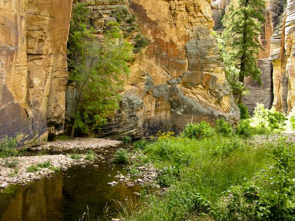
You’ll find buff-colored canyon walls and spectacular views at every turn (and there are a lot of turns) on this classic Arizona thru-hike that follows West Clear Creek. ©Todd Martin
Shimmering Walls
Location: 34.548339, -111.438435
ADVERTISEMENT
Springs seeping from the sandstone walls drip to create lush green areas below the walls. ©Todd Martin