Published June 24, 2010 07:48PM
Secret Hikes: Appalachian Trail
The last lonely stretch of the AT beckons from the mountains of western Maine.
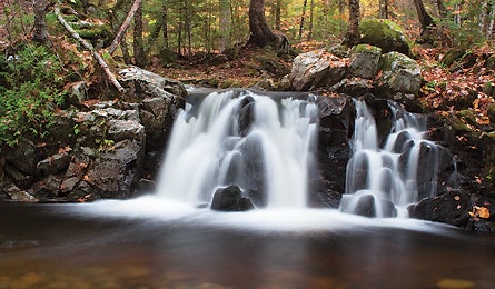
'Mile 10, Cascade Trail - AT (Dean Goss)'
The best secret trail in the East’s national parks isn’t some unknown bridle path in Acadia (there is none), and it’s nowhere near the Smokies (with 9 million annual visitors!). The hidden treasure here is this northern 33-mile section of the Appalachian Trail—yes, the granddaddy of long trails is part of the national park system.
Our map correspondents call this four-day point-to-point, from ME 26 in Grafton Notch to ME 17, “the loneliest stretch of the AT.” Why? Hiker magnets like Baxter State Park and the 100-Mile Wilderness attract the crowds, leaving this stretch blissfully quiet. You’ll traverse the West and East Peaks of Baldpate Mountain and Wyman, Old Blue, Elephant, and Bemis Mountains. This is more than just a series of nondescript peaks: It’s the White Mountains-caliber scenery of western Maine’s rolling mountains and lake-dappled, verdant spruce forests. Don’t try to blitz this route—it’s rocky and lacks switchbacks, and three lean-tos (Frye Notch, Hall Mountain, and Bemis Mountain) are spaced for a four-day trip.
›› Magic Moment Where the AT drops into a saddle between Elephant Mountain and Old Blue Mountain, you pass through an Eastern old-growth forest of red spruce, which germinated about the time the Mayflower reached the New World.
›› Local Knowledge At Dunn Notch, detour .9 mile east off the AT onto the parallel Cascade Trail. It runs another .9 mile along the West Branch Ellis River, passing dozens of falls, including 60-foot-high Dunn Falls. Link back to the AT at East B Hill Road.
›› Do It South end: on ME 26 in Grafton Notch State Park, 18 miles north of Bethel. North end: on ME 17, 26 miles north of Rumford. Map/Guidebook Appalachian Trail Guide to Maine ($28; atctrailstore.org) Contact (304) 535-6331; appalachiantrail.org