Seattle, WA: Norse Peak via Bullion Basin

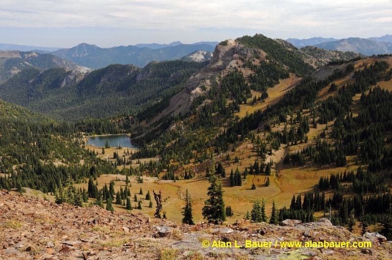
View down into Lake Basin from the PCT below Norse Peak.
During summer months, explore the countless peaks surrounding Crystal Mountain ski area for incredible wildflower displays and up-close views of Mount Rainier. This 8.3-mile dayhike to Norse Peak starts just east of Crystal Mountain’s parking lot and follows an old miner’s road into Bullion Basin, a lush meadow dotted with seasonal wildflowers.
After 1.5 miles, bear right at the Y-junction located in the northwest corner of Bullion Basin, and hike southwest along the edge of the forest. Keep your camera handy: roughly half a mile later, the trail rounds a sharp bend and Mount Rainier pops into view. From here, the route climbs a ridgeline, then merges onto the Pacific Crest Trail (PCT) at mile 2.3. Follow the PCT north past views of Lake Basin and the Norse Peak Wilderness to Scout Pass. Pick up a boot path at the pass for the final 0.4-mile stretch to the 6,856-foot summit of Norse Peak. Savor views at the top before starting the descent back to the trailhead.
-Mapped by Alan Bauer, Alan Bauer Photography

Trail Facts
- Distance: 13.4
Waypoints
BUL001
Location: 46.9371949, -121.4694142
Walk along the road and follow the switchback as it swings to the left. Next, bear right onto the trail, heading into young forest (you’ll re-cross the road in a few minutes).
BUL002
Location: 46.9398394, -121.4673114
Cross a creek and prepare for the grind up a rocky trail (likely an old miner’s road).
BUL003
Location: 46.9394658, -121.4640605
Take a breather and enjoy the views up the slopes toward the Pacific Crest Trail (PCT). Look southwest for views of the Crystal Mountain ski area.
BUL004
Location: 46.9368925, -121.4573304
Stop, turn around, and look at the first glimpses of Mount Rainier to the southwest. Ahead, the old roadbed peters away as the route enters dense forest and the Norse Peak Wilderness.
BUL005
Location: 46.9348048, -121.4541766
The trail emerges from the forest into the lush Bullion Basin (a popular place to camp); seasonal wildflowers speckle the ground. In late summer and early fall, listen for the bugling of elk. Next: Bear right at Y-junction to wander the forested edges of the basin.
BUL006
Location: 46.9309102, -121.4605758
As the trail rounds a sharp bend at the tip of a ridgeline, Mount Rainier pops into view; look for elk far below. Tip: Try to hit this vantage point at sunrise.
BUL007
Location: 46.9287258, -121.4583743
Turn left onto the PCT at Blue Bell Pass. Head north.
BUL008
Location: 46.9325869, -121.4510357
This scenic notch along the ridge showcases grand views to the east of Cement Basin. Look farther east-southeast into the heart of the Norse Peak and William O. Douglas wilderness areas. Pass an unsigned trail that drops down to the east and hike north on the PCT. You may spot elk, deer, marmots, and hawks.
BUL009
Location: 46.9341858, -121.4506495
Keep straight at 3-way junction. Continue north.
BUL010
Location: 46.9516794, -121.4530635
Scout Pass: Peer down at the spectacular Lake Basin to the east (Basin Lake rests in this picture-perfect cirque). From here, find a good boot path on the left side of Scout Pass and begin climbing past whitebark pines and alpine firs toward Norse Peak. Views of Lake Basin, Basin Lake, mountain goats, elk, and Mount Rainier are a constant presence.
BUL011
Location: 46.9569062, -121.4528272
Norse Peak (6,856 ft.): Stand on top of this former lookout site and admire the breathtaking views. Hikers have built benches and small windbreaks from the rocks on Norse’s summit. Mount Rainier rises dramatically to the west. From here, you can see into the dry eastern zones of the Cascades, the Little Naches River drainage, and Ravens Roost. Next: Descend to the PCT. Return to Waypoint 9 and bear right at the junction. Follow trail to Waypoint 5, then turn right to return to the trailhead.
View of Lake Basin
Location: 46.9516684, -121.452806