Seattle, WA: Lake Edna via Chatter Creek

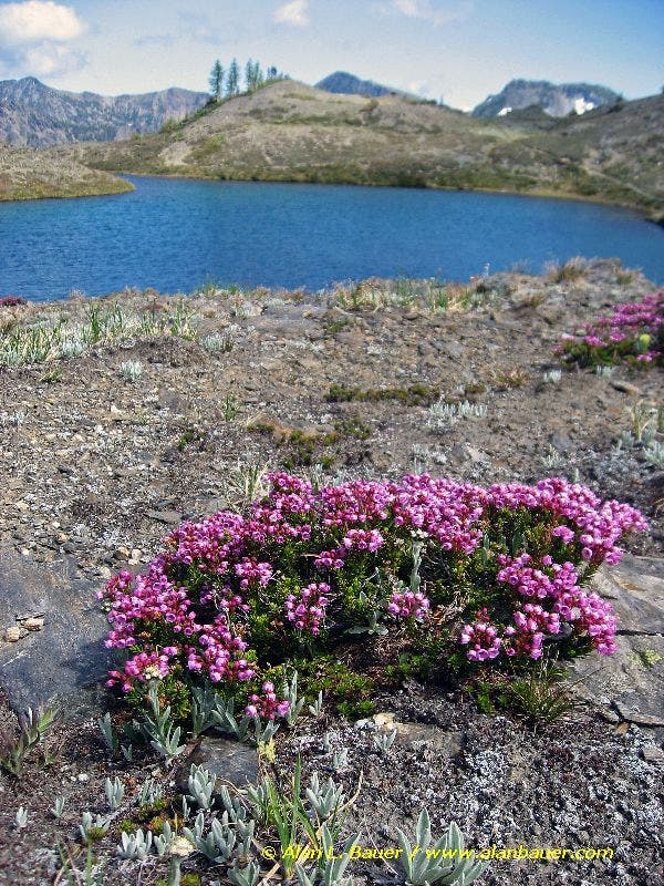
From the trailhead, head north for an easy-going walk through grassland, wildflowers, and a mix of pine and fir. Use this mellow stretch of trail to warm up for the long climb ahead. A mile into the hike, the trail crosses Chatter Creek on a sturdy bridge (a small set of falls can be seen near the bridge) and starts to climb steeply along the creek. After 2.5 miles, the trail begins to open as you cross meadows of bluebells, paintbrush, lupines, and elephant head. From this spot, you can see your upcoming route, which crests a pass on Icicle Ridge after a very steep stretch of trail through brush and rough boulders. From the pass, the trail drops down the north side of the ridge to a basin. (If snow covers this area, you’ll have difficulty following the actual trail.) One mile later, turn left onto Icicle Ridge Trail for the last steep stretch to Lake Edna, a pristine blue lake rimmed by larch trees and heather (blooms in July). Enjoy the scenery, but don’t dally too long at the lake—it’s a long trip back to the trailhead.
-Mapped by Alan Bauer, Alan Bauer Photography

Trail Facts
- Distance: 9.1
Waypoints
CHA001
Location: 47.608056, -120.881833
From the trailhead (marked with a signpost), head north for a fairly flat roam through grassland, wildflowers, and a mix of pine and fir. Use this mellow stretch of trail as a warm-up for the long climb ahead.
CHA002
Location: 47.614384, -120.887768
Cross Chatter Creek on a sturdy bridge shaded by large trees. Look for the small set of falls near the bridge. Stretch your legs and prepare for the climbing ahead.
CHA003
Location: 47.616921, -120.888788
Pass a signpost that marks the Alpine Lakes Wilderness boundary. The stiff climb starts here.
CHA004
Location: 47.620737, -120.887126
Try to catch your breath while taking in views across the Icicle Creek Valley. From this vantage point, you can see the massive Doctor Creek slide area that caused the 2008 spring flooding of Icicle Creek (the flooding also damaged the road to the trailhead).
CHA005
Location: 47.623676, -120.883708
Rock hop across Chatter Creek (the second and final crossing). This crossing should be fairly manageable by mid- to late-summer on a log and 3-4 nicely-spaced rocks. In early summer, be prepared to get very wet crossing the creek. Keep climbing–wildflowers ahead.
CHA006
Location: 47.630582, -120.884832
The trail begins to open as you cross meadows of bluebells, paintbrush, lupines, and elephant head. The first views of Grindstone Mountain appear to the northwest. Look to the north-northwest to see your upcoming route that crests the very distant pass on Icicle Ridge.
CHA007
Location: 47.636659, -120.897498
Hammer up this very steep stretch of trail toward Icicle Ridge on intermittent switchbacks that cut across brush and very rough, rocky boulders.
CHA008
Location: 47.640459, -120.903623
Continue heading north toward the pass through monkey flower and lupines. The trail opens to abundant views south over the Icicle Creek valley toward the Enchantment peaks. Hike along the creek, which crashes down steeply, forming little sets of waterfalls.
CHA009
Location: 47.64325, -120.904773
The trail crests the pass along Icicle Ridge. Grindstone Mountain rises directly to the southwest; look northwest to spot Cape Horn (Lake Edna is nestled at the foot of its slopes). Next, the trail drops down the north side of the ridge, losing 400 feet very quickly. Caution: Snow lingers here well into the summer.
CHA010
Location: 47.645574, -120.906206
Hike north through the basin, passing a sweet camping spot nestled on a knob in the larch trees. Look for cairns to the west of this point to find the official trail that leads right below the cliffs that rise ahead. If snow covers this area, you’ll have difficulty following the actual trail.
CHA011
Location: 47.654245, -120.906714
Turn left @ T-junction with Icicle Ridge Trail #1570. Begin the last steep stretch (0.3 mile) to Lake Edna. Pass through lush, tundra-like meadows dotted with larch and alpine fir.
CHA012
Location: 47.65652, -120.911702
Lake Edna: Edna’s pristine blue waters are rimmed by larch trees and heather (blooms in July). Views of Big Jim Mountain can be seen from the lake outlet. Optional: Scramble up another 400 feet to the summit of Cape Horn. Don’t dally too long at the lake if you’re not planning to spend the night (it’s a long way back to the trailhead). Retrace your steps to the trailhead.
Lake Edna
Location: 47.6562825, -120.9109783
Brilliant heather flowers grow near Lake Edna. ©Alan Bauer