Seattle, WA: Evergreen Mountain

This 20.1-mile trek to Evergreen Mountain was once a short, 3-mile out-and-back before recent floods damaged the road to the trail. Although an 8.7-mile road walk is now required to access the Evergreen Mountain Lookout Trail, hikers who put in the extra effort will experience a more solitary landscape rife with wildlife and spectacular views of the Cascades.
To complete this route in one day, bring a mountain bike and ride the road to the trailhead. Park at the junction of FR 6554 and FR 6550, then tackle a steep climb up FR 6554. After 4.2 miles, the road flattens as it curves into the Elbow Creek drainage and crosses the first substantial washout along the road. (Navigate a second washout less than a mile later.) At mile 8.7, the road passes the trailhead parking area. Lock your bike to a tree, then follow Evergreen Mountain Lookout Trail to the northeast.
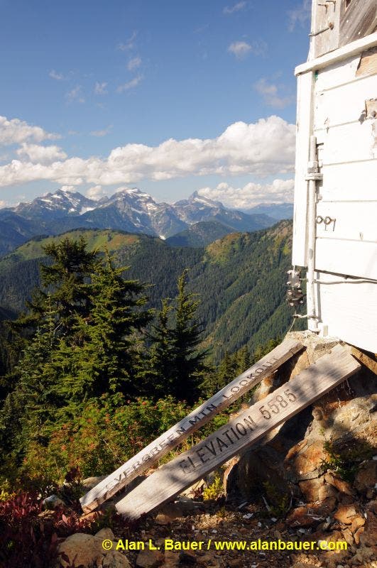
After a steep switchback climb up the ridgeline, the route crests the ridgetop, then ascends slopes dotted with lupine, tiger lilies, and asters. After 10 miles, the route tops out on the 5,587-foot summit of Evergreen Mountain, marked by a picturesque lookout cabin. Stay for awhile and soak up the stunning views of West Cady Ridge, Benchmark Mountain, and the Monte Cristo Range before starting the return trip.
For more information, go to Evergreen Mountain Lookout Trail #1056 and Evergreen Mountain Lookout.
-Mapped by Alan Bauer, Alan Bauer Photography

Trail Facts
- Distance: 32.4
Waypoints
EVG001
Location: 47.8696108, -121.3125043
The route starts at the junction of FR 6554 and FR 6550. Hop on your bike and tackle a steep climb up FR 6554 (closed to cars). After a mile, the road descends to Evergreen Creek.
EVG002
Location: 47.8617333, -121.2805741
Round a sharp bend in the road, then cross a bridge over Evergreen Creek. Keep an eye out for bears in the brush that flanks the creek; you may also spot hummingbirds zipping around the salmonberry.
EVG003
Location: 47.8472607, -121.286264
The road flattens as it curves into a gully (Elbow Creek drainage). At this point, hikers will have to maneuver across the first substantial washout along the road. To the right, huge, 6-foot culverts clogged with rock lie in the creek.
EVG004
Location: 47.8390459, -121.2827887
Maneuver across the second big washout along the road. This is a warm, sunny place to take a break before tackling the remaining 3.6 miles to the original trailhead. Ahead: Pass open views across the Beckler River Valley; raptors circle above in the updrafts. Columbine, tiger lily, and asters line the road.
EVG005
Location: 47.8277209, -121.2822604
Prepare to climb a steep stretch of road (fully exposed to the sun); you may have to push your bike up this section.
EVG006
Location: 47.8269358, -121.2769282
The road reaches the trailhead parking area; alder trees have started growing in the gravel, and bear scat covers the ground. Lock your bike to a tree and enjoy the massive views from the parking area. Next, head to where the road crests the saddle and follow the unsigned Evergreen Mountain Lookout Trail to the northeast.
EVG007
Location: 47.8270654, -121.2742674
The trail pops out on the ridge, revealing stunning views into the Alpine Lakes Wilderness, over the Beckler River Valley, and toward Mount Rainier. This open area of the old clear-cut is thick with wildflowers; don’t be surprised to find bears below you in the huckleberries and ash. More steep climbing ahead.
EVG008
Location: 47.8287869, -121.2691712
The terrain levels off as it departs the brushy slopes of the new forest and enters massive old forest. The trail winds through sparse ground cover and begins a gentle climb up the ridgeline.
EVG009
Location: 47.8329572, -121.2659526
From the saddle along the ridgetop the trail begins a steep climb north. Ahead, the forest transitions to meadows.
EVG010
Location: 47.8337062, -121.2663066
Ascend slopes dotted with lupine, tiger lilies, and asters. Look up the slope to the northeast for views of the summit and the Evergreen Lookout. Be on the lookout for bears that wander around these heather, huckleberry, and wildflower slopes.
EVG011
Location: 47.8365672, -121.2638763
Evergreen Mountain: From this 5,587-foot perch, you’ll find stunning views north to the lush meadows of West Cady Ridge, Benchmark Mountain, and the Monte Cristo Range. A picturesque, 14-by-14-foot lookout cabin sits on the summit. Built in 1935 as a fire lookout, the Evergreen Mountain Lookout was also used during wartime as an aircraft warning station. (Note: Due to the flood damage on FR 6554, the lookout is unavailable for rental until further notice.) Stay for awhile and soak up the views before beginning the return trip.
Evergreen Mountain Lookout
Location: 47.8366662, -121.263442