Published September 20, 2013 04:50AM
Scottsbluff, NE: Fossil Hills
Roam Nebraska's Niobrara River valley, just like the rhino-sized Menoceras did 20 million years ago. This wheelchair-accessible 2.9-miler climbs to one of the world's most important bonebed excavation sites.
Stop at the visitor center for a quick lesson on area geology and a 12-minute video about the park history before setting out on this 2.9-mile lollipop loop. The wide, paved path dips toward the Niobrara River’s wetland floodplain before beginning a steady 150-foot climb to the base of an ancient watering hole—the reason for the abundant 19-million year old fossils found here. The trail levels at the saddle between University and Carnegie hills and winds between them, stopping first at an exposed cross-section of rock showing ancient muddy footprints.
Rounding the south side of Carnegie Hill, signs explain the history of the excavation site which has supplied many Miocene-era museum collections. A shelter at the top of the ridge offers an excellent view of the river valley and the path you’ll re-trace heading downhill toward the trailhead.
Rattlesnakes live near the trail and sometimes sun themselves on its warm surface. Don’t let pets or small children wander ahead and watch your step, even on the trail. Also, be prepared for fast-changing weather and harsh exposure to the sun; the only shade on this hour-long route is at the two trailside shelters.
-Mapped by Kristy Holland


Trail Facts
- Distance: 4.7
Waypoints
FSL001
ADVERTISEMENT
Location: 42.4257215, -103.7335646
This hike begins at the museum and visitor center. Follow the paved path past the tepee and across the flat prairie bench carved by an ancient river.
FSL002
Location: 42.4252028, -103.7326741
Pass the picnic areas on your left and take either branch of the trail at this split. Heading left will take you past interpretive signs about the area’s invasive plant species, but the trails re-join less than 100 yards ahead.
FSL003
Location: 42.4248504, -103.7301716
A wide wooden bridge crosses the wetlands of the Niobrara River. Look for snapping turtles and even beavers in this wetland formed by the slow moving river. Birds, including the western meadowlark (Nebraska’s state bird) are also common here.
FSL004
Location: 42.422128, -103.7260625
ADVERTISEMENT
The first of two trailside shelters offers a bench and the prairie’s only shade. This trail is wide and paved, making it wheelchair accessible, but the steady incline might warrant a rest stop for kids or novice hikers. The trail continues uphill toward the saddle on your right.
FSL005
Location: 42.4169025, -103.7270951
Turn right at the trail junction for the quick spur to the base of University Hill. Interpretive signs point out fossilized footprints in an ancient watering hole.
FSL006
Location: 42.4161382, -103.728447
Extensive slab excavation on the south side of Carnegie Hill supplied fossils for many of the Miocene museum exhibits in museums worldwide. The trail follows the level of the ancient watering hole’s base, so excavations didn’t go any deeper than this 20-million year old rock.
FSL007
Location: 42.4158214, -103.7267733
From this shelter overlooking the trail, take note of the changing colors of the valley below (due to differences in soil moisture). The butte-tops to the north are drier and protected by harder surface rock that will eventually erode into rounded hilltops. Up ahead to your left, the loop portion of this hike closes and you’ll backtrack downhill on the paved path.
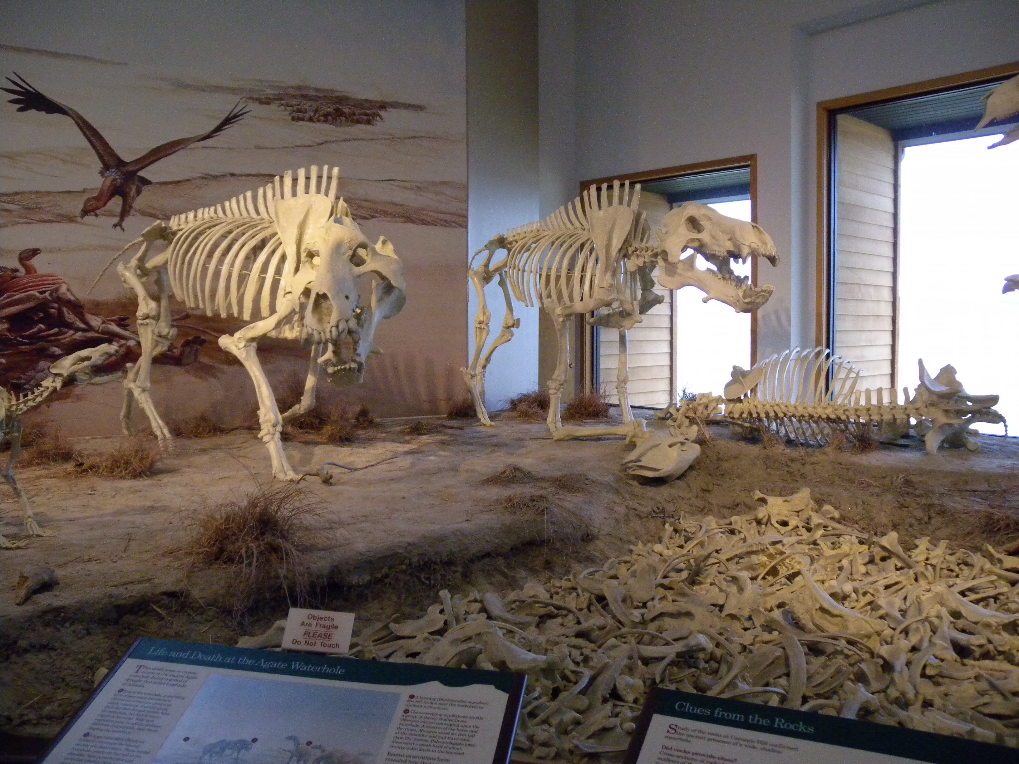
Moropus
ADVERTISEMENT
Location: 42.4256423, -103.7341547
The museum display shows the skeletal remains of Moropus (a distant relative of the horse) and Dinohyus (a pig-like scavenger). Bones of both species have been found in the bone bed.
Rattlesnake
Location: 42.4257374, -103.7342405
Another animal display in the museum: a rattlesnake. Snakes are common in the prairie here and it’s possible you’ll encounter one on the trail.
Picnic Shelters
Location: 42.4252028, -103.7326151
One of several covered picnic shelters near the trailhead parking lot.
Niobrara River
Location: 42.4248464, -103.7301153
The wide wooden platform atop the Niobrara River is a good place to spot wildlife, including spiders, turtles, and muskrats.
Shelter
Location: 42.4221299, -103.7260062
The open prairie doesn’t provide any shade, but two trailside shelters offer respite from the scorching sun.
Yucca
Location: 42.4234149, -103.7270844
Rangers move these trailside signs to highlight blooming plants, including the moth-pollinated yucca shown here.
Interpretive Signs
Location: 42.4170649, -103.7271595
ADVERTISEMENT
Explaining the fossil record, signs on this well-marked trail are entertaining and easy to read.
Trail to Quarry A
Location: 42.4175243, -103.7276208
The trail to Quarry A, the first of many scientific excavation sites in the area, is closed for restoration. Respect the signs and stick to the pavement.
Edge of Carnegie Hill
Location: 42.4164827, -103.7285221
Rounding the west side of Carnegie Hill, watch your step. The trail’s edge gets close to the steep downhill on the right.
Excavation Site
Location: 42.416356, -103.7285274
The rough, open face of Carnegie Hill is the site of the area’s most extensive excavation.