Published September 20, 2013 04:01AM
Sacramento, CA: Independence Trail
Hike, push a stroller, or even roll a wheelchair into a mining relic from 1859. This former aqueduct above the South Yuba River offers easy access to rugged wilderness and amazing mountain views.
In a joint effort, California State Parks and Recreation and the non-profit Sequoya Challenge maintain the Independence Trail, which totals over 4 miles of wheelchair accessible pathways that skirt waterfalls, cliffs, and views of the South Yuba River.
This mapped route follows a half-mile section of wheelchair accessible trail and tacks on another mile (one-way) of hiking trail for a slightly longer, yet still easy-to-access hike. Begin by following the 5-foot-wide channel east from the Independence Trailhead (its main access point along CA 49). Within 0.3 mile, you’ll cross the first of 3 bridges on this section of the trail and pass through a rock arch, tracing the contours of the rugged hillside. The trail remains level as it passes a river overlook and continues east toward the end of the wheelchair accessible segment. From here, continue on a narrower and slightly more rugged trail to a picnic area and small pool on a tributary above the Yuba River.
Note: If you’re looking to add miles to this route, consider adding another out-and-back section on the West Independence Trail from the trailhead, or continuing north on the East Independence Trail which drops down to the river before joining the river to head downstream to the trailhead.
MORE INFO: Independence Trail
-Mapped by Melissa Stolasz


Trail Facts
- Distance: 4.8
Waypoints
IND001
ADVERTISEMENT
Location: 39.292733, -121.095048
There is plenty of parking alongside US 49 near this main trailhead for the Independence Trail. There is also a wheelchair accessible restroom and information kiosk. Note: There are more than 2 miles of trail that extend westward from here as well.
IND002
Location: 39.293557, -121.093814
This well-maintained trail was originally an aqueduct built to transport water to hydraulic gold mines in Smartville. If it’s been raining, check trail conditions to ensure accessibility in the mud.
IND003
Location: 39.294961, -121.093047
Wide bridges, like this one, replaced the old wooden aqueducts.
IND004
Location: 39.295558, -121.092296
Look left for a great view of the Yuba River below the trail.
IND005
Location: 39.296214, -121.089817
Cross another bridge and stop for a photo op in the tunnel-like rock arch.
IND006
Location: 39.296443, -121.089072
This point (half a mile from the trailhead) marks the end of the wheelchair accessible path.
IND007
Location: 39.29928, -121.077311
ADVERTISEMENT
This route ends at a tributary of the South Yuba River where there’s a small pool and a picnic table. Though this route backtracks from here, some people make a loop by heading west to the river and swimming or floating to the trailhead. Caution: The river can be very dangerous, even for strong swimmers, so check water conditions before considering that option.
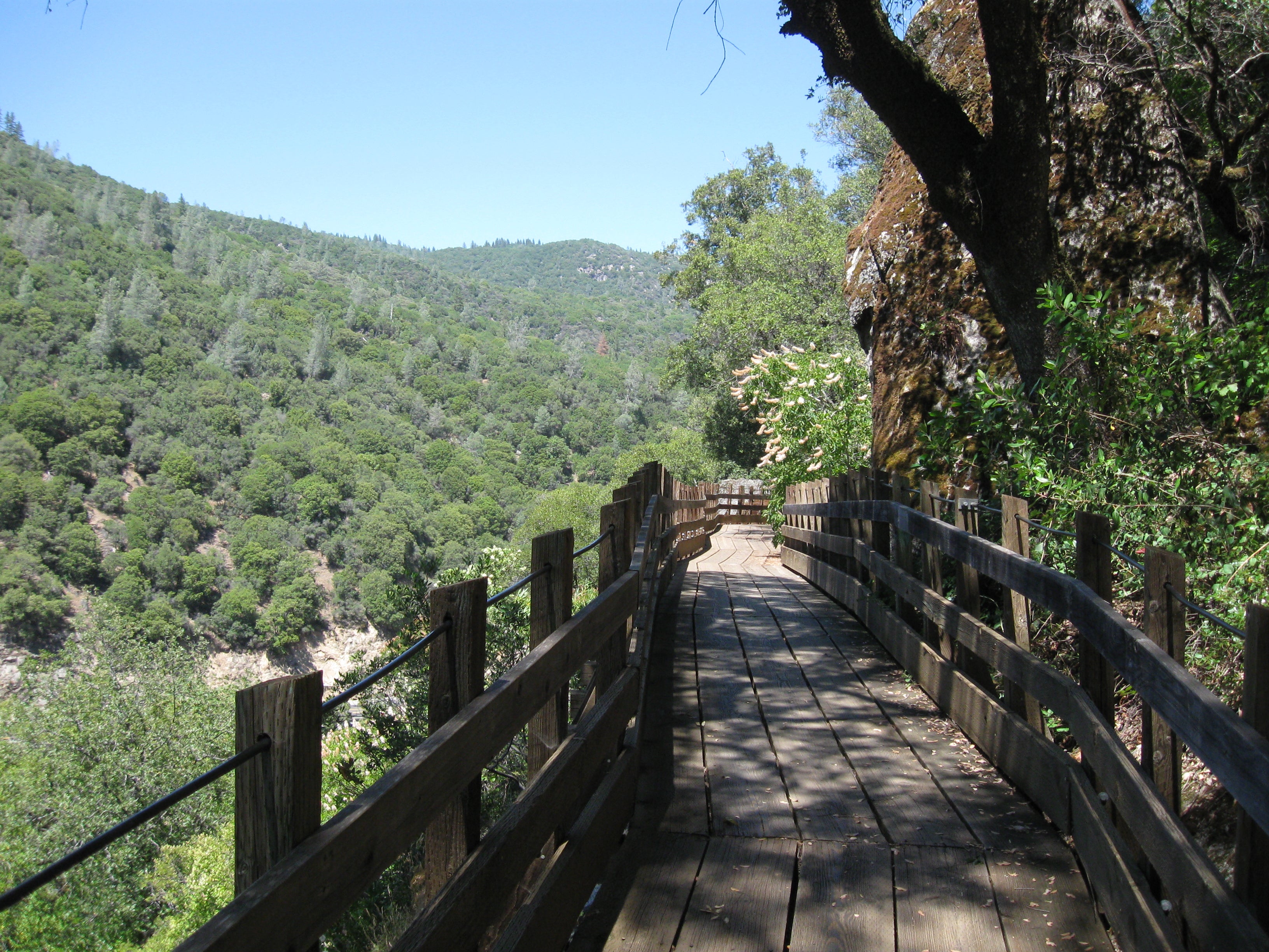
Bridge on Independence Trail
Location: 39.294961, -121.092977
Narrow, rickety aqueducts were replaced by wide wooden bridges hugging cliffs high above the South Yuba River.
Trailhead Kiosk
Location: 39.292737, -121.095015
The map kiosk at the trailhead. This route follows the trail east.
Channel
Location: 39.294367, -121.093213
The wide, deep channel was once an aqueduct, but is now one of the country’s best wheelchair accessible wilderness trails.
Channel Edge
Location: 39.29528, -121.092693
River View
Location: 39.295558, -121.092226
An overlook provides a view of the river and the cars parked alongside CA 49.
Rock Tunnel
Location: 39.29621, -121.089731
One of the amazing things about this trail is the rugged and rocky terrain it traverses.
Long Bridge
Location: 39.296563, -121.087189
Another long bridge on the hillside above the river.
Poison Oak
Location: 39.297368, -121.084056
Keep an eye out for poison oak. It has three leaves with slightly scalloped edges.
Picnic Table
ADVERTISEMENT
Location: 39.29932, -121.076996