Updated December 3, 2024 04:58PM
Rocky Mountain National Park: Pear Lake via Finch Lake Trail
This 12.4-mile out-and-back sweeps under a giant evergreen forest to a blossoming burn zone, then ends at an alpine lake perfect for stargazing.
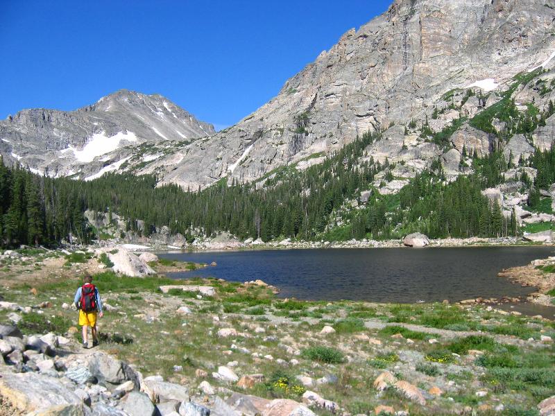
This picturesque alpine lake sits at the foot of 13,176-foot Copeland Mountain and a rugged cirque in Rocky Mountain National Park. Get there on a 12.4-mile out-and-back that starts just east of the large Wild Basin parking area. From the trailhead, follow Finch Lake Trail as it climbs southeast to a narrow ridgeline.
From here, the trail turns sharply west, then levels out, passing through one of the park’s brightest wildflower corridors. At mile 1.4, turn right at the junction, heading west. Half a mile later, stop for views of Mt. Meeker to the northwest. At mile 2.3, continue straight at the 4-way junction, and continue climbing through a burn area, now dotted with flowers.
Near mile four, cross a series of crystalline creeks on log footbridges before skirting Finch Lake .2 mile later. Roughly six miles in, cross Pear Creek and turn right for the final stretch to its namesake lake. Follow the same route back to the trailhead.
ADVERTISEMENT
-Mapped by Caitlin May and Kim Phillips
Plan your trip
MAP
Rocky Mountain National Park ($12, natgeomaps.com)
Order USGS topo quads at store.usgs.gov.
Order a custom map of this route using MyTopo.com
CONDITIONS
Trail Ridge Road is closed from November to April. Check conditions for the east side of the park check Estes Park, CO (80517) Weather
PERMIT
$20 for entry to Rocky Mountain National Park; (970) 586-1242; nps.gov/romo
ROCKY MOUNTAIN NATIONAL PARK INFO
Visitor Information: (970) 586-1206 (daily, 8 a.m. to 4:30 p.m. M.T; recorded information after hours)
Trail Ridge Road Information Recorded Message: (970) 586-1222 (available 24 hours a day, updated when conditions and/or road status change)
Visitor Information for the Hearing Impaired (TTY): (970) 586-1319 (daily, 8 a.m. to 5 p.m. M.T.)
Backcountry Office: (970) 586-1242
GAS
Shell 860 Moraine Ave. Estes Park, CO (970) 586-7867
GEAR
Grab supplies or gear rentals (packs, bags, pads, and fishing gear) at Estes Park Mountain Shop, 2050 Big Thompson Ave., Estes Park, CO; (866) 303-6548.
GROCERIES
The Country Market National Park Village 900 Moraine Ave. Estes Park, Colorado (970) 586-2702
RESTAURANTS
Try a Mountain Mai Tai and the buffalo-and-bacon meatloaf at Peak-to-Peak American Grille, 451 South Saint Vrain Ave., Estes Park, CO; (970) 577-0577


ADVERTISEMENT
Trail Facts
- Distance: 20.0
Waypoints
PLT001
Location: 40.208393, -105.56097
ADVERTISEMENT
Begin hiking uphill on the well-marked Finch Lake Trail.
PLT002
Location: 40.207, -105.547478
Trail turns sharply west, then levels out; pass through one of the park’s brightest wildflower corridors.
PLT003
Location: 40.202149, -105.555718
Turn right at junction, heading west.
PLT004
Location: 40.202149, -105.565288
Break at first vista; enjoy views of Mt. Meeker and skyline of peaks.
PLT005
Location: 40.199544, -105.57042
Straight at 4-way junction, following signs for Pear Lake.
PLT006
Location: 40.19697, -105.571468
Keep climbing; pass through old burn land, now carpeted with flowers.
PLT007
Location: 40.184849, -105.586266
Cross a series of crystal-clear streams on log footbridges.
PLT008
Location: 40.184382, -105.592024
Finch Lake sits in a dishbowl basin of steep evergreen hillsides; hike past several campsites.
PLT009
Location: 40.183808, -105.594192
Continue straight; follow sign for Pear Lake.
PLT010
Location: 40.177201, -105.618889
Turn right after crossing Pear Creek to reach its namesake lake.
PLT011
Location: 40.17666, -105.623438
ADVERTISEMENT
Good spot for stargazing at this high alpine lake, cradled by jagged mountainsides; retrace steps to trailhead.
Pear Lake
Location: 40.176758, -105.623052
Hiking into the rugged basin of Pear Lake
Pear Creek
Location: 40.177217, -105.618696
Views from Finch Lake Trail
Location: 40.177238, -105.62088
Pear Lake
Location: 40.176758, -105.622816
Western edge of Pear Lake
Location: 40.175988, -105.628588