Published September 20, 2013 01:04PM
Rocky Mountain National Park: Boulder Brook to Glacier Gorge
Rushing waterfalls, mountainous views, and a healthy dose of altitude highlight this 6.3-mile loop in Rocky Mountain National Park.
This 6.3-mile shuttle hike south of Moraine Park links the Boulder Brook and Glacier Gorge trails and can be completed in either direction. Start at the Storm Pass Trailhead off of Bear Lake Road for a shorter but steeper climb and a more gradual descent. From the small parking area, hike south through a grassy meadow rimmed by conifers and rocky peaks. After half a mile, the trail enters the forest and begins climbing alongside (and crisscrossing) Boulder Brook.
Tree cover becomes sparse near the top of the climb as the trail nears the junction with North Longs Peak Trail. In autumn, golden aspen groves create a striking contrast with the evergreen forest. After 2.4 miles, Boulder Brook Trail dead ends at North Longs Peak Trail; turn right and start the gentle descent to Glacier Gorge. (Stunning views of the park’s snow-capped peaks appear between the gaps in the trees.)
ADVERTISEMENT
At mile 4.5, cross over Glacier Creek on a wooden bridge—grab your camera, the rushing creek pours through a rocky gorge below the bridge. From here, the trail snakes to the north, passing Alberta Falls, one of the park’s more popular (and accessible) spots waterfalls. At the Glacier Gorge Trailhead, take the free shuttle to the Bierstadt Lake Trailhead, cross the road, and follow the path back to Storm Pass Trailhead.
INFO For information on permits, current trail and camp conditions, and wilderness guidelines, go to nps.gov/romo/planyourvisit/backcountry.htm
PERMIT A wilderness permit is required for all overnight camping in the backcountry. Reservations accepted ($20 administrative fee for permits during peak season). nps.gov/romo/planyourvisit/backcntry_guide.htm
CONTACT Rocky Mountain National Park, (970) 586-1206; nps.gov/romo
-Mapped by Backpacker’s Map Team


ADVERTISEMENT
Trail Facts
- Distance: 10.1
Waypoints
GLA001
Location: 40.320068, -105.620003
From the small parking area at the Storm Pass Trailhead, head south through a grassy meadow rimmed by conifers.
GLA002
Location: 40.319641, -105.619698
Continue straight @ 3-way junction.
GLA003
Location: 40.319149, -105.618103
Cross Glacier Creek on a wooden bridge.
GLA004
Location: 40.31823, -105.616798
Keep right @ 3-way junction.
GLA005
Location: 40.316792, -105.615799
Continue straight @ 4-way, heading south.
GLA006
Location: 40.31374, -105.616898
Pass a cascading waterfall on the left side of the trail. More climbing ahead.
GLA007
Location: 40.311359, -105.616898
Cross the first of three stream crossings in the next 0.5 mile.
ADVERTISEMENT
GLA008
Location: 40.296112, -105.617813
The forested lower reaches of the trail give way to several meadows filled with young trees.
GLA009
Location: 40.293411, -105.617424
Continue straight @ 3-way junction with Boulder Brook Campsite #2. A similar spur trail to Campsite #1 is 200 yards up the trail.
GLA010
Location: 40.288944, -105.617493
Turn right onto North Longs Peak Trail @ T-junction. A group campsite (with privy and bear boxes) is located straight ahead.
GLA011
Location: 40.289118, -105.618407
This split-log bridge makes an easy crossing of the Boulder Brook tributary (the water source for the group campground uphill).
GLA012
Location: 40.301196, -105.631957
Along this gentle downhill section, you’ll catch views of the entire valley and the Glacier Gorge Trailhead below and to the right.
GLA013
Location: 40.299011, -105.638276
A wooden bridge spans this deep, gushing gorge and connects to a slickrock-like section of trail before jogging left.
GLA014
Location: 40.299691, -105.639371
ADVERTISEMENT
Admire the valley views at the rest stop just before the 3-way junction. From here, it’s just 1.7 miles to the Glacier Gorge Trailhead.
GLA015
Location: 40.301376, -105.640411
Stop at this overlook for far-reaching views across the valley.
GLA016
Location: 40.303909, -105.638199
Alberta Falls is a highlight of this route and a turn-around point for many day hikers who started at the Glacier Gorge Trailhead.
GLA017
Location: 40.304634, -105.638626
Heading downstream, the trail skirts the log-jammed river. Stop for an upstream peek at several tumbling cascades as you head downhill.
GLA018
Location: 40.306206, -105.638908
A few user-created trails lead to the edge of a deep ravine. Stick to the main trail: overgrowth and tree-cover make for a less than spectacular scene.
GLA019
Location: 40.306613, -105.641484
Cross the stream on a bridge. There is another crossing a few-hundred feet ahead.
GLA020
Location: 40.307678, -105.643402
Pass a wooden barrier on your right before turning east @ the 3-way junction. Follow signs to the Glacier Gorge Trailhead.
GLA021
Location: 40.307728, -105.642929
Continue straight @ 3-way junction.
ADVERTISEMENT
GLA022
Location: 40.308433, -105.642075
This bridge marks the end of a rock-step descent.
GLA023
Location: 40.310196, -105.64054
The long descent ends near a rock-walled section of trail near the parking area and shuttle bus stop.
GLA024
Location: 40.311283, -105.639282
Glacier Gorge Trailhead: Take the free shuttle to the Bierstadt Lake Trailhead, cross the road, and follow the path back to Storm Pass Trailhead.
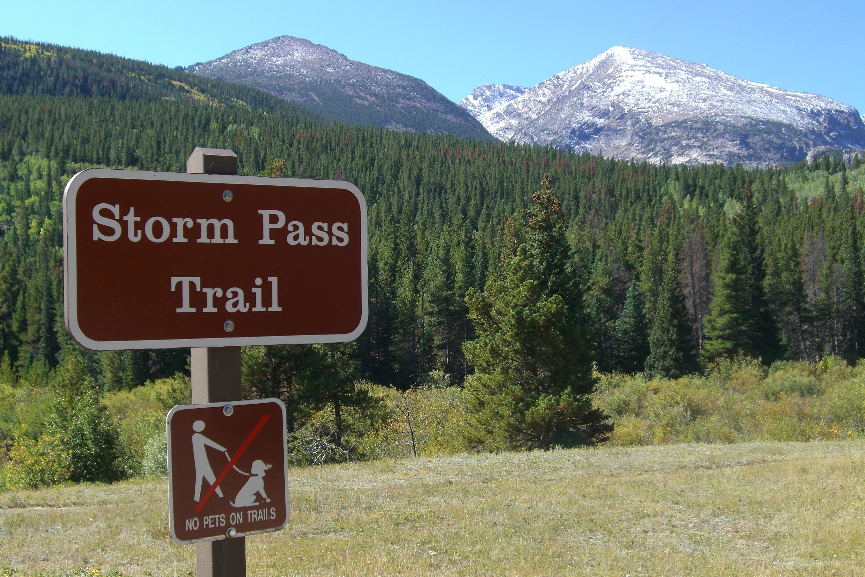
Trailhead Sign
Location: 40.319972, -105.619984
©Kim Phillips
Trailhead Views
Location: 40.319817, -105.619919
©Kim Phillips
Waterfall
Location: 40.313786, -105.616806
©Kim Phillips
Bridge Crossing
Location: 40.311432, -105.61689
©Kim Phillips
Rocky Terrain
Location: 40.290897, -105.617363
©Kim Phillips
Trailside Views
Location: 40.296223, -105.624489
©Kim Phillips
Rocky Peaks
Location: 40.297333, -105.625351
©Kim Phillips
Mountainous Views
Location: 40.298347, -105.625778
©Kim Phillips
Rocky Mountains
Location: 40.299331, -105.626807
©Kim Phillips
Trailside Views
Location: 40.299331, -105.628309
©Kim Phillips
Aspen Grove
Location: 40.299755, -105.634186
©Kim Phillips
North Longs Peak Trail
Location: 40.299656, -105.635651
©Kim Phillips
ADVERTISEMENT
Views of the Park
Location: 40.29903, -105.636986
©Kim Phillips
Rushing Creek
Location: 40.299134, -105.638126
©Kim Phillips
Creek Views
Location: 40.299052, -105.63819
©Kim Phillips
Bridge Crossing
Location: 40.299232, -105.638448
©Kim Phillips
Rocky Mountains
Location: 40.299322, -105.638502
©Kim Phillips
Overlook
Location: 40.301392, -105.640282
©Kim Phillips
Trail Junction
Location: 40.29974, -105.639596
©Kim Phillips
Alberta Falls
Location: 40.303913, -105.638161
©Kim Phillips
Alberta Falls
Location: 40.303848, -105.6381
©Kim Phillips
Chipmunk
Location: 40.305973, -105.638954
©Kim Phillips
Glacier Gorge Trailhead
Location: 40.311081, -105.639252
©Kim Phillips