Updated July 8, 2025 09:42AM
Camp on a Raised Platform in the Roanoake River National Wildlife Refuge
Strap your canoe to the car and prepare to get elevated at this North Carolina haven.
'Fred Wasmer'
“I pull my oar out of the tea-colored water and let my boat bob in the cypress grove. As soon as my canoe comes to a rest, the landscape starts moving. A caramel-colored water snake hangs from a tree branch, craning its neck in my direction. A black armored turtle perched on a log seems to resent my intrusion and disappears in the brown water with a small splash. I feel a world away, and yet I’m just an hour and a half outside Raleigh, paddling Devils Gut, a tight, cypress-filled neck of the Lower Roanoke River. Over the course of our 21-mile route, my party will navigate tree-choked swamps and wide flatwater. We’ll see great egrets standing near the banks and listen to barred owls calling at night. It’s the best safari you can find this close to home.”
Turn-by-turn From Gardner Creek Access in Roberson Marina
- Launch beneath US 64, and paddle 3.7 miles north through twisty, 30-foot-wide Gardner Creek.
- Veer east into Devils Gut, following the brownish river .8 mile downstream.
- Turn north into Lower Deadwater Creek and float .7 mile to the Barred Owl Roost Platform to camp.
- Back in Devils Gut, continue south to the Lower Roanoke River at mile 7.3.
- Paddle another 8 miles past Astoria and Jamesville to Broad Creek.
- Hang a left (west) into Broad Creek, going .6 mile upstream to camp at the Cow Creek Platform.
- Next day, retrace your strokes downstream to the Lower Roanoke River.
- Continue 2.1 miles to the Thoroughfare, a narrow channel that connects the Roanoke and Cashie Rivers.
- Veer north into the flow, and go 2 miles to the Cashie.
- Head 1.4 miles northwest up the wide Cashie River to the takeout in Sans Souci.
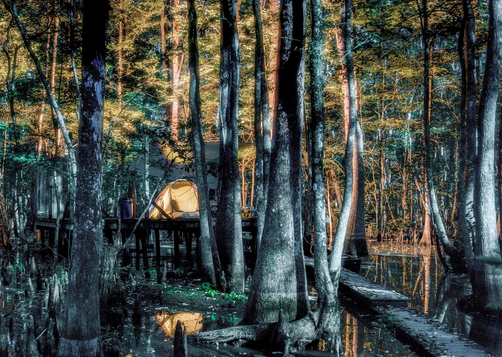
Campsite 1: Barred Owl Roost Platform (mile 5.2)
There’s room for a few tents and chairs on this wooden stage that sits in a grove of 100-foot-tall cypresses (reservation required). Beginning at dusk, listen to the platform’s namesakes hooting and cooing; their song pattern sounds like “Who cooks for you?” (Note: BYO water for the whole trip.)
Campsite 2: Cow Creek Platform (mile 15.9)
Come May, blue flag iris blooms frame this site (reservation required), while red-shouldered hawks sweep overhead. If you position tents near the 30-foot-tall ash trees, you can fit three with water views.
Wildlife of the Roanoake River
The Roanoke River hosts beavers, river otters, and the state’s highest concentration of black bears—as well as venomous cottonmouths, which look unfortunately similar to nonvenomous banded water snakes. Identify the former by its heart-shaped head and narrow neck.
ADVERTISEMENT
Where to Eat on the Roanoake River
On day two, paddle through Jamesville, a tiny (population 464) community on the Lower Roanoke. Near mile 8.9 (around 35.8132, -76.8930), pull ashore at Cypress Grill, an unassuming wooden shack with tasty Southern fare, including fried herring, hush puppies, slaw, and sweet tea.
When Nature Calls
There are no privies and going in the woods isn’t permitted. Instead, bring a lidded, 5-gallon bucket lined with a trash bag and cat litter.
ADVERTISEMENT
DO IT Shuttle car 35.9112, -76.8171; 18 miles east of Williamston on Woodard Rd. (You can hire a shuttle and rent boats from Roanoke Outdoor Adventures in Williamston; prices vary.) Trailhead 35.8114, -76.9329; 38 minutes south of the shuttle car on US 64 Season April to June and September to November Permit Required ($25 per party per night); reserve online. Custom map ($15)