Published June 25, 2013 03:53PM
Rip & Go: Summit Lakes Trail, Lassen Volcanic National Park, CA
Pass sparkling alpine lakes on this easy weekend through volcanic high country.
'Illustration by Peter Sucheski'
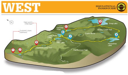
Do it Lake lovers rejoice: You’ll hit eight forested pools on this two-day, 19.1-mile lollipop in alpine terrain where the Sierra Nevada meets the Cascade Range. Even better: no crowds, because big-name neighbors (Shasta, Tahoe, and Yosemite) draw visitors away.
From the Summit Lakes trailhead (1), immediately cross vibrant Dersch Meadows—a frequent grazing spot for mule deer—over a 100-foot-long boardwalk. Dive into white pine and red fir forest, veering left at .3 mile and skirting the North Summit Lake campgrounds. Walk 20 yards along the lake’s northeast edge, forking left at the next junction (2) and beginning a steady 400-foot climb to another junction (3) at mile 1.3 atop a plateau. Here, the left fork leads to the Cluster Lakes—currently inaccessible following 2012’s Reading Fire—so continue across the plateau and descend 250 feet over .6 mile past azure Echo Lake. In 1.4 miles, walk under the steep, forested slopes along Upper Twin Lake’s north shore, and then contour around the rocky southern shores of Lower Twin Lake. Hike east through currant and manzanita clusters and into thinning forest, alongside burnt stumps from a managed 2004 fire. At 5.2 miles, curl around Rainbow Lake (4), where you can see the forested slopes of 7,272-foot Fairfield Peak—one of Lassen’s three cinder cones—mirrored on calm waters.
Continue east and delve into ghostly forest: Bleached tree skeletons and charred trunks litter the floor. Listen for skittering golden-mantled ground squirrels and one of Lassen’s 216 bird species chirping and cawing in this .7-mile section of flash-burned forest. At 6.3 miles, begin a 1.3-mile-long descent (look for new undergrowth sprouting through the charred fir and pine) to the southwest shore of Snag Lake (5)—one of the largest and shallowest (average: 25 feet deep) lakes in the park. See 7,577-foot Ash Butte to the east and the bronze-streaked basalt Fantastic Lava Beds to the north. Venture .1 mile north along the shore to find secluded campsites on the forested peninsula, where you can take a dip and watch the setting sun paint the surrounding peaks in glorious alpenglow.
Next morning, continue 3.1 miles south on the main trail alongside Grassy Creek, hugging the hillside, and zigzag over the water on wooden bridges. At 9.6 miles, stay right and continue following the meandering creek amid wide meadows. Hit the east shore of choppy Horseshoe Lake (6) and spy Lassen Peak poking through the forested basin’s horizon to the west. Next, pass an unnamed pond surrounded by rolling meadowland. At 12.7 miles, trace the base of 7,267-foot Crater Butte, the second of the three cinder cones. (An overgrown, .4-mile-long trail ascends Crater Butte at a 35-degree angle, affording a panoramic view of the park over a small crater lake.) Hike .5 mile and connect with the PCT (7) at 13.6 miles. Return to Lower Twin Lake (8) under a shady forest canopy, and turn left. Retrace your steps 4.4 miles past Upper Twin, Echo, and Summit Lakes to your car.
If Lassen Peak is covered in white this summer, it’s probably not snow. Look for the white and lavender endangered Lassen Smelowskia flower (budding late july) clustered on peaks.
ADVERTISEMENT
Get there From Redding, go 47 miles on CA 44 E to the park entrance. Continue 13 miles on CA 89 to the Summit Lakes trailhead. Gear up Redding Sports Ltd; 950 Hilltop Dr., Redding, CA; (530) 221-7333; reddingsportsltd.comContact (530) 595-4480; nps.gov/lavo Season June through October for snow-free hiking