Published June 25, 2013 05:24PM
Rip & Go: Outer Mountain Loop, Big Bend National park, TX
Trek through wide-open desert and ascend big-view mountains in the still-wild West.
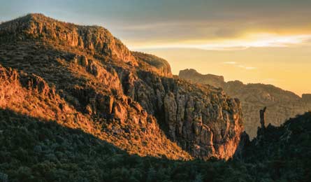
'500-million-year-old rock outcroppings (Photo by Erik Walker)'
Do it Wade through tumbleweeds on a two-night, 29.6-mile loop along the Mexican border.
First, cache water for the last night and day in the bear box near the Homer Wilson trailhead. Back at the Chisos Basin trailhead (1), climb 1,600 feet over 2.7 miles under maple and pine to a 6,995-foot saddle (2) and glimpse the loftiest summit in the Chisos Range: jagged, pink 7,825-foot Emory Peak. Keep straight on the Pinnacles Trail along the right side of lush Boot Canyon—the only U.S. home of Colima warblers and Mexican junipers—and watch for javelinas snacking on prickly pears. At mile 3.8, turn left onto Juniper Canyon Trail (3) where Boot Springs dribbles underfoot. Descend 1,941 feet over 2.9 miles under 100-foot-tall Arizona cypress trees (the largest in the country), and emerge into the desert. At mile 6.7, take the faint boot trail (4) on the right for .1 mile and post up at grassy, shady Juniper Canyon Camp (listen for the nighttime hoots of Big Bend’s 12 native owl species).
Next day, return to the trail and hike 3.4 miles south in Juniper Canyon. At 10.1 miles, exit to the right via the Dodson Trail (5) and walk along the Chisos’ foothills (see Mexico to the south). Skirt left of the 1920s Dodson family ranch ruins (6) (look for a rusted bed frame), and wind through the stony trailbed to trickling Fresno Creek (7)—your only hope of water (check with rangers beforehand to see if it’s running). Scan the creek for Sierra Del Carmen white-tail deer. Drop into the Smoky Creek drainage (8) at 16.7 miles, following cairns among 65 types of cactus. The trail leaves the wash in 3.5 miles (9). From here, walk .7 mile to your cache at Homer Wilson Ranch (10). Keep right, traveling through red-walled Blue Creek Canyon—where you can make a secluded camp (11) among fragrant pinyon pines.
Next day, leave the riverbed after a 2.8-mile, 1,320-foot climb where Bryce Canyon-like pink volcanic tuff hoodoos tower overhead (12). Enter the High Chisos oak and juniper groves, and continue on the Laguna Meadow Trail, curling around familiar Emory Peak (13). Hit vast, golden Laguna Meadow (14) at mile 26.5, and continue north, descending 1,270 feet over the final 3.1 miles to your car (15).
Look for scarlet, chalice-shaped Claret Cup cactus flowers (budding in June) coloring both the Chisos desert and woodlands. Beware the 2- to 3-inch spikes.
ADVERTISEMENT
Get there From Alpine, take TX 118 to Study Butte; go 26 miles east to Big Bend NP headquarters. Gear Up Far Flung Outdoor Center, 23310 Farm to Market 170, Terlingua, TX; (800) 839-7238; bigbendfarflung.comSeason Year-round (the high country can be 20 degrees cooler than the low desert); June to avoid late-summer thunderstorms Contact (432) 477-2251; nps.gov/bibePermit Required; $10 (in addition to a $20 entry fee)