Updated July 8, 2025 02:16PM
Rip & Go: North Fork Mountain, Spruce Knob-Seneca Rocks National Recreation Area, WV
Climb sandstone outcroppings and spot raptors on this wildlife-packed ridgeline.
'Illustration by Peter Sucheski'
Do it Catwalk a mountain ledge with never-ending Appalachian views on this 11.4-mile shuttle hike. You’ll split the North and South Forks of the South Branch Potomac River along a 2,500-foot-high ridge in West Virginia’s Alleghenies, just 150 miles west of Washington D.C.
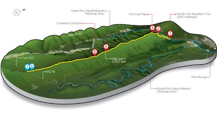
Head out on the North Fork Mountain Trail (501) from the northern terminus (1) and immediately ascend broken purple sandstone in an oak, maple, and chestnut forest. On the mountain’s western edge (2), scramble up a rhododendron-lined, class 3 slope on the .1-mile side trail (3) to 3,120-foot Chimney Top. This natural sandstone pillar offers 360-degree views of the weathered rock formations atop the forested Dolly Sods plateau to the west and the North Fork’s jagged, quartzite cliffs to the south (peregrine falcons and golden eagles often circle the cliffs on thermals).
Return to the main trail and continue on the north-south ridge, hiking through vibrant green ferns. The North Fork South Branch Potomac River snakes through the greenery below the sheer drop-off to the west, while the South Fork and 4,000-foot-high Allegheny Front parallel you (2.2 and 13 miles east, respectively). Hike alongside dwarfed pines that form a veil between the trail and western cliff edge. Ascend to the 3,500-foot high point (4) and enter a corridor of pink mountain laurel (blooming in June) with an understory of blueberry shrubs (ripe in August). At mile 7.4, reach the Redman Run Trail (507) and look downslope for an unnamed campsite with a large, stacked-stone fire pit (5). You’ll be in prime position to catch a killer sunset over the Alleghenies from a 30-foot rock outcropping and feel the rising sun on your tent through a break in the canopy.
Rejoin the Tuscarora sandstone ridgeline as it slims to a 10-foot-wide knife edge for .5 mile (with valley views on either side) before entering a pine forest littered with lime-green, lichen-covered boulders. At mile 11, veer west (6) to scramble atop sloped rock fins to westward views, including 4,770-foot Mt. Porte Crayon (often smothered in clouds), before dropping 100 feet through a hardwood forest into a natural saddle. Continue .1 mile to gravel FS 79 (7) and your shuttle car.
Get there From Harrisonburg, take US 33 west 65 miles to Seneca Rocks, then take WV 28/55 north 14 miles. Turn right on Smoke Hole Canyon Rd. Shuttle car Continue 11.6 miles south on Smoke Hole Canyon Rd. to CR 2/4; go west. CR 2/4 turns into FS 79; follow it 3.5 miles to North Fork Mountain Trail. Park here. Trailhead Retrace your route; drive north 11.2 miles to the North Fork Mountain Trail (501) northern trailhead. Gear Up The Gendarme, junction of US 33 and WV 28, Seneca Rocks; (304) 567-2600; thegendarme.com Season The trail is in the best shape during summer and fall. Contact (304) 257-4488; fs.usda.gov/mnf
Camp-n-climb: trad climb at seneca rocks—the only eastern Peak accessible only by technical climbing—off wv 28. For more info on the quartzite crag, see climbing.com/route/seneca-rocks/.