Published February 11, 2013 02:10PM
Rip & Go: Lost Maples Loop, Lost Maples State Natural Area, TX
Warm up for hiking season with a mellow escape to a maze of limestone plateaus.
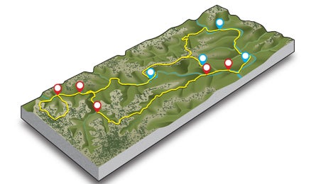
'Lost Maples Loop (Mapping by Melissa Gaskill)'
Do itThis small park just 90 miles from San Antonio offers a quick-access pocket of classic Texas Hill Country, including wooded canyons, craggy bluffs, and gentle streams. Cover it all in an easy weekend on this 10.4-mile route.
From the west parking area (1), follow the dirt-and-gravel East Trail through woods of oak and juniper where endangered black-capped vireo and golden-cheeked warblers nest in spring. At .3 mile, turn left onto the West Trail, using stepping stones to cross clear, shallow Can Creek (2), then follow smaller Dry Can Creek along limestone bluffs where ferns line dripping overhangs. Climb 150 feet to the top of a 2,200-foot-high plateau with 360-degree views of rocky, wooded hills.
Pass the turnoff to Campsite E and descend a long, steep slope 400 feet into narrow Mystic Canyon(3) to enjoy its shade and sculpted rock walls. The park’s isolated stand of Uvalde bigtooth maples survived in these cool, moist, sheltered canyons when the climate warmed after the last ice age; distinguish them from look-alike sycamores by their paired leaves on opposite sides of the stem.
At mile 2.6, turn left on West Loop Trail, and pitch camp under abundant oak and cedar trees around a small meadow at the park’s most remote campsite, G (4) (no open fires; filter water from the stream nearby). Grab a daypack and complete the West Loop (5)before dark, hiking 1.9 miles past a spring often adorned with dragonflies. At dusk, watch for park denizens such as gray fox, white-tailed deer, armadillo, javelina, and even bobcat.
In the morning, head .2 mile back to the West Trail, turn left, and follow Can Creek 1.2 miles to the Ponds (6), a pair of small lagoons nestled against weathered limestone; look for shimmery green kingfishers. A bit farther, pass Campsite C, then turn left onto the East Trail. Hump 350 feet up a steep, rocky ridge for views of the ponds below and the canyons beyond. Half a mile later, drop your pack and turn right onto a .4-mile spur to a scenic overlook (7) on a promontory, with views of West Canyon and Can Creek. Back on the main trail, continue across cactus- and juniper-studded open terrain, then descend loose rock and steps to denser, taller woods at mile nine (8). Here, two creeks join to form the clear, green Sabinal River; follow it through maple stands, crossing several times on stepping stones. At mile 10, traverse the day-use area(9)and walk the short trail back to your car.
Get there From San Antonio, drive 53 miles on TX 16 N. Turn left on Ranch Rd. 337. In 20 miles, turn right on Ranch Rd. 187 and drive five miles to the park entrance on your left. Take the first left past park headquarters to the trailhead parking area.
Gear up Whole Earth Provision Company, 255 E. Basse Rd., San Antonio; (210) 829-8888; wholeearthprovision.com
Season Winter and spring; summer is hot, and crowds descend in October and November for the foliage.
Fees $3/person entry plus $10/night per campsite
Contact (830) 966-3413; bit.ly/LostMaplesSNA
BUY THE PRO MAP