Published November 14, 2012 06:26PM
Rip & Go: Little Blakely Trail, Ouachita National Forest, Arkansas
Hike through old-growth forest to ridgetop views of Arkansas's largest lake.
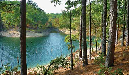
'Ouachita's Submerged Trees (Photo by Granger Meador) | Granger Meador'
Do it
In early November, this mellow overnighter offers fiery autumn colors along an 11.5-mile loop perfect for a leisurely late-season escape. Miss the show? No problem. Once the leaves fall, the lake views get even better. Your route follows a network of five stacked loops that spiderweb across a wooded peninsula jutting into Lake Ouachita (WOSH-i-taw). Start where gravel FR 30200 ends, near a skinny inlet (1).
Cross a footbridge and follow a trickling creek up one of the trip’s few hills to junction K (2) (trail signs label most intersections). Turn right on the North Loop, then make a quick right again at junction J. White blazes mark the way northeast on an old logging road through a mixed hardwood forest of red and white oak, ash, maple, and hickory. Pass a gateway of boulders and descend into a north-facing, pine-dominated landscape with a lush green understory (3). Soon, scattered 150-year-old loblolly pines soar more than 100 feet skyward (4). The lake teases with come-and-go glimpses, but for now the trail remains about 500 yards from the blue-green water. Turn right at mile four (5) and snake around a bay. In .6 mile, pass near a waterfall tucked in a tight cove (6) (a 300-yard bushwhack gets you there). Cross a slender creek feeding the falls and loop west, keeping your eyes peeled for red-tailed hawks or black vultures. When the trail nears the end of the peninsula (7), follow faint game trails toward the water to stake out a sweet shoreside campsite with island views (8).
Pick your own dispersed spot at the edge of the woods with a westerly vantage for a killer sunset. Next day, follow the ridge east, accompanied by views of the shark tail-shaped bay below. In 1.7 miles, turn right at junction G (9) onto the Glades Loop and pass through emerald-green stands of aromatic red cedar. Some skeletal trees still remain here from a fire a decade ago. With barely a ripple of elevation change, it’s easy hiking around the loop’s far turn and back northeast to junction F (10). Veer left here for a .4-mile stroll to junction L (11). Head east along a sometimes-there creek, staying alert for woodpeckers, painted buntings, summer tanagers, and other songbirds in the hollow. Another .5 mile leads to the familiar start of the North Loop (12), and it’s downhill from there to the trailhead (13).
Get there From Hot Springs, take US 270 W a mile to AR 227 N. In 12 miles, turn right on FR 30200. Go 2.5 miles to the trailhead.
Gear up Ouachita Outdoor Outfitters, 112 Blackhawk Ln., Hot Springs, AR; (501) 767-1373; ouachitaoutdoors.com
Season Best in fall for colors (early November), or while trees are bare in spring and fall
Contact (501) 984-5313; fs.usda.gov/ouachita
BUY THE PRO MAP