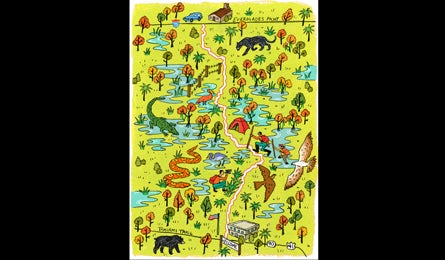
Rip & Go: Florida Trail, Big Cypress National Preserve, FL

'Florida Trail (Illustration by Vikki Chu)'
Do it Plunge into a tropical swamp—home to alligators, bobcats, black bears, and panthers—on a wild stretch of trail two hours west of Miami. With an elevation change measured in inches, this 30.7-mile shuttle route is doable as an overnight—if the path is dry (take an extra night if not). When water is low, search the cypress stands for remaining pools to drink from (or pack in water; ask rangers about current conditions).
From the Oasis Visitor Center (1), shoot north for a mile next to a section of marl prairie. Marl—a gray mud formed from dissolved limestone—is slick when wet, so watch your step. Grasses give way to slash pine as swamp-buggy tracks cross and join with the trail—stick to the orange blazes. Stay right when the Blue Loop Trail splits off at mile three (2). Travel through a mix of prairie and dense forest to Seven-Mile Camp (3), one of several named, high-and-dry sites you’ll pass (but you can camp anywhere out of sight of the trail). In .2 mile, stay right at the second junction with the Blue Loop. Watch for bluebirds, red-bellied woodpeckers, and short-tailed hawks among the pines and cabbage palms. For the next 2.4 miles, cross high ground to Ten-Mile Camp (4), a good place to stay if you’re spending two nights.
In another 2.6 miles, skirt Lost Dog Prairie (5), a huge field of head-high sawgrass. The trail here may be waterlogged, so wear shoes with good drainage and carry poles. Return to the forest for another few miles. Set up at Thirteen-Mile Camp (6) (which is oddly located at mile 17.1), with room for one tent amid dense palms. If the ground is dry, consider camping earlier, at any open patch after about mile 14, for a chance to see a spectacular sunset.
Next day, continue north through a patchwork of slash pine and prairie. Watch for a barbwire fence in 3.2 miles (7). At mile 22.9, pass Oak Hill Camp (8), a shady hardwood hammock (local parlance for an island of trees) at the edge of Mullet Slough (park here on night two of a longer trip). This is the wettest section: The next 4.1 miles can be waist-deep in fall, and typically stay wet into spring. Ivy Camp at mile 27 (9) is another island of dry ground. From here, it’s 3.7 miles through increasingly open prairie to the trailhead along I-75 (10). Look for air-rooted bromeliad plants on dwarf cypress; they sprout firework-like red and yellow bloom spikes year-round.
Get there Shuttle car: From Miami, take I-75 W to the rest area at mile 63. Trailhead: Continue 16 miles on I-75 W; turn onto FL 29 S. In 17 miles, bear left on US 41 E; go 21 miles to the Oasis Visitor Center.
Gear up Bass Pro Shops; 11551 N.W. 12th St., Miami; (305) 341-4200; basspro.com
Contact (239) 695-1201; nps.gov/bicy
Season February to April, for the best balance of dry feet and drinking water