Published May 9, 2013 01:14PM
Rip & Go: Eagle Creek Loop, Columbia River Gorge, OR
Spot waterfalls and wildflowers on a rainforest loop into one of the gorge's wildest canyons.
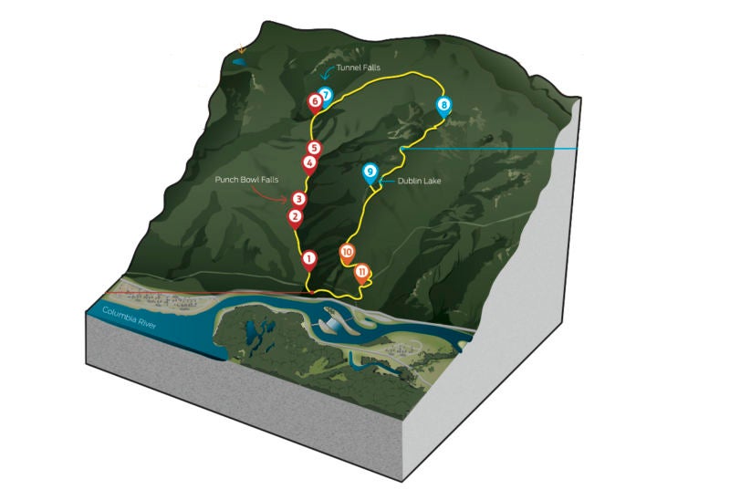
Do itThere’s no shortage of hiking options in the Columbia River Gorge, but with waterfall-lined canyons gushing during the spring snowmelt, this three-day, 22-mile loop is a go-to May hike. Head out from the Eagle Creek trailhead (1)on Trail 440 and wind above the churning waters of Eagle Creek—sometimes 25 feet wide. Beginning in April, monkeyflower, Columbia wind flower, and star-shaped coast manroot decorate the trailsides with blossoms. At mile 1.4 (2), veer right on a signed, 200-foot spur to check out Metlako Falls, a 100-foot horsetail. On the main trail, continue .5 mile to Lower Punch Bowl Falls (3) for a creekside view of the 12-foot-tall curtain of water. Lounge on rock slabs and take a midhike dip in the pool above the falls. In .2 mile, look out for 36-foot-tall, plunging Upper Punch Bowl Falls—named for its resemblance to a giant ladle dipped into a bowl—to your right. Continue upcanyon and catch a glimpse of 60-foot Loowit Falls (4)spilling over the canyon’s west wall 1.2 miles farther. Next, cross a wooden bridge over a narrow, 120-foot-deep slot above Eagle Creek. Bypass often-overcrowded Tenas Camp at 3.7 miles (5) and continue your gradual ascent past more cascades (now to the left of the trail). Post up at Blue Grouse Camp (6), beyond the Trail 434 junction at 5.2 miles. Pick one of four campsites, each big enough for multiple tents, on the flat wooded area near the creek (no fires allowed).
Next morning, continue .6 mile on the trail to thundering, 160-foot Tunnel Falls (7). Here, follow the trail into the misty canyon. Stay close to the cliffs and use cables to navigate over slippery rock as you pass behind the falls through a 20-foot-long basalt tunnel. The trail curls around a rock amphitheater overlooking Twister Falls, where Eagle Creek splashes through two cracks in the canyon wall, corkscrewing and spilling into the basin 200 feet below. In 1.3 miles, continue straight onto Trail 433 and pass over Eagle Creek via a bridgeby fording the 30-foot-wide waters (continue upstream to find a shallow crossing), beginning a 2,000-foot climb over 3.5 miles through old-growth cedar. Cross a saddle north of Thrush Pond at 11.5 miles (8) and hike around the west side of 4,500-foot Tanner Butte, following Trail 401. At 15.4 miles, turn right at the fork and descend .2 mile to Dublin Lake (9) to cast a line and make camp amid lush greenery. Next day, continue north on Trail 401 past the unmaintained Wauna Point Trail (10) at 17.9 miles and exit the wilderness at the Tanner Butte trailhead (11) at 19.7 miles. Descend east 2.5 miles on the service road back to the parking lot.
Massive lava outpourings inundated eastern Oregon 10 to 17 million years ago, forming the basalt cliffs that line Eagle Creek. Look for different rock layers indicating individual lava flows.
ADVERTISEMENT
Get there From Portland, take I-84 east into the Columbia Gorge National Scenic Area. Take exit 41 to the fish hatchery, turning right to the Eagle Creek trailhead. Gear up REI, 4105 NW Johnson St., Portland, OR; (503) 221-1938; rei.com Contact (541) 308-1700; fs.usda.gov/crgnsa Season May through November; falls gush more late-spring and early-summer, but crowds dwindle later into the fall. Fees Grab a free wilderness permit at the trailhead; parking passes cost $5/day. Trip data backpacker.com/hikes/2107550