Published June 5, 2012 07:46PM
Rip & Go: Citico Creek Loop, Cherokee & Nantahala National Forests, TN/NC
Plunge deep into quiet Appalachian hollows and traverse narrow ridgelines with views across row upon row of forested peaks.
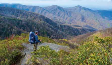
'Photo by Peter Rives'
Wilderness solitude requires some sweat equity on this two-night loop that packs 13,223 feet of elevation change into 21.3 miles. But the effort is well-rewarded with sweeping vistas, narrow ridgelines, hidden forest valleys, refreshing waterfalls—and very little company.

1. Begin on an old Forest Service road (it becomes singletrack at mile 1.2) to climb 900 feet over the next 3.5 miles. The dense forest transitions from pines to oaks and poplars and finally to rhododendron and mountain laurel.
2. (2.7) Water up at a reliable, piped spring before your dry first night’s camp.
3. (3.5) Bed down on the open, grassy summit of Bob Stratton Bald.
4. (5.8) Detour .2 mile to The Hangover, a rock tongue covered with a thin blanket of rhododendron, for uninterrupted views of sparkling lakes and rolling ridges.
5. (8.5) Descend 2,100 feet to Big Fat Gap. Turn left to continue your descent for an additional 1,200 feet over the next 2.5 miles through alternating hemlock and hardwood forest.
6. (9.9) Ford 30-foot-wide, two-foot-deep Slickrock Creek with caution (the footing is treacherous; see page 48 for crossing tips). Watch for coyote, black bear, and whitetail deer that are drawn to the isolated forest basin.
7. Detour .6 mile (round-trip) to four-tiered Wildcat Falls, which ends in a deep pool perfect for a dip. Backtrack to rejoin the loop. Tip: For a one-night trip, camp above the falls.
8. (12.7) Camp at the flat, forested site of a former homestead and apple orchard. Fill water .2 mile before camp. Next day, head southwest on Trail 95.
9. (13.5) A brief section of cliffside trail allows views over stunted mountain laurel to yesterday’s ridge and the creek basins below before you descend to Big Stack Gap.
10. (17.5) Turn right onto the Benton MacKaye Trail.
11. (18.1) Hop the headwaters of Citico Creek’s North Fork before ascending through a shimmering stand of yellow birch.
12. (18.6) Turn left onto Trail 149.
13. (19.7) Right turn onto dirt Strawberry Knob Road to close the loop and return to the trailhead.
Trip Planner
Get there From Knoxville, take I-40 W to I-75 S. In 24 miles, exit onto TN 68 S and turn left to follow it for 24.4 miles. Turn left onto TN 165 E/Cherohala Skyway and go 24 miles to the Beech Gap trailhead at the TN/NC state line.
Gear up Little River Trading Company, 2408 E. Lamar Alexander Pkwy., Maryville, TN; (865) 681-4141; littlerivertradingco.com
Contacts (423) 253-8400; fs.fed.us/r8/cherokee
Trip data backpacker.com/hikes/1672709