Updated July 11, 2025 01:12PM
Rip & Go: Bartram Trail - Nantahala National Forest, NC
Climb past a glimmering highland lake to a lofty southern bald.
'(Photo by: Peter Rives)'
Do it
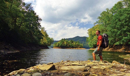
Follow in the footsteps of legendary 18th-century explorer William Bartram—linking tranquil hollows and skirting a wild river—on this challenging 21.1-mile, two-night shuttle hike. The yellow-blazed Bartram Trail honors the man who spent four years documenting the Southeast’s wilderness. From the Beechertown trailhead (1), climb .2 mile of switchbacks, then join a forest road to start a 2.9-mile, 1,500-foot climb. Passing views of cloud-trapping gorges, the trail narrows (2) through tunnels of rhododendron and mountain laurel (blooming late spring) before you traverse the eastern flank of 4,052-foot Rattlesnake Knob (3). Soon, Pierce Creek’s burble signals the first night’s camp (4) at mile 4.3, where dense second-growth provides tethers for a load-lightening tarp (“Key Skill,” next page). Next morning, hike 2.5 miles through rolling forest before turning south (5) to wind along the Nantahala River on 4.7 flat miles with access to swimming and fishing. A six-inch-deep ford (6) across concrete at the base of a 250-foot rockfill dam signals the start of a 400-foot climb past a spillway-fueled waterfall. From here, a 1.5-mile wooded traverse yields the trip’s first glimpses of 1,065-acre Nantahala Lake. At mile 14 (7), the trail follows Wayah Road .6 mile along the lake’s shoreline to the inlet of Winespring Creek (8)—the last reliable water before camp. Turn left to re-enter the rhododendrons and start the 2,300-foot climb over 5.2 miles of McDonald Ridge. At the flat, viewless summit of 5,440-foot Winespring Bald (9), the Bartram Trail merges with the AT. A spring just beyond makes this a welcome, primitive high-country camp. Next day, skirt the northern slopes of Wayah Bald for 1.3 miles, with intermittent views toward the dark ridges of Great Smoky Mountains National Park. From 5,342-foot Wayah’s stone summit tower (10), take in views of undulating, hazy blue ridges and peaks. To finish, backtrack 150 yards to the parking area.
Trip Planner
Shuttle car: From Asheville, take I-40 W to US 74 W. In 61 miles, turn left on Wayah Rd., go 19 miles, turn left on Wayah Bald Rd., and park at the summit.
Trailhead: Backtrack 22.8 miles to the Beechertown trailhead.

Shuttle Jude Julius; (828) 736-0086; $85
Gear up Nantahala Outdoor Center, 13077 Highway 74 W, Bryson City; (800) 232-7238; noc.com
Contact (828) 524-6441; fs.usda.gov/nfsnc
Trip databackpacker.com/hikes/1519292
KEY SKILL: Rig a tarp shelter
Mild weather and few bugs (May to September), plus big elevation changes and plentiful trees, make this a great trip to go ultralight: Leave the tent at home and use a DIY tarp shelter.
» From a home improvement store get a piece of house wrap (such as Tyvek); this waterproof membrane weighs only 1.9 oz. per square foot. Try a 9-by-7-foot piece for a two-person shelter. Also bring 50 feet of parachute-cord and six tent stakes.
» Tyvek doesn’t have grommets. To attach guylines, create a tie-in point by wrapping the fabric (three inches from the edge) over a marble-size pebble. The sheathed rock creates a “handle” that will hold a slip knot
» For general weather protection, pitch a basic A-frame. Tie a piece of cord between two trees at least 10 feet apart like a clothesline (higher for ventilation, lower for added protection). Center the tarp over the cord and stake out all four corners.
» For ventilation in warm weather, pitch a lean-to. Secure one side of the tarp to a line stretched between two trees. Anchor the other side to the ground at the corners using guylines. Be sure to orient the open side of the shelter away from the wind.
SEE THIS: Ramps
These easy-to-collect perennials combine the flavor of an onion with the scent of garlic, and provide a welcome flourish to backcountry dishes. March through mid-May, look for their shiny, smooth, six- to 10-inch-long leaves in sets of two or three, which taper to a purplish stalk and a narrow white bulb that resembles a green onion. Sometimes you’ll see a whole hillside, sometimes just a smattering of individuals, but most often they grow in patches two to four feet across. All parts of a ramp are edible; eat them raw or baked, boiled, steamed, or sautéed into any meal. Bonus: They don’t have a deadly doppelganger (Lily of the Valley resembles the ramp, but its cold-cream smell is a sure giveaway).
LOCALS KNOW
The Cherokee word “Nantahala” means “land of the noonday sun”—describing the deep, narrow gorge formed by the river. Rent a boat, bring your own, or join one of the area’s 12 commercial rafting companies as you charge eight miles through the gorge’s class II and III whitewater. Allow two hours for the trip, which takes you through nine named rapids before the final plunge at class III Nantahala Falls. If you prefer to stay dry, stand on the pedestrian bridge (which doubles as the AT crossing over the river) and watch kayakers and canoeists navigate the slalom course. Better, time your visit to see one of the paddling competitions hosted on the river, including the ICF Canoe Freestyle World Cup (Sept. 7-9) and the ACA Open Canoe Slalom Nationals (Oct. 5-7). For information, rentals, and guide services, contact the Nantahala Outdoor Center (“Gear up,” previous page).