Published March 23, 2009 07:17PM
Ridge Runner
Undeterred by injuries that would cripple most men, a Colorado hiker nears the halfway point in a pioneering attempt to thru-hike the true crest of the Continental Divide. In this extended online interview, Dunmire talks about his gear essentials, near misses, and the challenges that lay ahead as he continues to trace North America's spine.
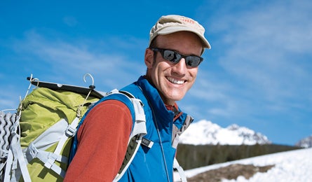
'Dunmire on the Lizard Head Trail, Colorado. Photo by Scott DW Smith.'
Glenn Dunmire was born to the mountains. Raised a backpacker by park naturalist parents, the 48-year-old climbed Katahdin’s Knife Edge at age 6 and summitted Yellowstone’s Mt. Sheridan (a 22-mile, 3,300-vertical-foot round trip) at 7. As a teen, he turned to mountaineering, jumpstarting two decades of cutting-edge alpine ascents. But the peaks took their toll, wrecking Dunmire’s left knee and hand. Lesser men would have hung it up, but the lanky, 6’5” Coloradoan found a new goal: an unprecedented 3,100-mile hike-and-scramble along the crest of the Continental Divide. He wouldn’t follow the well-known Continental Divide Trail, but instead traverse the very spine of the Rockies, where the waters literally part.
We caught up with Dunmire halfway through his journey, which he’s tackling in chunks. What we discovered was a man too humble to admit that his trek—one that was sitting there right under our noses, just waiting for a Messner-like visionary to discover it—could rank as one of the greatest of all time.
Fairly audacious project, Glenn. What inspired it?
My dad worked for the National Park Service, so I grew up in places like Yellowstone, Rocky Mountain, and Isle Royale. He put up the first route on El Cap [the Tree Route], and was on the first attempt on Makalu [the world’s fifth highest peak at 27,765 feet]. I just thought that lifestyle was normal. After college, my brother Pete and I bicycled around Colorado and climbed all of the 14ers in 54 days. There wasn’t much route info in those days, and it was often more efficient for us to just look at the peak from roadside and go straight up, so I learned you don’t always have to stick to a formal route. Later, climbing in Patagonia and Alaska with guys like Jim Bridwell and Carlos Buhler, people with a higher talent and intensity level, it makes you up your game and dream big.
ADVERTISEMENT
When did you actually begin the Divide?
The early ’90s. I thought that with a few food drops I could do hundreds of miles in short order, but this proved unrealistic. Almost all of the terrain is off-trail, the boulder hopping is slow, and you can be striding along for miles until you come to a cliff band—and the next hundred feet takes two hours. You get forced off the ridgelines for water, or to avoid lightning, and the season is pretty short. So the project stayed on the back burner.
But then, three years ago, you got serious about it. What happened?
In 1983, I tore a bunch of ligaments that hold the carpal bones together in my left hand. In 2006, I reinjured it while speed-hiking steep hills with a rock-filled pack, which is how I train for my knee problem. [Dunmire shredded the ACL and most of the cartilage in his left knee in 1978.] That ended my climbing career, but the Divide has been great catharsis.
ADVERTISEMENT
How is the leg holding up?
It’s tough. Compensating for my knee is wearing out my hip, and I can’t squat or bend it more than 90 degrees, so my scrambling has to be pretty well thought-out. I’m also in extreme pain—but there are people with far worse injuries than me who get up every day and go after it. I try to turn my injuries into an excuse to get out. I tell myself, hiking is the one thing that will keep my legs strong.
Many thru-hikers travel uberlight. What’s your style?
I keep my base weight to 20 pounds or less, but I carry a real tent and a Therm-a-Rest so I get a solid sleep every night. I also want hot food, so I carry a stove. When there’s good fishing, I’ll carry a fly rod, because if I can get two meals out of it, I’ve paid for the weight. But wild mushrooms are a more important secondary food source for me. With my ecology background, I’m comfortable identifying and eating them.
ADVERTISEMENT
How do you handle navigation on such a long, complex course?
On a treeless ridgeline, it’s no big deal, but when I’m in the trees or a whiteout, I’ll use map, compass, and GPS together. I haven’t gotten lost, aside from a temporary setback in a snowstorm in the San Juans. I was absolutely sure the GPS was wrong, but of course it wasn’t. The maps have been good, too—I’ve only found one error. In southern Yellowstone, I was climbing over piles of fallen lodgepole from the ’88 fires, trying to follow the Divide despite not touching ground for a quarter-mile at a time. In one minor spot, the map showed the Divide going the wrong way.
What’s been the toughest part?
In the southern San Juans, I kept encountering this band of rock that’s so rotten it’s hard to even stand on it. You can’t be roped up because the rockfall would just cut your rope, and protection points are impossible. It’s as close to unclimbable as anything I’ve ever seen. If I pull off the Divide, I won’t claim to have ‘done it,’ because there are 50-yard sections I’ve had to skirt.
ADVERTISEMENT
What kind of climbing gear are you hauling on the technical sections?
Mostly just an ice axe, which I used a lot in the San Juans last spring for self-arrest and to chip steps in icy slopes. I carried a light rope on some sections, but I’ve never used it. I’ll have to go back with gear for a few spots I wasn’t comfortable soloing, like the Cleaver in Rocky Mountain National Park.
What’s been your favorite area?
Strangely, since it’s low-lying, the Great Divide Basin, south of the Wind Rivers. There are gigantic herds of elk, deer, and wild horses, and lots of sage grouse and mountain plover—along with a huge oil and gas boom. It was pretty surreal with these massive oil trucks rolling by all day. The north end of the Basin hasn’t been developed yet and it’s fabulous, but there are survey stakes everywhere.
ADVERTISEMENT
I also ran into water trouble. Wild horses found some of my cached jugs and stomped them open. I ended up going two days on a single liter, then drinking this nasty milkshake-like stuff from a muddy cattle pond. It was grim. But yeah, that was my favorite area.
What’s up on the Divide that keeps you going back?
Because the crest itself isn’t on trails, and isn’t a destination or a famous peak, it’s not a place people flock to. So the solitude is a draw. And freeform wilderness journeys are where I came from. Going out for a stroll on the Divide under a 50-pound pack just seems like a good, normal thing to do.
What big obstacles lay ahead?
New Mexico has a lot of cruising terrain, but I’ve heard scary stories about armed rancher run-ins, and getting permission [to cross private property] is tough. I haven’t done the Wind Rivers, and I’m looking forward to those the most. The rock is so solid, and every time there’s a thunderstorm, well, that’s just an opportunity to do some fishing. As I go north, the season will get much shorter, and then in Glacier there’s more of that rotten rock.
ADVERTISEMENT
How long will it take you to finish?
Probably several more years. I have much of Colorado and Wyoming done, and some of New Mexico, and that’s taken 100 days. There’s still Glacier and the Wind Rivers. If it weren’t for the realities of life, I’d be done by now. But I have a job, and I’m married, and I’d like to stay that way.