Published November 22, 2011 01:44PM
Readers' Choice 2012: Skyline-To-The-Sea Trail, Castle Rock Sp, Ca
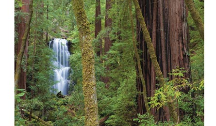
Hike through a towering redwood forest on this easy-access overnighter.
'Berry Creek Falls in Big Basin Redwoods State Park (Hank Christensen)'
When I first started daydreaming about where I’d want to go as BACKPACKER field scout, my mind immediately went to the Sierra and other big-trip destinations. But what I really wanted to do, I soon realized, was share a local trail that showcases my home in northern California. And I knew just the route. I grew up at the foot of the Santa Cruz Mountains in Saratoga, and I live minutes away from Castle Rock State Park and the trailhead for this 29.5-mile point-to-point. Yet I’ve never hiked it—funny how easy it is to ignore what’s right out your door.
The Skyline-to-the-Sea Trail connects Castle Rock and Big Basin Redwoods State Park, home to an 18,000-acre redwood forest. It’s mostly downhill, leading through the wildlife-packed Santa Cruz Mountains, all the way to Waddell Beach, a wide, sandy cove popular with wind and kite surfers. It works best spread over three days.
The first third of the route is a little close to the road for my taste—I could hear traffic—but soon enough you’ll get views of the rolling San Lorenzo Valley before dipping into a mix of grasses, dense hardwoods, then Jurassic Park-like ferns on the floor of redwood forests at mile 20. Pack a bear canister—the campsite raccoons are clever.
ADVERTISEMENT
Add a 2.7-mile detour on day three to explore the prettiest waterfalls: Berry Creek, Silver, and Golden. You could hit just the highlights by starting at Big Basin headquarters and trekking eight miles to Waddell Beach. But when I go again, I’ll keep the same itinerary. Backpacking and camping this good should be savored.
Map Big Basin and Castle Rock Trail Maps ($5 each, 831-335-3174)
Contact Reserve sites two month prior ($15, 831-338-8861)