Published November 22, 2011 01:16PM
Readers' Choice 2012: Shoal Creek Loop, Gros Ventre Wilderness, WY
Backpack to a local ranger's favorite mountain getaway.
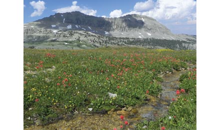
'Indian paintbrush bloom along Shoal Creek Trail (Paul Chisholm)'
Haven’t heard of the Gros Ventre? Neither have most people outside of Teton County. It draws a fraction of the hikers that the nearby Wind River and Teton Ranges do, and get this: The alpine lakes are every bit as stunning as those in the Winds; the wildlife is just as active and diverse as in Yellowstone; the ruggedly vertical high country is reminiscent of the Tetons; and the wildflower displays are the best I’ve seen in three summers of working as a USFS backcountry ranger in western Wyoming. The Reader Leader contest provided the opportunity to piece together the best weekend-size route within it, an 18.9-mile loop connecting the verdant Swift and Shoal Creek drainages.
Start at the Swift Creek trailhead, and hike through meadows to two intersections—take a right at the first and a left at the second to access the Shoal Lake Trail. From there, switchback 2.2 miles on the southwest flank of Peak 11,095. Cross Jack Pine Creek at mile 3.2, then walk through meadows blooming with lupine, larkspur, and sunflowers (in August), before ascending 500 feet to Deer Ridge with a balcony view of 11,404-foot Palmer Peak. Descend and reach an unsigned trail junction at mile 6.3 (go left). As Shoal Creek comes into view, an unmarked use trail to the left brings you to a nice campsite on its banks. Hear a muffled roar? That’s Shoal Falls. Walk up-creek to the base of the cascades, tucked into limestone cliffs, to reach the hidden 60-foot falls.
Next day, ford Shoal Creek (spicy in early summer) and reach a signed junction in .1 mile; head left to reach Shoal Lake in four miles, navigating a fading trail between miles eight and 10 (best bet: follow the path of least resistance upslope). Monster Snake River cutthroat trout thrive here (they crowd the lake’s outlet), and Indian paintbrush and bluebells color the bank with streaks of crimson and violet. If you’re not pressed for time, spend a few nights here to fish (pack hoppers) and sidehike to Brewster Lake at 10,000 feet.
ADVERTISEMENT
To continue the route, climb out of the drainage (sheep, mule deer, and elk are abundant here in summer) and follow cairns across the tundra until you hit Trail 081. Take a left. From here, good signage leads you to the Swift Creek drainage (with Tetons views to the northwest), and a 5.5-mile descent to your car. Posthike bonus: Granite Hot Springs is just 1.5 miles north of the trailhead. You can soak off the miles in a clear pool built by a Civilian Conservation Corps crew in the 1930s.
MapGros Ventre Wilderness Map ($12, see contact)
Contact (307) 739-5500; fs.fed.us/btnf