Published November 14, 2008 01:49PM
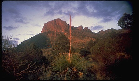
Quick Fix: Big Bend National Park
Scout for gold–and desert views–amid this Texas park's spray of late-fall foliage.
'Big Bend National Park (Courtesy of National Park System)'
3 Hours
Trek to desert treasure.
Conquistador legends tout hidden gold on Lost Mine Peak. But the real riches on the 2.4-mile Lost Mine Trail are wide-open vistas of the sun-burned Chisos Mountains–gained after a 900-foot climb to the peak’s ridge. From mile marker five on Basin Road, you’ll climb gently through piñon and drooping juniper (found only in the Chisos) for a mile to a saddle with airy outlooks into Mexico. The trail then switchbacks steeply, and Casa Grande Peak’s rhyolite towers rise into view to the southwest. Follow the ridge southeast to Lost Mine’s 6,850-foot promontory and its 360-degree panorama. Set off in the early evening to see bats heading out for dinner–20 species call Big Bend home.
5 Hours
Climb to the top of the Chisos.
Early November brings a surprising flush of fall color to patches of maples (yes, maples) on Big Bend’s brown desert peaks, especially on the nine-mile out-and-back hike to 7,825-foot Emory Peak, the highest point in the park. Pick up the Pinnacles Trail past Chisos Mountain Lodge’s stone cabins. Climb for a mile through thick piñon and red oak. Enjoy the grassy flats of two meadows before switchbacking out of the basin. In late fall, the maple stand at the top of the pass glows bright gold and flame red. At mile 3.5, take a clearly marked right off the main trail and hoof it 800 feet up along another mile to an exposed and bouldery 20-foot scramble to the cliff-bound summit.
9 Hours
Hike to hundred-mile views.
In summer, the classic South Rim loop is typically done as a two-day backpack. But you can do this 11-miler in a day in fall’s crisp air. Start early on the Pinnacles Trail (same trailhead as Emory Peak) to beat crowds and reach the rim in time for lunch. After winding through the shady birder’s Eden of Boot Canyon, turn right on the tree-lined Colima Trail. Descend tight switchbacks and turn left at mile 5.5 for the out-and-back to the top of the 2,500-foot-high cliffs of the remote South Rim. After soaking in the sun (and views into Mexico) on the rim’s towering escarpments, backtrack to Colima and turn left onto Laguna Meadow Trail. Pass Arizona cypress and thick, yellow meadow grasses on the three-mile descent.