Published August 26, 2015 10:28PM
Queets River Trail, Olympic National Park, WA
Get wet in late summer when the Queets River is easily crossed to see a rainforest most hikers never knew existed in Olympic National Park, Washington.
'If you can make it across the Queets River without getting to cold the Hoh rainforest will warm you sprits, we just hope your feet will thaw. Photo…'
Big river crossing work like OFF! for many backpackers: Even the stalwart sometimes balk on trips that require high water wading. But if you can perfect your crossing skills and get past a few minutes of numb legs, you can often access miles of private paradise where tenderfeet fear to tread (provided water levels are below dangerous).
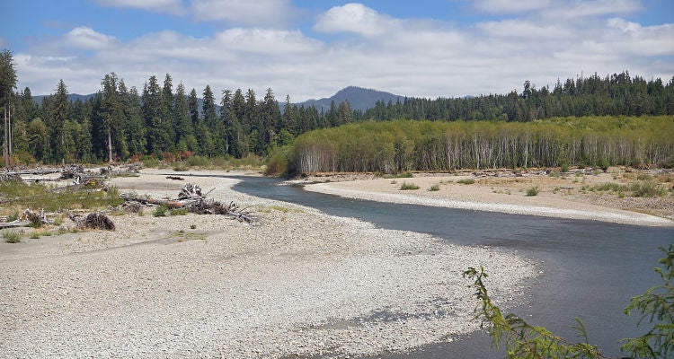
Like a moat around a castle, the 50-foot-wide, often roiling Queets River guards one of Olympic’s most spectacular old-growth rainforests. And because the nearby Hoh Rainforest offers similarly looming trees without the river crossing, it draws the neck-craners, saving the primordial Queets Valley for those willing to brave the trailhead ford. And what a ford it can be: Most of the time, rain and snowmelt feed an impassible torrent. But by late summer, levels usually dip to knee or waist height. If the flow is 800 cfs or below and there’s no rain in the forecast, on the far bank you’ll find 16 mellow miles (one way) of silent strolling under ancient Douglas fir, Sitka spruce, and hemlock of Jurassic proportions. “It’s as remote as you can get”, says ranger Micheal Strunk. “And you see more and bigger trees than in the Hoh.” Bonus: bushes bursting with salmon- and huckleberries (ripe June to August) and plentiful Roosevelt elk and black bears. Note: At press time, a 950-acre fire was burning in this area. Call rangers for updates.
Season Late July to September Trailhead 47.624500, -124.014300, end of Upper Queets Valley Rd. Permit Required; closest pickup at Quinault Wilderness Information Center ($5/person per night) Key gear Sturdy sandals or old sneakers, shorts, and trekking poles for the ford; extra food in case rising water strands you Info http://nps.gov/olym